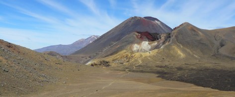
Mount Tongariro is one of several volcanos in the middle of New Zealand’s North Island. It’s the northernmost of the three volcanic cones just to the south of Lake Taupo, New Zealand’s largest lake.
Mount Tongariro is also the location of one of the most popular hikes in New Zealand: the Tongariro Alpine Crossing. This is a 19.4 kilometre hike that climbs over the Tongariro massif, past the summit of both Tongariro and Ngauruhoe.
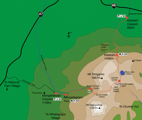
Map is © Copyright Tongariro Alpine Crossing Please visit that site for more information.
A group of us decided to do the Tongariro Alpine Crossing towards the end of the season. We made arrangements and drove down from Auckland on Friday night with the intentions of climbing early Saturday morning. The four-hour drive turned into five and a half as we left during Auckland’s rush hour. We arrived late in the evening and bedded down for the night with alarms set.
A Bad Start
When we awoke on Saturday Morning it was raining and didn’t look pleasant. We went for breakfast and waited to find out if the we could still do the walk. The answer came back a resounding no. The rain and strong winds meant the mountain was closed. All we could do was hang out for the day and hope for better weather on Sunday.
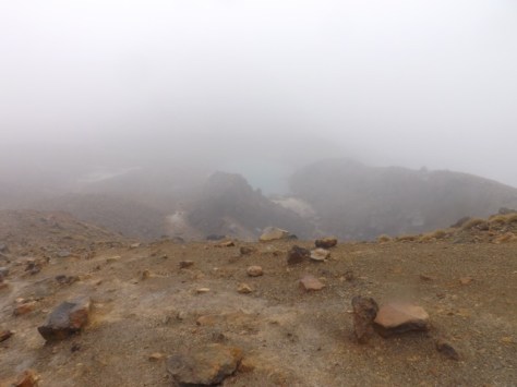
What Tongariro should look like, apparently…
Ominous News
We were up and had breakfast early on Sunday but the weather still didn’t look great. The mountain was still not visible from our lodgings and when our driver arrived he had bad news. He believed the mountain was again closed and wouldn’t take us, leaving us a little downhearted. We asked the owner of the lodge and he was unconvinced. He rang another driver who confirmed the mountain was in fact open and would take us up.
We were driven to the trailhead in the rain with trepidation, but with the number of other vehicles heading up, it seemed others would also be braving it.
Trailhead – Mangetapopo Carpark – 1100m
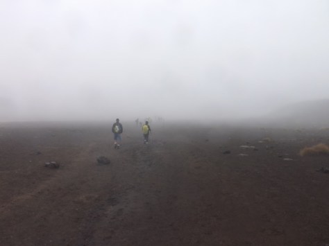
We began at the Mangetapopo carpark in a slight drizzle. There were no views of the massif or much else due to the low cloud. The trail was a mix of mud, stones, wooden platforms and people. There were hundreds of others doing the track with us. If this many were doing it on a bleak day, who could guess how busy it would be on a clear one.

The walk was easy and for the first seven or so kilometres we barely noticed the 250m climb towards Soda Springs. I walked in a quick dry sports singlet, my hiking zip-off shorts and boots. The drizzle was constant but not heavy and I was fairly warm. Others wore long pants and full Gore-tex jackets.
Soda Springs – 1350m
At Soda Springs there is a warning sign: STOP! Are you really prepared? It suggested it was going to get difficult and to turn back if you weren’t prepared. As I waited for my group, I watched several people get to the sign, stare at it for a while and then turn back. With the drizzle picking up I put on a rain poncho over my singlet and began the climb.
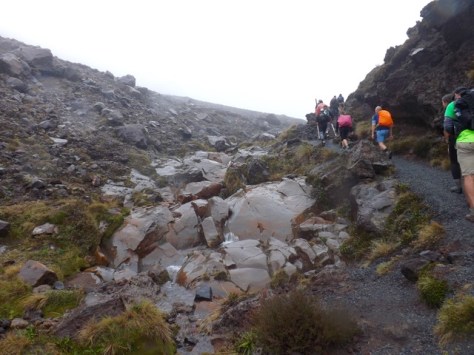
It became more rugged, with a rough dirt trail and steps weaving up the side of the mountain towards South Crater. The drizzle continued and the climb became more a little more difficult, but not by much. After a while of steady climbing we began seeing people returning along with trail with warnings of how bad it was higher up.
With the constant drizzle and the warnings I was tempted to turn back. Why do a climb when you can’t see anything the entire time? You climb for the views and the experience, but the only experience would be a wet cloudy one. I put on a jumper under my rain poncho and we continued on.
South Crater – 1650m
We climbed onto the area described as South Crater and out of the wind. With visibility around 20m we walked on the flat for a while, happy for the rest from climbing.
Red Crater – 1886m
After the mud flats of South Crater we began up the ridge and discovered the wind that had been putting everyone off. It was blowing an absolute gale and you could see the drizzle sweeping over the ridge into the cloudy nothingness. I was not surprised people had turned back but since we’d come this far it seemed silly to head back. We pushed on, dodging between rocky outcrops so as not to be blown off.
We reached the top but couldn’t see anything so just kept walking, beginning the plunge down the other side, some members of our group going arse-over-tit on the slippery silt.
Emerald Lakes – 1730m
The small Emerald Lakes would have been amazing to view from higher up but they only appeared out of the gloom when we were 10m above them. It was still good to see something other than dirt, rock and rain. By now we were completely soaked, we continued on down.

Not far below the Emerald Lakes we came to the Blue Lake covered in the same clouds.
Ketetahi – 1456m
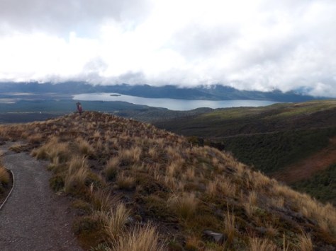
After several switchbacks we finally emerged from the clouds to see the Ketetahi Hut. The drizzle let up but the wind did not. We stopped briefly for a snack before pressing on.
For the next part of the trek we were in open ground along a winding trail. Since a great many people had turned back, we only saw two other groups on the way down. Then having spent much of the day hidden in clouds we finally got some views. Lake Rotoaira appeared and we even got the occasional glimpse of Lake Taupo beyond.
Ketetahi Car Park 800m
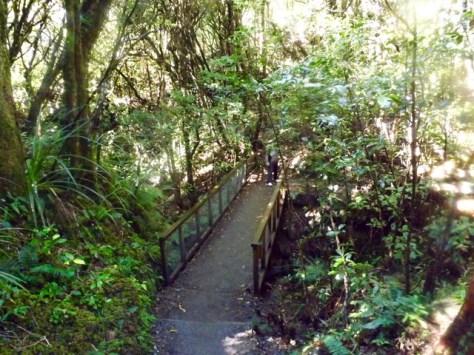
With 4km to the car park the trail dove into rainforest and grew warmer. We crossed a river on a wooden walkway and eventually arrived at the trail’s end after what seemed a lot longer than 45 minutes the sign had suggested.
Overall, due to the weather, out Tongariro Alpine Crossing was disappointing mainly of the lack of views. In the rain and cold, the hike didn’t feel overly difficult. It took us only 5.5 hours of the suggested 8 hours and of the 2.5 litres of water I took with me, I came out with more than 2.
Perhaps it would have been more difficult in direct sunlight, but I’ll have to come back another time to see. Maybe the next time I’m in New Zealand.
The Trail Wanderer
