It’s been some time since I’ve put on a pack and headed out on the trail. I’m now living in London in the UK and decided to get out and see what England had to offer.
After some deliberation, my brother and I settled on a four-day hike around the toe of England in Cornwall, called Land’s End.
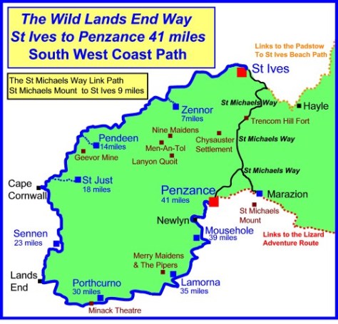
This is my first full coastal hike on what I’m told is the best scenic hike in England. At 66km or approximately 43.5 miles, I split it over 4 days, plus a day to get to and from Penzance, our starting point.
Transport
Land’s End is around 300 miles from London. To get two of us down there by plane or train is very expensive, and we didn’t fancy 9 hours on a bus. This time it turned out far cheaper to hire a car.
Accommodation
There are camping grounds around Land’s End, but we decided to go ‘glamping’. So we booked backpackers and B&Bs to ensure we got a hot shower and soft bed after each day of walking. If you do this, it is best to book a fair time ahead to ensure you get a room, especially in summer when it’s most popular. Also note, most accommodations have late checkout and 5 pm check-ins, forcing hikers to walk during the hottest part of the day.
The day before our walk, we drove down from London, a five-hour trip. We stayed the night before the hike in Penzance and would be staying at the same place at the end of the hike. This was so we could leave the car securely parked for the duration of the walk.
Day 1 – Penzance to Zennor – 11.5km (7 miles)
This first stage of the hike was the hardest but thankfully the shortest. While it is listed as ‘severe’ and ‘strenuous’, I would consider it closer to ‘difficult’, especially in mid-summer under the constant sun.
We left the car outside out accommodation and bought train tickets to St.Ives, taking only 10 minutes and delivering us to the trailhead in style.
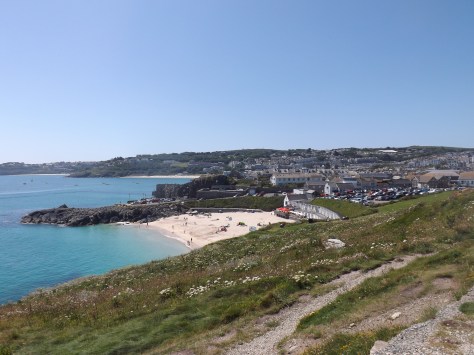
On arrival in St. Ives we found the small town to be set between picturesque gold sand beaches, something not normally associated with the UK. In the blue skies and hot sun of mid-summer, tourists and beach goers swarmed the small town.
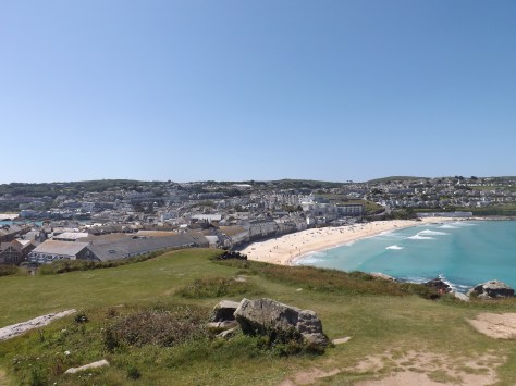
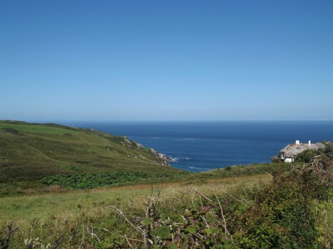
We started the walk with a tour of ‘The Island’ on St. Ives Head giving the above views out across the town and beaches. On ‘The Island’, St. Nicholas Chapel, also gave a picturesque view.

We walked around The Island and then along Porthmeor beach on what was to be the easiest walk of the day. Then, a short climb around the cliffs as he headed towards Clodgy Point.
The initially wide sandy trail weaved through long grasses and short bushes that did nothing to protect us from the constant sun. While there was a very light cool breeze, it did little to alleviate the heat.

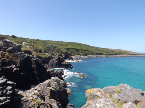
The trail crossed the top of the cliffs, ascending and descending through rocky gullies that lead down to precarious crags. As we headed towards Pen Enys Point, we left the sandy beaches long behind us.

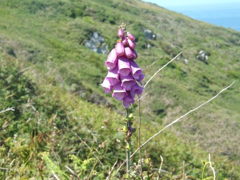
This section of the coast is perhaps the most desolate part of the region except for the occasional Foxglove flower dotted here and there. After two hours, we’d left the touristic day walkers behind leaving only the occasional other hikers.
We pushed on in the heat, following the South West Coast trail around cliffs that just didn’t seem to end. As we made our way past Mussel Point, we found a lone park bench sitting in a short bend on the trail. After hours of hard climbing in the sun, we sat down for a well deserved 30-minute lunch.
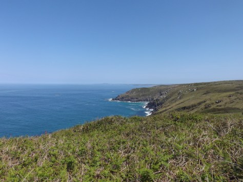
For the rest of the afternoon, we slogged on, climbing across various rocky outcrops until Zennor Head came into view. From here the climbs became longer and steeper until we came over a ridge to see a farm building on the edge of the village of Zennor.
This announced the end of the first day. We headed along a road towards the small village where we could finally down packs and enjoy some shade. We found our way to the Tinner’s Arms, the only pub in the village, and relaxed on the grass under umbrellas enjoying cold drinks until our accommodation, Zennor Chapel B&B opened.
Day 2 – Zennor to St. Just – 18.5km (11.5 miles)
Stage 2 had some difficult parts but was overall fairly moderate.
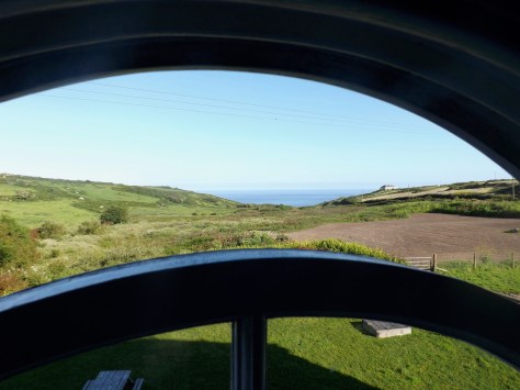
From the window of our room, we could look out to the coast and even watch a family of rabbits play on the lawn. After a refreshing night’s sleep in comfortable beds, we went down for breakfast and picked up our prearranged packed lunch.
We walked out of Zennor in the late morning. The weather was similar to the day before, cloudless blue skies with only the slightest breeze. Without even that slight breeze, the day would have been a lot harder.
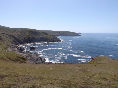
We set out along Carnelloe Cliff with the memories of the previous day still heavy in our minds. But unlike the end of the first day’s with its constant ascents and descents began fairly flat and skirted around the tops of the cliffs. Today we started to see more nettles on the trail and as we both wore shorts we were forced to get used to that constant stinging sensation. We could have worn long pants to avoid this, but in the heat, no thanks!
Out first distant target was a jutting set of rocks known as Gurnard’s Head. As we walked towards it, the climbs began in the heat of the day. After an hour we walked past the rocky peninsula and climbed the Treen Cliff on the far side. We found a set of rocks on the far side with a luxurious cool breeze and stopped for a break.

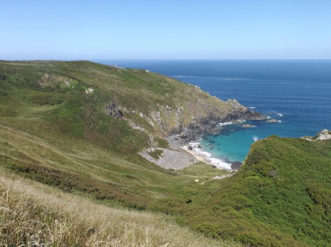
A distance marker pointed us to Pendeen Watch, a lighthouse atop Pendeen New Cliff. We set that as our lunch break point and marched on. The trail, in general, became smoother with less climbing as we followed the clifftops, but the nagging sting of nettles continued. Early in the afternoon, we crossed the Tregaminion Cliff to see the golden sands of Portheras Cove below us. On the other side, we could see Pendeen New Cliff, although no lighthouse yet.
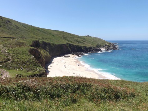
But as we neared the beach, Pendeen Watch did became apparent. We descended into the cove and walked briefly on the sand before climbing the other side. Near the top, a switchback trail descended the hill to a road which climbed again to the lighthouse. We stopped for a well-deserved rest and to eat the rather abundant lunch we’d been provided.

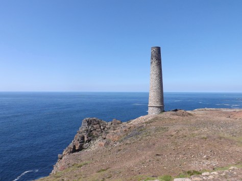
From the lighthouse we could see chimneys further along the trail, marking the entrance of the Levant Mining area. The afternoon sun beat down on us for perhaps the hottest day of our walk. As we entered the mining area, there were far less grassy trails and more gravel. This didn’t help with the heat.
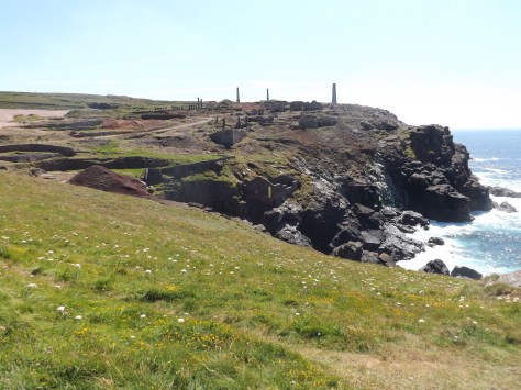
We struggled on as the water in my pack began to grow warm. We were able to find a small shop as part of a museum in the ruins of Britain’s largest tin mine. We purchased a bottle of cold water each and drained them in seconds.
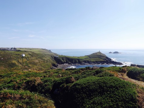
Feeling a little more refreshed, we pushed on along the cliffs to Kenidjack Castle ruins where we got a view of Cape Cornwall and the edge of St Just, our stopping place for the end of day 2.
With our target in sight, our strength’s began to wane, and we staggered into central St. Just, a thriving town which after a couple of days in the ‘wilderness’, had far too much traffic. On arrival, we discovered our accommodation was a mile further on from the town. We rested for ten minutes before pushing on to the YHA Land’s End and a welcome shower.
Next, the final two days of our hike, St. Just to Penzance.
The Trail Wanderer

2 thoughts on “Lands End, England – St. Ives to St. Just, Part 1”