Burleigh Head National Park

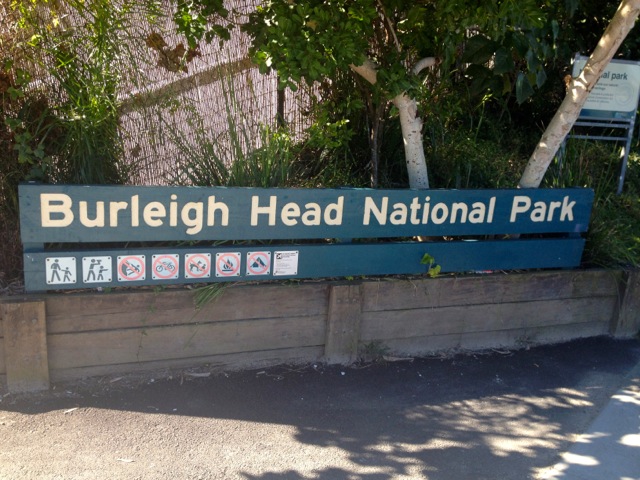
It’s my first weekend back after my Kingdom of Tonga trip and the weather is beautiful, so I decided to get out and do a mild walk. Today I chose Burleigh Head National Park.

Burleigh Head National Park map

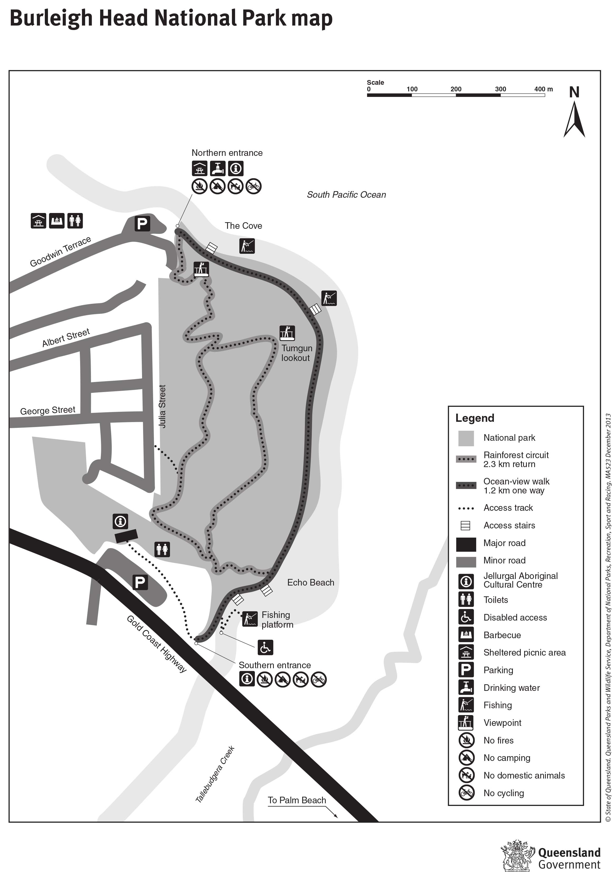
Map is owned by and used with courtesy of Queensland Government.  Please visit that site for more detailed information on hiking in this region.

The Burleigh Heads are a section of beach at the southern end of Queensland’s Gold Coast.  The national park is nestled alongside the creek.

IMG_0646

From the Gold Coast Highway, I walked along the trail at the side of the Tallebudgera Creek with people fishing on my side and sun baking on the other.

IMG_0648


The ‘trail’ is more of a sealed path and is suitable for wheelchair access, which makes it a class 2 track.

wpid-img_0651-2012-07-29-14-28.jpg

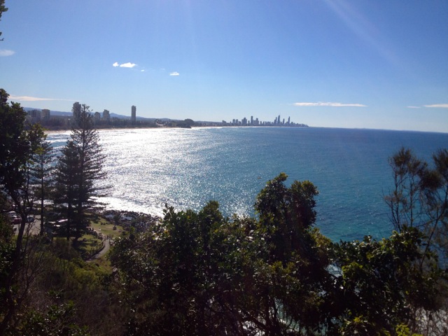
The path either continues around the base of the national park or cuts into it. I cut in and began climbing a fairly steep hill. While much of the national park is rainforest, I liked the great rocky outcrops and boulders alongside the path. After a fair climb up the steepish path, I arrived at Tumgun Lookout and peered out along the coast to the south.

IMG_0652

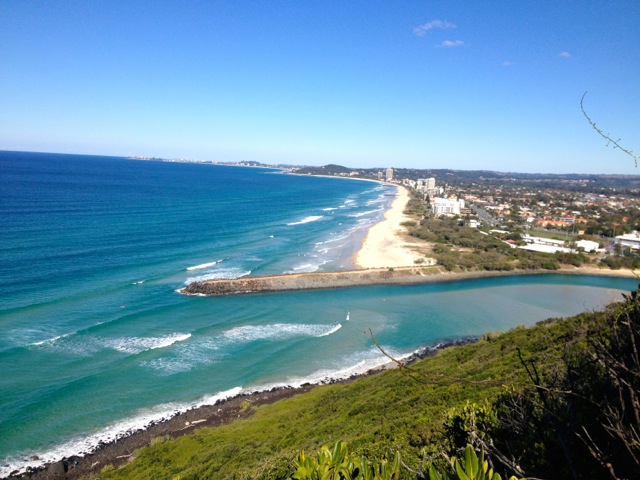
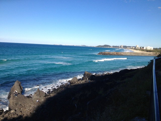
The climb down from the lookout heads down to the beach and contains several sets of short stairs until it emerges at the end of Burleigh Heads Beach and a view along the Gold Coast.

IMG_0657

I headed back up along the path to a junction and headed around the back of the national park, which is not as picturesque as the other way.

IMG_0658

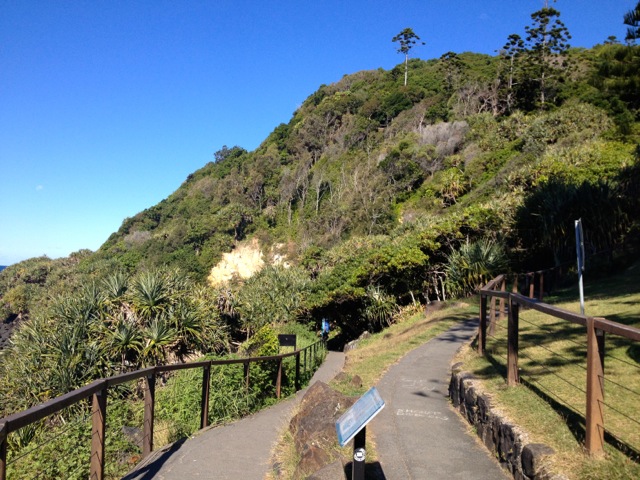
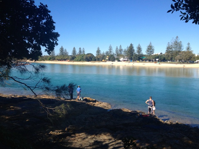
Arriving back at the creek, I followed the lower walk around the base of the national park for another, lower, view of the beach before heading back to the car and home.

IMG_0661

I was only looking for a short walk today and even though the drive to and from this national park combined was longer than the time I spent there, it was still worth the effort and the sweat.

Next week, a real track.

The Trail Wanderer.

Vava’u – Swimming with the Whales

Today is my last day in Tonga and I must admit that I’ve rather enjoyed this little backwater Pacific Kingdom. While Vava’u has been the most commercialised of the islands groups, it’s not really that commercial at all. Tomorrow I face a flight to Tongatapu, a long wait at the international airport until my midnight flight to Auckland. I arrive at 2am and sleep in the airport until my 7am flight to Brisbane and home, well what home I have left there.

wpid-img_0636-2012-07-26-13-57.jpg

Every year as part of their breeding migration, Humpback Whales arrive in Tongan waters. This has led to a commercialised ‘swim’ with the whales all throughout the kingdom. No trip to these islands should be done without going on of the swims. I’m not sure I agree with the idea – some of nature’s creatures should be left to just get on and live, not be harassed by we humans. So, I’ve held out from going for most of my stay. But on my second to last day – yesterday – I caved and organised a trip. As I said, you can’t come to the islands without swimming with the whales.

The first objective of the captain is to find where the whales are, then get up ahead of them and send the swimmers into the water. The whales will often hang out and ‘play’ but if they move away, we get back on the boat and try again. We only try twice before ‘getting the hint’ and finding another set of whales. Because there are many operators, they often work in conjunction with each other to locate the animals and to share time with them.

wpid-img_0641-2012-07-26-13-57.jpg

We headed out to the west side of the islands and quickly located a pair of juveniles playing. We hung out around them for a while, watching them and getting the boat into position before getting into the water. In our snorkelling gear we were able to watch these animals go past. It’s magnificent to see such huge animals in their native environment. They weren’t that playful, however, and moved off. So back on the boat, we followed them and had another go. They moved away quickly again, so we left them alone.

wpid-img_0642-2012-07-26-13-57.jpg

We received a call from the other side of the islands. A crew working in conjunction had spotted a mother and her newborn. Like a tag team crew, we arrived at the specified location as other boat and it’s cargo of swimmers and they headed of – they’d been swimming with the whale for an hour – so it was our turn. We were in the water as the great juggernaut of the mother flowed past us with it’s baby – only a few days old and twice my size. The beauty of the mother just hanging there in the water was immense and we swum for a few minutes watching her interact with her baby before they swum off. Back on the boat, we followed and tried again. This time we managed only a glimpse before they give us the hint.

While I would have liked to have swum with them for longer, the mother and her calf were the last set of whales we saw for the day. We did a bit more snorkelling around the coral gardens and Swallows cave. It was a very sunny day today and the coral just shines in all its colours in the sunlight.

wpid-img_0640-2012-07-26-13-57.jpg

Not many photos of this, unfortunately, as I did not have an underwater camera today.

Back to Brisbane tomorrow and time to organise more trail walks.

The Trail Wanderer

Vava’u – Kart Safari

Today the sun came back out and the mugginess kicked in again. Having acclimatised to Queensland, I was thankful for the heat. While it hadn’t been cold, just not hot.

Today was a day I’d been looking forward to for much of my time on Vava’u… the Kart Safari day! It started in the afternoon, so I spent the morning just hanging out and relaxing in the backpackers.

wpid-img_0605-2012-07-24-15-48.jpg

I headed down to the Kart Safari place for 1pm and met with the guy who was taking me on the tour. We waited for a couple from Melbourne to arrive and then 5 of us headed out on the tour in 3 carts. I was pleased as I had one to myself.

After a very brief training session: this pedal goes forward, this pedal stops, this is how you turn it on. And that’s it, easy! We strapped in and headed off. We followed the sealed road for a while taking a road I had not been along which quickly turned to dirt…

wpid-img_0609-2012-07-24-15-48.jpg

Then to track:

wpid-img_0610-2012-07-24-15-48.jpg

We drove to one of the most northern lookouts of the island. Great, because I had not been to the north as yet. As I had expected, the lookout was amazing, vast cliffs in both directions, hidden beaches and the raging blue of the sea.

wpid-img_0614-2012-07-24-15-48.jpg

After a while at the lookout, we headed off back along the track to the dirt road to the sealed road and to the east, heading to Keitahi Beach – a place I’d been on the scooter tour. There is a steep hill leading down to the beach that was crazy on the scooter, but awesome in the buggy.

wpid-img_0622-2012-07-24-15-48.jpg

We sat for a while and chatted to the guy who had leased the entire beach front and was building a new resort. Back in the karts, we headed up the hill and took a track which headed along the cliffs to another lookout. Again with amazing views.

wpid-img_0624-2012-07-24-15-48.jpg

And the raging seas:

wpid-img_0629-2012-07-24-15-48.jpg

We watched flying foxes circle in the air – I love these beautiful creatures having worked in a bat hospital over christmas.

We headed out and drove down the dirt road to ‘Ene’io Beach again – I’d been there on my scooter tour also – for a beer. Then we returned to the backpackers.

Overall, it was a fun afternoon in the Karts although it could have been longer. Tomorrow I will climb Mt Talau again, this time with my Canadian friend, then on Wednesday – my last full day in Tonga – I’m off to swim with the humpback whales.

The Trail Wanderer.

Vava’u – Mt Talau National Park

So, it’s Sunday in Vava’u and like everywhere else in the Kingdom of Tonga, Vava’u shuts down and everyone goes to church. I decided to have a partial relaxing day and just hang out in the backpackers for most of it. There’s a nice common room, I know a few of the people, so I grabbed a book, my phone and just hung out on the couch.

By lunchtime, I felt terribly lazy and decided to get out of the place and do something a little physical. Since I’ve not hiked on Vava’u, I decided to go for a walk. At the end of the harbour, Mt Talau stands quietly in all its mountainness. I’d say splendour, but at barely 132m from the base to the top, there isn’t any. But it’s close to town, so why not. It’s actually a fair walk to get to through the sometimes steep streets of Neiafu. By the time I reached the base of the mountain, I was sweating. A good start. I located the sign along the dirt track and kept following it.

wpid-img_0598-2012-07-23-18-18.jpg

The track grew thinner and led into the bush. I kept walking until I ran out of track. Had I gone the wrong way? Instead of heading back, I chose to climb up the side of the mountain. It had mildly rained for the last few days, so the side of the mountain was a little slick and soft, but I went up anyway, hanging on to trees and roots as I went. It wasn’t difficult going and I soon spied a track when I reached the top. Heading in one direction for about 5 metres and I found another track that went to a set of steps leading down. I had obviously missed a track leading up the mountain. Nevermind.

I continued along the track and it lead around the top of the mountain to a small building with a satellite dish and then on to a lookout: a fantastic view of the harbour

wpid-img_0599-2012-07-23-18-18.jpg

I walked on and found a track leading to another path down the mountain, this one with ropes to help with the climb. I guess I missed that one too. Ignoring it, I continued on to another lookout giving a view of the town:

wpid-img_0601-2012-07-23-18-18.jpg

Then on to a third lookout at the end of the track on the north side of the mountain:

wpid-img_0602-2012-07-23-18-18.jpg

I retraced my steps back to where I had climbed up and headed back the other way. I was hoping to find a lookout to the west, but the track petered out. So I headed back. (I came back again on Tuesday and redid the climb with my Canadian female friend. We pushed on into the bush and eventually found a lookout on the west side:)
wpid-img_0634-2012-07-23-18-18.jpg

I headed back to the steps near where I had climbed up and headed down. The steps lead to a roped section of path that leads to a split in the rock that you climb through. Again the dirt was a little wet and soft, but I went down anyway.

wpid-img_0604-2012-07-23-18-18.jpg

I have to say that the climb was more difficult than I expected. There were only a few places to hold on to and many places to slip. I took my time and came out of the bottom of the split in the rock to a short rock scramble down to the ground. I walked through some trees and came to a wire fence. On the other side was the original track I’d walked along.

I was heading past the Mt Talau sign when I heard voices on the side of the mountain. This must be the other way up. I headed into the bush and found the path, it actually starts about 10 metres before the sign. The good ole start the trail before the sign trick. So I decided to climb it. It was roped the entire way to the top and took me all of 5 minutes to get up. I then climbed back down – another 5 minutes – and then back to town.

Tomorrow, I’m off on a Kart Safari!

The Trail Wanderer

Vava’u – Snorkelling Tour

There are several places around the bay that I have been interested to see, so I thought a snorkelling tour would be the best means to see them. It’s with an experienced operator who knows the islands well – Hakau Tours. As it turned out, there were six of us going on the tour, all of them from the backpackers – The canadian girl I hung out with in Ha’apai, the kiwi guy from the scooters and three british medic students.

wpid-p7210184-2012-07-21-16-46.jpg

The day started out rather shabby, with a constant drizzle, but lightened up. We met the operator at 9.30 and headed off into the harbour on his boat. The wind picked up quickly and rain threatened again. After about 15 minutes we arrived alongside an island called Kapa and around to the other side. The end of the island has short cliffs with jagged rocky areas along it that the water has worn away. Just beyond the corner are two caves. These two caves are the location of our first snorkelling swim. Swallow’s cave is the largest of the two and goes into the cliff maybe 15 metres by water, and a by the looks of it, more beyond. If I had the shoes for it, I would have gone further, but we were here to swim, so we swum around the cave where there was a large number of fish swimming in a school. We headed out and along the base of the cliffs, enjoying the small other fish and the coral until we got to the smaller unnamed cave.

wpid-p7210186-2012-07-21-16-46.jpg

Back on the boat and we headed further out into the bay to Nuapapu island, the site of another cave – Mariner’s Cave. The entrance to this cave is underwater and to get to it, you need to swim through a short underwater tunnel – about 5 metres long. This cave is where the Tonga’s used to hide during the island wars when enemy ships came into the bay, then they would swim after them, climb on board and kill all the sailors. The cave is quite spacious when you get into it. I was second into the cave and while swimming through the tunnel, lost one of my fins and almost the other. I ended up scraping my foot on the tunnel – more war wounds! One of the others brought me the fin I’d lost and I swum out again. Swimming into the cave is psychologically more difficult, as you can’t really see where you are going. Swimming out again is more fun.

The water was warmer than the air, but we got out and froze as we were taken to the next place.

wpid-img_0571-2012-07-21-16-46.jpg

At the far end of Nuapapu island and stretching over to Vaka’eitu island is a large area of coral reef known as the coral gardens. We were dropped off at one end and snorkelled our way to the other side. This took about an hour and was a lot of fun.

wpid-imga0465-2012-07-21-16-46.jpg

wpid-imga0499-2012-07-21-16-46.jpg

We were then taken to a small island called Nuku where we stopped for lunch on the sandy beach. After lunch, we were dropped of a little offshore from the island and swum along its reef line. The coral was not as plentiful as the Coral Garden, but there are other things to see. A small school of barracuda swum past at one stage and at the end of the island I found a pair of clown fish. They were very inquisitive. Unlike the other fish, when I swum down to check them out, they swum up to check me out!

wpid-img_0590-2012-07-21-16-46.jpg
wpid-img_0597-2012-07-21-16-46.jpg

The trip back only took 30 minutes, but the chilling wind and rain didn’t make it very fun. Back on dry land, we all rushed back to the backpackers for a hot shower, but were disappointed as they hadn’t changed the gas for the water heater.

Tomorrow is Sunday and the country shuts down, so it might be a good day for a hike, depending on the weather.

The Trail Wanderer

Vava’u – Scooter tour

The idea of my first day in Vava’u was to check out the township and get myself organised for my week here and to book myself some tours. Also while I was here, I hung out with a kiwi guy in the backpackers who asked if I’d like to do a scooter tour. Well, not a tour as such, we simply hire a scooter each and drive around the island. At 30 Paanga a day (A$20), why not!

wpid-img_0543-2012-07-20-19-40.jpg

So, this morning the scooters were delivered to the front of the backpackers and with only a map and several hours, we set out. I’ve never ridden a scooter before, and it took a couple of minutes and some toe scrapes to get it. We stopped to gas up our vehicles and my scooter died – the accelerator would not engage. So, we called the owner and she sent out a mechanic, who got it going. We were ten minutes down the road when it started to play up again. So, after another call to the owner and a 30 minute wait, she arrived with another bike for me. And we were off!

The weather today was not the best, while I have seen the very occasional short rain during my stay, this was the first day where it actually rained. This happened while we were waiting for the lady to arrive and finished when we set out. We decided to head out to the north-east side of Vava’u to an island connected to the main one by a causeway, and a couple of beaches. We stopped for a chat with a resort owner at ‘Ene’io beach before heading off across the causeway to the end of the island.

wpid-img_0545-2012-07-20-19-40.jpg

The people of Tonga are very friendly, and the kids just loved seeing us drive past on scooters. We then visited Keitahi Beach and my fellow biker went for a snorkel while I took some pictures of the beach and its surrounding cliffs.

wpid-img_0557-2012-07-20-19-40.jpg

We headed back towards Neiafu to refuel. Then it was off in the opposite direction, to the south-west end of the main island where there is a large lake. The ride over there were great. Unlike most of the other islands, a large proportion of Vava’u’s roads are surfaced. And the roads between the villages are the best, as with less traffic, there are less potholes. Potholes are not the best in 4 wheeled vehicles, on scooters they are hideous but a lot easier to avoid.

wpid-img_0563-2012-07-20-19-40.jpg

To ride around the lake, however, we needed to go on an unsurfaced track. This is where the fun began. Luckily it had not really rained too much in the last month, so the track was fairly dry. I say fairly, as there were some muddy spots that could not be avoided. Off road scooters! We got a little muddy and I came off a couple of times on the slippery track, but suffered only scrapes. At one stage we even had to carry the bikes over a fallen coconut palm.

wpid-img_0560-2012-07-20-19-40.jpg

We finally made it back to surfaced road and headed back to the backpackers. This was when the rain decided to visit and it poured for about 10 minutes. Yay for being wet on a scooter. Thank god we were no longer on unsurfaced tracks. Back at the Backpackers and a well needed shower.

wpid-img_0562-2012-07-20-19-40.jpg

Tomorrow I’m out on a boat doing a tour of the bay, caves, beaches and reefs.

The Trail Wanderer

Vava’u – The Arrival

After flying to Ha’apai in a DC3, I kinda expected the same to go to Vava’u. But alas, remember that 8-seater I took the 8 minute flight in from ‘Eua to Tongatapu? Yup, that was the same plane that flew me to Vava’u. Now 8 minutes in a tiny little plane is quite unnoticeable. 45 minutes in one is a long time. It’s like you’re screaming across the sky in a bucket. But as we came in to land, there were whales in the water below us. They are fairly populous in Tonga at this time of the year.

wpid-img_0531-2012-07-19-18-22.jpg

As soon as you fly into the Vava’u group of islands, it’s like you’re in a different part of the pacific. While Tongatapu is the most populous island, it is very Tongan in it’s styling. Even the capital city on Tongatapu – Nuku’alofa – doesn’t really feel like you’re in a city. ‘Eua is a Tongan hideaway with it’s resorts and a few very Tongan villages. Ha’apai is a quiet backwater place where there is very little western influence and of course Uoleva is simply a deserted island.

wpid-img_0533-2012-07-19-18-22.jpg

Being driven through Vava’u from the airport – a trip pretty much the length of the main island – you get the impression that this main island is far more commercial than the other groups. There are more roads here, and in turn, more vehicles to use the roads.

wpid-img_0537-2012-07-19-18-22.jpg

I was dropped off at the Adventure Backpackers – my accommodations for the next 8 days. Most accommodations in Tonga are guest houses, resorts or hotels, but this place is truly a backpackers, like you’d find anywhere else in the world. The Adventure Backackers is right in the middle of Vava’u’s main town – Neiafu. This town on the harbour is like the west meets the Pacific. It’s got it’s Tongan aspects with the Chinese Markets, the pot holes and the markets, but it’s got bars, restaurants, shops and clubs a plenty. The people are friendly as ever here. And I’ve not seen this many non-tongas since I left the airport in Auckland.

wpid-img_0540-2012-07-19-18-22.jpg

Standing in the balcony of the Backpackers, you look out along the harbour. There is a great island in the middle and small mountains around the side, otherwise there are many yachts dotted around.

wpid-img_0542-2012-07-19-18-22.jpg

The main island is large for Tonga, and has been set up with tourists in mind with lots of activities. I am going on a scooter tour tomorrow, a boat tour with snorkelling and caving on Saturday and a big kart island tour on Monday. Somewhere in there I would like to do some hiking. But I’m sure there will be plenty of time.

The Trail Wanderer

Ha’apai – Uoleva Island

After my cycling around the islands yesterday, there wasn’t much more of the islands to see. So what else could I do but find a beach and relax. So, I walked to the southern point of the island – taking an hour – and back along the western side, where there is a very long beach protected from the winds. I nestled myself in and camped out for the day.

After sun, sand and swimming, I made my way back to the Mariner’s cafe and hung out for the afternoon, running into a Canadian girl and arranging to hang out at the beach with her tomorrow.

Tomorrow came and I went down to Mariner’s for a coffee and to wait for my Canadian friend to arrive. While waiting, I was introduced to a resort owner on Uoleva Island and before I knew it I was whisked away on a boat to this classic Pacific Island island, all beaches and very little else. Uoleva is an almost deserted island to the south of Lafuka island with three resorts and a total of 6 permanent residents.

wpid-img_0510-2012-07-16-10-01.jpg

I was put up in a fale less than five metres from the beach at high tide and just sitting in front of it,

wpid-img_0519-2012-07-16-10-01.jpg

could look out over a fantastic ocean view with Tofua – the volcano island – in the distance.

wpid-img_0518-2012-07-16-10-01.jpg

On the afternoon of my arrival, I went for a long walk and found a nice spot to sit and just read my book. I swam in the crystal clear water and enjoyed the sun. The thing is about an island that is literally just one giant beach, sitting on the beach and swimming pretty much covers the majority of activities. Oh damn.

My second day I decided to circumnavigate the island. This took me two and a half hours with beach going almost the entire way around. There is a spot of about 10 metres of totally rocky shores. When you reach the tip and head down the western side the wind hits you. The resorts are on the eastern shores in the quiet tranquil bay. By the time you reach the bottom end of the island, the right side of your face is icy from the wind. The hardest part about the walk is the sand, sometimes your feet sinking below your ankles in the slush.

wpid-img_0511-2012-07-16-10-01.jpg

That afternoon, I grabbed some snorkelling gear and headed up the beach for a swim. Plenty of colourful fish to see.

wpid-img_0515-2012-07-16-10-01.jpg

Back to Pangai tomorrow.

The Trail Wanderer.

Ha’apai – Day 1 – Lafuka and Foa

Today is my first day of a week-long stay on the Ha’apai island group and it’s also the Crown Prince’s Birthday – a public holiday. This means that other than the cafe below the guest house and the local chinese stores, pretty much everything else is closed. This isn’t as bad as it sounds, there’s not a lot here to be closed. But the one store I was hoping to find open today was Fins and Flukes, the adventure store, as I was hoping to organise some trips around the island group, snorkelling, diving and other island like activities. But this will have to wait until tomorrow.

Today I decided to hire a bicycle and ride around Lafuka Island – the main island of the Ha’apai group – as it’s pretty flat.

wpid-img_0490-2012-07-12-18-321.jpg

For the first part of the day, I rode to the northern most tip of the island.

wpid-img_0485-2012-07-12-18-32.jpg

Along the west side of the island chain there is a reef barrier where the waves crash constantly. From the beach it looks like the surf is crashing well before it reaches shore. To the north, other islands dot the bay with a mix of rocky and sandy beaches. But it’s the volcano island of Tofua rising up out of the ocean that interests me the most. It is distant and only really seen as a looming shadow on the horizon.

wpid-img_0484-2012-07-12-18-32.jpg

I would love to get out and climb it, but the chances of hiring a boat to take me out there is fairly slim and likely very expensive. I sat on the beach for a while and enjoyed the day – and my book.

I then rode back into Pangai – the capital town of Lafuka – and turned off just short of where I am staying. I followed the road back out to another beach, this one closer to the reef barrier, where I again sat and read my book.

After lunch at the Mariner Cafe, under the guest house, I headed south towards the southern tip of the island. The airport is located across the island, the runway pretty much starts and finished at the beach. Like a railway crossing, there are some crossing barriers and you actually cross the runway to continue down the island.

wpid-img_0502-2012-07-12-18-32.jpg

I rode to the causeway between Lafuka and Foa island where the wild ocean crashes on one side and the peaceful bay sits on the other. I found a quiet beach on the south side and basked in the sun with my book.

wpid-img_0499-2012-07-12-18-32.jpg

By this time it was 2pm and I’d pretty much done Lafuka. I’d planned not to do Foa, as I have a lot of time and there is not that much to discover. But I had the bike, so decided I would ride to the southern end along the tar sealed road.

wpid-img_0507-2012-07-12-18-32.jpg

At the southern tip are the two resorts of the Ha’apai group. I stopped for a beer and watched the sea and the islands not far beyond. At low tide you can wade across to the next island. I might do this on another day.

wpid-img_0504-2012-07-12-18-32.jpg

I rode back along the island and across to Lafuka then back to Mariner’s Cafe where I stopped for a cold drink and to relax for the rest of the day.

The Trail Wanderer

‘Eua to Ha’apai – Travel Days

‘Eua to Tongatapu

This morning will be my last day at in ‘Eua. I have enjoyed my time on this ‘wilder’ island with its National Park. As this is one of Tonga’s quieter islands, it’s almost the opposite of Tongatapu. I spent most of my social time at the resort, chatting to other patrons or hanging out in the main eating area. I discovered a taste for the local beer Mata Maka – conveniently brewed in NZ.

I hung out this morning after breakfast and waited for my ride to the airfield, as ferries only run every 2nd day. The ticket said I had to be there 45 minutes early, but this is Tonga. I asked the resort owner for a ride and that wasn’t a problem. I reminded him again 20 minutes before the flight. He rung them and told them we were coming. In Tonga, schedules aren’t cut in stone, if anything, they are cut in jelly and wobble about all the time. It took us 10 minutes to drive there and even when I got there, no one was in much of a hurry. The plane hadn’t even arrived by the departure time.

wpid-img_0469-2012-07-11-18-10.jpg

The plane did eventually arrive and all three passengers boarded the 8 seater. The plane took off for the 8 minute flight and before we knew it we were back on Tongatapu. The drive back to Toni’s Guest House took longer. I went into town for the afternoon, and wandered around looking for a pharmacy – I have a cough – which took me almost an hour to find. I also tried to get a sim for my phone, but alas Digitel network – Tonga’s main cell provider – doesn’t support iPhones. Nevermind.

That evening, I found myself alone in the Blue house, so I settled down to watch some TV – from the Satellite – when a kiwi couple arrived for the night eager to crack into their duty-free. Who am I to turn down free drinks?

wpid-img_0478-2012-07-11-18-10.jpg

Tongatapu to Ha’apai

My pickup time to the airport was midday, so I decided just to relax this morning, read a book. Yesterday I was informed that today’s flights had been changed. Instead of a 30 minute from direct to Ha’apai, it was now going to be 2 hours including a 30 minute stop over in Vava’u. I’m getting used to the laid back Tongan style.

I finally arrived in Ha’apai this afternoon and was picked up by the guest house. The Fifita Guest House is above the Mariners Cafe in the capital town of Pangai. The town is quite small and there is not much here, but I had expected that from this Island group – it’s the least established of the groups.

wpid-img_0483-2012-07-11-18-10.jpg

I have 7 days in the group and tomorrow I will be begin my adventures on the main island by going for a long bike ride around the island.

The Trail Wanderer.