Tongatapu – Day 2 – The Tour

After a long Kava drinking session last night, I slept well into the morning. Unable to get a rental car, I decided to take an Island tour with Toni, the guy who owns the guest houses. We started at 10am at the guest house and headed to the western end of the island. The drive was entertaining enough with a fairly good road built by the Chinese. One thing you notice when driving around the Island is that Tonga has a lot of churches. A LOT of churches. On this trip alone, there are 36 mormon school/churches. In most villages there are at least two churches, often right next to each other. It’s surprising when you think that there are only a handful of people in each village, and the churches are so large. Anyway, the views from the western tip of the island are pretty good and there were flying foxes sleeping in the trees.

From the tip, we headed south a little to a beach where the two young lads with us could swim. There are few actual sandy beaches on Tongatapu island and this fact will become apparent as we made our way further around the island. The tour group enjoyed a short break at the beach before heading on.

wpid-img_0336-2012-07-6-18-44.jpg

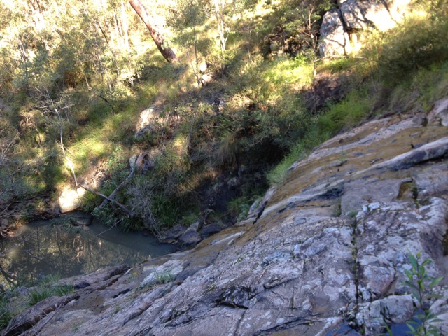
Next stop is the blowholes. Most the southern end of Tongatapu Island south are cliff lines and below them are a secondary, smaller set of cliffs. The crashing of the waves against the lower cliffs sends great waves of spray and water splashing onto the top of them. Over time, holes have formed in the rock plate atop the lower cliffs and as water crashes spray pumps through the blowholes. It’s rather spectacular, especially if the waves strike at an angle, the spray going along the coastline. The blowholes span pretty much the entire of the south side of the island.

wpid-img_0345-2012-07-6-18-44.jpg

We stopped off at Keliti Beach Resort for lunch, and sat on the verandah watching the bow holes out front. There is a beach out front of the resort, with about 5 metres of sand out front. The food was pretty good.

wpid-img_0364-2012-07-6-18-44.jpg

Further down the island, we came to Hufangalupe, also known as the Pigeon Doorway. This is apparently where Maui threw his spear at a pigeon and missed forming a hole in the ground and a natural arch where the water rushes in from the sea. The Irish story is slightly different. This is where St Patrick dug his staff to rid the island of snakes.

wpid-img_0354-2012-07-6-18-44.jpg

Further around the island is Anahulu cave, a stalactite cave that you can walk down into with a pool in the bottom where you can swim. To get it, you duck through a low entry and follow steps cut into the ground. The cave is fairly large and is lit in places by a jury rigged lighting system and dark in others. The pool is quite large. One of the lads in the group went for a swim among the Tongan kids that were there. For T$10 it was worth seeing, even though I didn’t swim.

wpid-img_0371-2012-07-6-18-44.jpg

At the eastern end of the Island is the Ha’amonga Trilithon. A ‘man-made’ structure built about 800 years ago, that on the longest day of the year apparently the light shines through it on a certain angle. It was also used as a calendar. There are still disputes of how it was constructed and like the egyptian pyramids, the great 30-40 tonne blocks were lifted and placed in perfect alignment. How humans did this in those days there is much speculations, but the trilithon stands.

wpid-img_0378-2012-07-6-18-44.jpg

Lastly, on the drive home around the bay, we spied fishing pigs. That’s right, pigs out in the bay fussocking for food. The will eat whatever the can find, sand worms, bugs, small fish, crabs etc. But the can be seen all the way around the bay. Amusing.

wpid-img_0379-2012-07-6-18-44.jpg

This evening I’m off to Friends cafe for dinner with a lady and her sons from the tour. Tomorrow I ferry over to ‘Eua for some hiking and climbing.
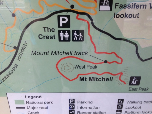
Trail Wanderer

Tongatapu – Day 1

The flight from Brisbane to Auckland was 2 and a half hours, arriving at midnight. With the check in time at 5.45am, there wasn’t many options. My parents live in Auckland, so they came and whisked me off home for the evening where I sat chatting with them through the wee hours until it was time to head back to the airport.

The flight to Tongatapu – another 2 and a half hours – had barely taken off when I lapsed into a well needed sleep. With 30 minutes left in the flight, I awakened to a blanket of clouds below. Shortly after, it cleared leaving blue waters as far as I could see from the plane. Then, within moments, the Island of Tongatapu appeared magically from the great span of blue sky and puffy white clouds.

wpid-img_0313-2012-07-5-14-04.jpg

The roaring waves of the beaches crash against the rocky beaches, but there is not a speck of sand as far as I could see. Palm trees are sprinkled lavishly across the entire island. The International airport is small, as you would expect from a small antisocial set of islands in the middle of the Pacific Ocean, and I met the man who would drive me to my accommodation on the island – Toni’s Guest House.

wpid-img_0320-2012-07-5-14-04.jpg

The weather is warm – for winter, although there aren’t really seasons here. It’s muggy, and coming from a Brisbane winter – where the muggy has gone – it’s good to feel the heat again.

About 70% of the main roads on the island have been sealed, mainly from the Chinese influence in the Kingdom, but the most common site on the trip to the guest house is the Chinese shops along the way, small brick buildings with grills on the from that are filled with all manner of packaged goods. There’s would be one on every street corner, if there were indeed streets to have corners.

Toni’s Guest House is well set up. Several houses alone a dirt road run by an Englishman – Toni – and his Tongan family. The blue room, where I am staying, is a lavish and spacious area to stay. There aren’t many tourists around – they don’t get too many of those here. But even so, all of the rental cars have been taken already – there is a Mormon festival here at present. That is somewhat limiting for what I was intending, but will just go with the for and see how it goes.

wpid-img_0322-2012-07-5-14-04.jpg

Every visit to the island should include the Friends Cafe, supposedly the best place in town to each at a decent price. I’m only here for two nights before moving on, so without a vehicle to move around in, I am dependant on Toni’s tour tomorrow.

wpid-img_0325-2012-07-5-14-04.jpg

This afternoon I went for a walk around the main city of Tongatapu. Small when compared to pretty much any other city in the world, but it’s still quaint. Plenty of markets and the occasional flash building. The city is being rebuilt after it was put to the flame during the 2006 riots.

wpid-img_0327-2012-07-5-14-04.jpg

This island is not know for it’s natural scenery, but am hoping to see some of that which it does exhibit tomorrow on the tour. Until then.. The islands in the bay…
wpid-img_0324-2012-07-5-14-04.jpg

The Cougals – Cougals National Park

The Cougals National Park is a section of the Springbrook National Park on the border of Queensland and New South Wales. It’s a pair of peaks that rise out of the rainforest, rocky and beautiful.  Note, this is different to the Mount Cougal Cascades, which is not connected to the peaks hike.

The East Peak is the most commonly climbed and is a 8.5km return trip with a moderate grade. The West Peak has a hard grade and is a further 750m across a saddle, giving the total hike of both peaks 10km return.

There is no formal trailhead for the Cougals walk. To get to the beginning of the trail from the Gold Coast cross the border into NSW and then back again along a dirt road named Garden Of Eden Road to a gate where there is room for several cars to park. There are local’s driveways nearby, along with a handmade sign announcing the beginning of the walk and demanding hikers to stay on the track.

IMG_0291

The trail heads west along the fence line between QLD and NSW. The fence has barbed wire along it, but whether it is designed to keep the New South Welsh out of Queensland is unknown. The trail climbs uphill through brush with low branches.

IMG_0292

It had rained this last week, so the dirt here was a little slippery. The brush gave way to tall grasses along the trail, which in turn gave way to thin bamboo growths. The grass overhanging the trail sometimes contained thorny branches. I probably should have worn long pants as I sustained many small scratches by the end of the day.

IMG_0293

The grassy path explodes into rainforest with tall trees and the typical Strangler Figs everywhere. The trail follows the fence line, climbing and descending gentle hills. It’s fairly obvious when you reach the first of the Cougals, the trail climbs steeply with dirt and tree root steps making it slippery after the recent rains. While slipping is the ever-present danger, being snagged on the barbed wire makes climbing even more dangerous.  Caution is suggested.

Atop the steep climb, rocky outcrops stand tall above you with dark brooding caves along its face. We walked along the base of the major outcrop until we found our way to a path that climbed through it. The trail up the rocks was obvious as someone had tied a rope to aid with handholds.

IMG_0311

Once above the rope line, it was an easy climb to the top of the East Cougal and fantastic views of Mt Warning to the South,

IMG_0300

…the rocky face of West Cougal to the West, out to the coast towards the city of Tweed Heads out to the East and Springbrook National Park to the North. On this sunny day, the climb was well worth the effort.

IMG_0299

My companion and I did not stay long, however, deciding to push on before lunch. We climbed down to the saddle between the peaks with only one steep troublesome and slightly precarious climb. The trail crossed the saddle, but unable to find a suitable place to stop we proceeded around the great rocky outcrop known as the West peak, looking for an easy path up.

IMG_0303

The West peak looks to be a hard climb with its many rocky faces. We skirted around it passing a couple of rocky climbing places marked with pink ribbons until we found a dirt path through the undergrowth. It was a little slippery but surrounded by plants that gave plentiful handholds. While finding the route up was not the easiest, climbing up it was fairly straight forward.

Unlike the summit of the East peak, which is small, the West Peak has a large area with meandering pathways and what appeared to be a camp site. We stopped for lunch at the fire pit.


IMG_0308

The descent passed quickly, as it always seems to, and before we knew it we were slogging our way through the tall grasses and back to the car.

The Cougals is an awesome hike and I would recommend it to any fit and capable walker. It’s going down as one of my favourites in this region.

The Trail Wanderer.

Mount Mitchell Peaks – Main Range

The Main Range National Park is a section of South East Queensland’s Scenic Rim – a quarter circle of mountains attributed to the prehistoric Tweed volcano that existed here over 23 million years ago. The Main Range is about 115km inland from Brisbane and has plentiful walking tracks along its length.

IMG_0259

This last weekend, while passing through the Main Range, I had a free morning so stopped at Cunningham’s Gap – the location where Cunningham Highway cuts through the mountains. Cunningham’s Gap is the starting point of several well-defined and more casual walks.

IMG_0262

The Major Mitchell Peaks is a 10.2km, 3.5 hour walk, perfect for the time I had. The beginning of the trail starts opposite the car park and meanders its way up the side of the mountain along a forest path.

IMG_0265

The closeness of the forest gives the illusion that the trail is fairly flat, but it’s not.  It’s only the last few hundred metres that the trail begins to climb more steeply, with steps cut into the rock.

IMG_0277

The views to the east are fantastic with the road winding through the forest.  Lake Moogera can be seen between Mt Greville on the right and Mt Edwards.

IMG_0281

To the north, Mt Cordeaux.

IMG_0274

The trail heads back into the forest as it rounds the Western peak and emerges at the top of the Eastern peak, a short pinnacle of rock that’s been paved to prevent further erosion. I basked in the winter sunshine eating lunch with views in both directions.

IMG_0286

I would have stayed longer but the occasional icy gust quickly chilled me. The return walk passed quickly and the tranquillity of the trail was broken by the harsh sounds of trucks going past on the Cunningham Highway.  On reaching the highway, I returned to my car and continued on my trip.

The Lone Trail Wanderer

Mount Tunbubudla East

Glass House Mountains National Park – again.

After spending 3 days wandering the trail of the Glass House Mountains, I’m back to climb one that doesn’t have one.  This time I’m walking with my hiking group and the mountain is Mount Tunbubudla East, a 300m tall, off track climb and is rated hard, mainly due to it being trackless.

Getting to the mountain is a mission in of itself. The old ‘major road’ that it’s off is actually a boggy dirt road and is untraversable without an off-road vehicle.  We parked at the entrance and as a group walked about a kilometre to the muddy starting point. We waited for others to arrive and find us before we headed off into the untracked grass at the base of the mountain.

I led the way, pushing a path through the long grass for the others to follow.  At the beginning there was a vague track, but this soon disappeared. The initial portion of the climb was up tree laden, broken ground. With no track, I had to evaluate each step and find suitable gaps between tree branches.

The climb became steeper before flattening out the higher we got, but because of the thick tree cover we were unable to see the views. As we approached the top we came to a large rocky area which did allow us a better view, north across the other Glass House Mountains.

IMG_0257

We reached the top and sat for lunch at the rocky cairn. I surveyed the route leading towards the West peak but found it too steep to descend. Alone it would have been fine, but with a large group in tow I made the call to return the way we’d come. This disappointed some, as the climbing down in that direction would have led to the climbing of the smaller,  steeper twin.

IMG_0256

The climb down held the same issues as the climb up – a lack of trail – and it’s also harder to see where you’re putting your feet. I again led, picking our way down the side of the mountain. We arrived at the base in short order and walked across the needle covered grass until we reached the muddy road. We could have climbed the other peak, but the mutual decision was not to. A kilometre later we were at the cars and headed off for a well-deserved beer at the Beerwah Hotel.

Trail Wanderer

D’aguilar National Park

16 June 2012

Rainforest Circuit, Cypress Grove and Greenes Falls.

Maiala

Maps on this page are owned by and used with courtesy of Queensland Government.  Please visit that site for more detailed information on hiking in this region.

While I much prefer harder and rockier walks, there were several walks in the D’aguilar National Park that I had on my list to do. D’aguilar National Park is mainly forest, so it’s trees, trees, trees, and the tracks are well-defined and not terribly difficult.

IMG_0228

To cross them off my list, I headed out with a friend to the Mt Glorious section and walked into the rainforest. It was an entertaining walk in the cool morning air, with large strangler figs in many places.

IMG_0224

The Rainforest Circuit and Cypress Groves were fairly standard fare. Greenes Falls was a great place for a sit down and a chat.

IMG_0236

The falls are fenced off, but this didn’t stop me from climbing the fence and rock hopping down to the edge of the falls.

IMG_0240

Western Window Track

Across the road from the Cypress Grove walks is another tree laden walk along the side of a steeply sloping cliff.

IMG_0246

Morelia Walking Track and Atrax Circuit

manorina

Another slow meander through the forest, climbing fallen giant eucalypts and walking through great burnt out trunks.

IMG_0254

The trail eventually led to the Mount Nebo lookout, and while there is only a limited viewing area, Moreton Bay is visible in the distance.

IMG_0247

Overall, the trails in the D’aguilar National Park aren’t very taxing, but if you enjoy walking in the woods, this is a good place to spend a few hours on a warm sunday afternoon.

The Lone Trail Wanderer

Mooloorah River NP, Dularcha NP, Tibrogargan Circuit

Today was my third day walking in Glass House Mountains.  On Day One I climbed Mt Ngungun and Mt Beerburrum, while on Day Two I climbed Mt Tibrogargan and Wild Horse Mountain. Today I won’t be climbing any of the mountains, instead walking several of the other short walks in and around the Glass House Mountains.

Mooloolah River National Park, Jowarra Section 1.5km

Mooloolah River National Park maps

Map is owned by and used with courtesy of Queensland Government.  Please visit that site for more detailed information on hiking in this region.

There are two short tracks in the tiny Jowarra Section of the Mooloolah River National Park and together they are only 1.5km long.  They are both only class 2 with concrete tracks and no climbing at all.  It was a cool morning when we arrived and much of the beauty was in the mists that hung about trees.  The two simple loops took little time to walk and before we knew it we were back in the car and off to Dularcha National Park.

IMG_0199

Dularcha National Park – 4km

The main draw card for the Dularcha National Park is an old railway tunnel about half way along the trail.

IMG_0201

The trail is wide and easy to follow as it runs alongside the new railway tracks.  Horses and cyclists regularly ride along the trail and while here we saw two different families on their bikes.  This class 3 trail rose and fell slightly as we walked but remained fairly flat.  While not a difficult walk I did break a sweat but more from the direct sunlight than how strenuous the trail was.

IMG_0204

The train tunnel was pretty cool, although was only fairly short.  There are reportedly micro bats living in this tunnel which I was keen to see, but we didn’t find any.

Dularcha National Park map

Map is owned by and used with courtesy of Queensland Government.  Please visit that site for more detailed information on hiking in this region.

The track is linear and after 2km you’re required to walk back along the same trail to the beginning.  On reaching the car, my companion waved the white flag, so I dropped him home and set off alone to do the last couple of more difficult tracks.

Tibrogargan Circuit and Trachyte Circuit – 7.3km

I climbed Mt Tibrogargan on a previous foray into the Glass House Mountains, but around the base of the mountain are a pair of tracks that when joined together are over 7km long.

Glass House Mountains walking track information and maps

Map is owned by and used with courtesy of Queensland Government.  Please visit that site for more detailed information on hiking in this region.

The Tibrogargan circuit (‘a’ on the above map) leads around the mountain to a T-junction where one branch heads back to the car park, the other is where  Trachyte Circuit (‘b’ on the above map) begins, cutting across the valley towards Mt Tibberoowuccum to a lookout before returning to the car park.  The trails are class 3 and class 4 respectively with a short climb to the lookout on the Trachyte Circuit.

IMG_0209

The views from the trail consist mainly of trees with the occasional creek crossing.  I stopped in several places to peer through the trees at one of the neighbouring mountains, but most did not give clear enough views to take photos.

IMG_0210

The most difficult part of the walk was the 100m section up to a Tibrogargan Circuit, where I chatted to some English tourists about New Zealand.

IMG_0211

The remainder of the track was fairly gentle and after a total of about an hour and a quarter I returned to the car park.

It was a good day of walks on Queensland’s Sunshine Coast and while I hadn’t planned any further walks in the Glass House Mountains National Park, my hiking group had other ideas. In a month they plan to climb the Tunbubudla Twins, a pair of small peaks at the southern end of the National Park.

Next I head to The Cougals for something more difficult hard to dig my teeth – or feet – into.

The Lone Trail Wanderer.

D’Aguilar National Park – Mt Coot-tha section

Mt Coot-tha is the tallest ‘mountain’ in Brisbane and is popular with tourists as its top lookout gives great views of the city and surrounding land.

20140403 - Mt Coot-tha Forest Park track map-2

Map is owned by and used with courtesy of Brisbane City Council.  Please visit that site for more detailed information on walking in this region.

I’ve been to the lookout numerous times and have walked the lookout trail a couple of times also. On the northern slopes of Mt Coot-tha there are several less popular and less scenic walks I decided to explore.

Powerful Owl Track – 2.8km

IMG_0185

Powerful Owl Trail is a short track that climbs the north side of Mt Coot-tha.  Initially I was expecting a fairly straightforward walk in the woods, but shortly after beginning I got quite a surprise.  Not far after the beginning the trail turns quickly upwards  and climbs fairly steeply.  It certainly gets your muscles working and my calves felt it when I arrived at the top of the ridge.

IMG_0186

At the top of the ridge I followed the trail around to the left, through the forest until it began to descend down mud and roots steps.  After the steady downhill it didn’t take me long to emerge at a grassy reserve just around from the car park.

IMG_0188

Overall a good short walk although beyond the trees, not much to look at.

Simpson Falls and Eugenia Circuit – 4.1km

Beyond the Lookout Walk, the Simpson Falls circuit is one of the more popular on Mt Coot-tha.  It’s for this reason the trail leading to the falls is well presented and designed for casual walkers.  The trail climbs in switchbacks up the north-east side of the Mt Coot-tha with plentiful steps.

IMG_0193

Simpson Falls is a quaint little rocky area that during a wetter season would likely be more than just a trickle with small rock pools at the top and bottom of the rocky outcrop.  This was to be expected as it had been plentifully dry around the time I walked here.

IMG_0197

The Eugenia Circuit continues another 2.8km up the mountain from the Simpson Falls.  The path turns rockier and is less walked, crossing the stream twice on stepping-stones.  At a couple of points on the track I could make out suburbia over the trees, but no grand views.

IMG_0196

There was one other track I did not make it to – the Kokoda Trail, named after one of the men who walked the actual Kokoda trail.

The Lone Trail Wanderer.

West Canungra Creek Circuit – Green Mountains

Lamington National Park: Green Moutains section map

Map is owned by and used with courtesy of Queensland Government.  Please visit that site for more detailed information on hiking in this region.

Today I’m out with my hiking group from meetup.com.  Meetup.com is a great way to find hiking groups in your area and they often go to many interesting places.  The downside of meetup.com groups is they tend to attract larger groups of walkers and can be more about being social than the experience of being out in nature.

IMG_0148

This time we headed into the Green Mountains section of the Lamington National Park to do one of the many circuits.  This is also where I began the Gold Coast Hinterland Great! Walk only three weeks earlier.  The hikes start at the same location and use about a kilometre of the same trail before splitting off and going their respective directions.

IMG_0150

The West Canungra Creek circuit has a Class 4 rating but I believe this is only when it is wetter.  Because it was pretty dry and the streams were down,  the crossings were easier and the rating should only be a Class 3.

IMG_0153

The circuit is 13.9km long and meanders down towards Canunga Creek.  It then heads along the stream, with several crossings towards to “Yerralahla” (blue pool).  There were plentiful small waterfalls, downed trees, rocky outcrops and stream beds along the way.

IMG_0170

About half way around the circuit, the track forks, eventually meeting up again a couple of kilometres along.  At the fork I decided to take my leave of the group to get a bit of time to myself in nature.  As I walked I came across a pair of large waterfalls.

Yanbacoochie Falls…

IMG_0178

Elabana Falls…

IMG_0182

I met up with the group again when the trails reconnected.  We continued our way back along towards the end of the circuit, crossing a treetop walk on the way back.

IMG_0184

Overall an interesting walk and talk, I got to speak at length to a guy from Chile about South America, the starting place of my big adventure next year…

Next week, I wrap up the Glass House Mountains and do a couple of short walks at Mount Coot-tha.

The Trail Wanderer.

Glass House Mountains – Mt Tibrogargan and beyond

I’m back this week to climb more of the Glass House Mountains.  Last week I managed both Mt Ngungun and Mt Berrburrum and this week I try for two more, Mt Tribrogargan and Wildhorse Mountain, as well as wandering around the base of Mt Beerwah and the Glass House Mountains Lookout. I would have liked to have climbed Mt Beerwah as it’s the tallest of the Glass House Mountains, but due to a landslip it’s closed.

Mt Tibrogargan

IMG_0097

I had some trepidations about climbing Tibrogargan as it’s listed as a Class 5 with some scrambling and steep rocky faces, but it’s on the list so I wanted to do it.  I set out with a colleague and we drove to the Glass House Mountains.  Mt Tibrogargan is one of the more prominent of the mountains and is said to look like an ape.

IMG_0113

The walk to the base is along a fairly standard gravel path that turns rocky and begins to climb slowly towards the base.

It’s not long before Tibrogargan appears out of the trees and you are confronted by the first rock face.  It’s literally climbing rock face after rock face all the way to the top.  There are no nice steps formed in mud and tree roots, it’s all rocky.  It’s not so steep that rock climbing gear is required, but definitely not for the faint hearted.

My companion felt discouraged early and chose to return to the bottom, which is understandable, as it’s a daunting prospect.  I, however, pushed on.

IMG_0107

There were some points on the way up where I felt nervous, but I didn’t let them hold me back and kept climbing.  The views were good on the way up, but you don’t spend much time looking around while climbing.

IMG_0105

At the top, there’s plenty of scrub and the views aren’t so apparent.  I did get the odd photo, but compared to Mt Ngungun the view is mainly hidden behind trees.  At the top I ran into a woman fossicking in the bushes.  Apparently she was looking for a geo-cache – a box someone has set here at a certain GPS location.  I fossicked in the bushes with her for a while looking for it but after a while we gave up and climbed back down.

Glass House Mountains walking track information and maps

Map is owned by and used with courtesy of Queensland Government.  Please visit that site for more detailed information on hiking in this region.

It was good to have her along as she’d done this climb on many occasions and gave me guidance on the best way down.  She also told me about the aboriginal history of the Glass House Mountains.  Then at the bottom, I bid her farewell, collected my companion and we headed off to the next mountain.

Wild Horse Mountain

Compared to Mt Tibrogargan, Wild Horse Mountain is a molehill.  A 700 meter path up to a look-out.  A woman on the way down commented how much easier it was coming down.  If only she knew that we’d just come from Mt Tibrogargan.  And honestly, getting out of bed that morning was more difficult than climbing Wild Horse Mountain only because it was a little chilly getting out of bed.  As for Wild Horse Mountain, I wasn’t expecting much of a climb.

IMG_0116

It was as easy as expected and didn’t take us long to reach the lookout at the top.  The views are nothing short of spectacular.  You can see all the Glass House Mountains, the scenic rim and out to the sea on the other side.

IMG_0118

Glass House Mountains Lookout

The Glass house Mountains Lookout is at the western end of the Glass House Mountains and while not actually climbable, it does have an 800m bush walk through the forest.  In general the views were not a good as those from Wild Horse Mountain and there wasn’t much to see along the walking trail.

IMG_0124

Mt Beerwah

To cap off the day we drove to the base of Mt Beerwah, passing the unclimbable Mt Coonowrin.

IMG_0129

Mt Beerwah is more daunting than Mt Tibrogargan, but due to a rockslide that has blocked the path it was deemed too dangerous and closed.  As the tallest mountain in the National Park it would have been nice to have climbed it.  I’m told it is a similar experience to climbing Mt Tibrogargan.

IMG_0132

There were several more walks in the Glass House Mountains I wanted to do and came back twice more to complete them.  Details can be found here: Mooloolah River, Dularcha NP, Tibrogargan and Trachyte Circuits and Mount Tunbubudla East.

The Lone Trail Wanderer.