Tag Archives: National Park

The Pinnacles Loop Track, Coromandel – New Zealand

After a day walk in the Karanagahake Gorge, I headed to Thames, a 115km from Auckland, to prepare for an overnight hike to the Pinnacles in the Coromandel Forest Park. While a large portion of it is in the forest, there is a good portion in the tussocks above it too, so I will let it go. The mid-March weather also continues to hold up.

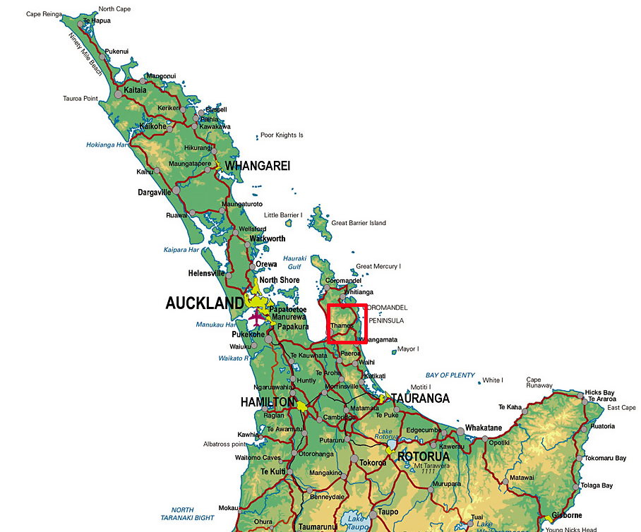
The Pinnacles Loop is a 17.2km trail amalgamating three trails, The Kauaeranga Kauri Trail to the Pinnacles hut, the side trail to the top of the Pinnacles themselves and the return walk on day two along the Billygoat Walk. While 17.2km is around my average walking distance on a typical day on my multi-day hikes, I’m stretching it out over two days as I want to stay at the Pinnacles Hut.

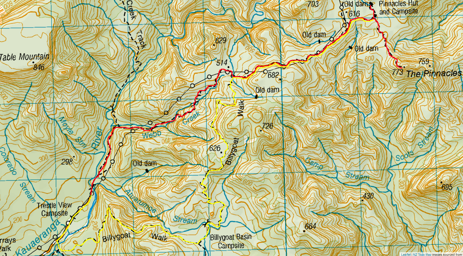
Day 1 – Kauaeranga Valley Road End to Pinnacles Hut – 6km – 3 hours + side trail to Pinnacles Summit (2km – 1.5 hours)

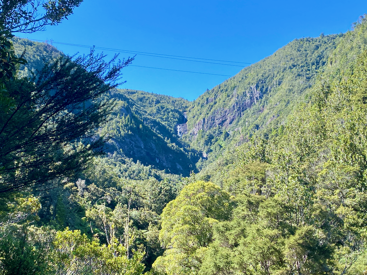
I headed out from the carpark at the end of Kauaeranga Valley Road, through the boot clearing station and onto the rocky trail. There is an epidemic of Kauri Dieback disease in New Zealand, and one of the defences is to clean boots before and after walking in Kauri forests, and thus there are boot cleaning stations everywhere. A few minutes in, I followed a short side trail to view the Billygoat Falls. They are distant and small, but caused loggers in the early 1900s much trouble.

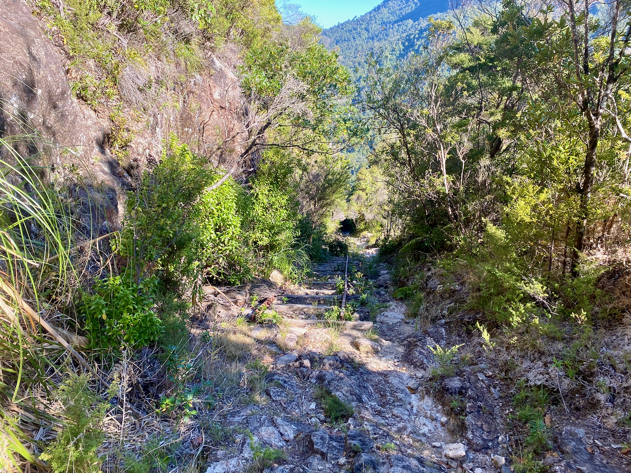
I continued along Webb Creek as the trail began to climb steady on a rock and dirt trail with steps cut into it in many locations. These steps were often build with branches or chiselled out of the stone. This was to help the the pack animals climbing the trail and hauling logs back down again.

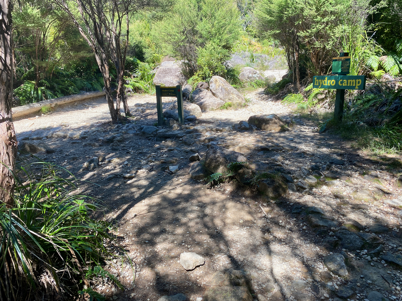
Much of the 400m total ascent occurs during the first 3km with the trail, crossing the creek several times either by rock hopping or on small bridges. On several occasions there were flood trails for those days when the creek is unsafe to cross due to high water levels, but today it was very low. After two hours in the forest, I came out at the Hydro Camp, a flattened areas which is the junction on the trails. I paused for a break and took my boots off in the sun.

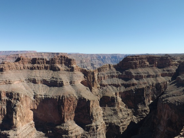
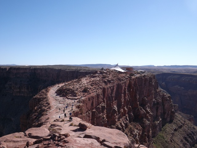
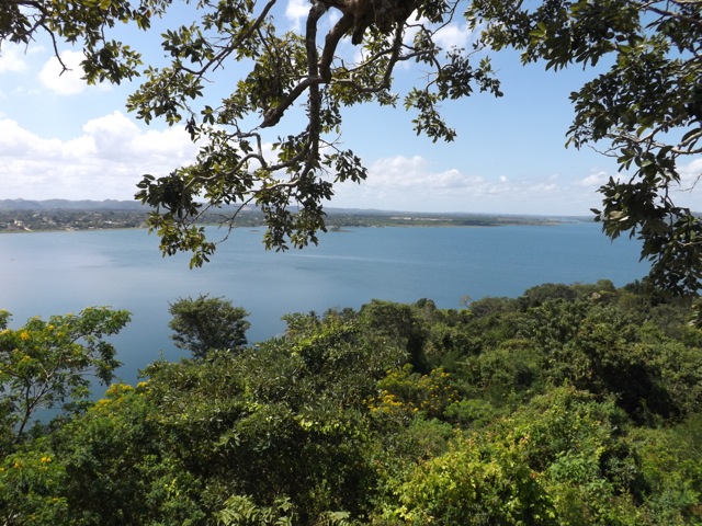
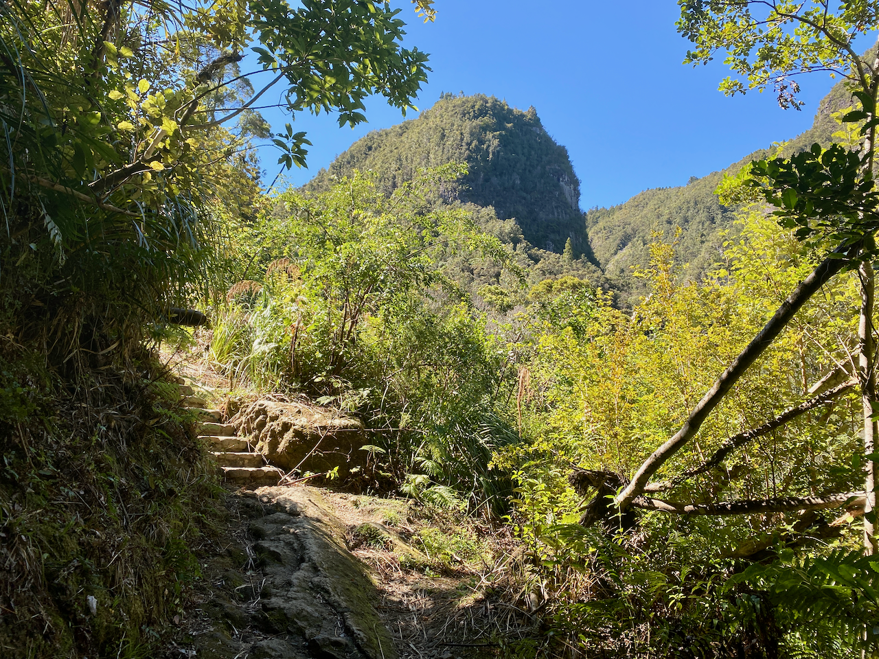
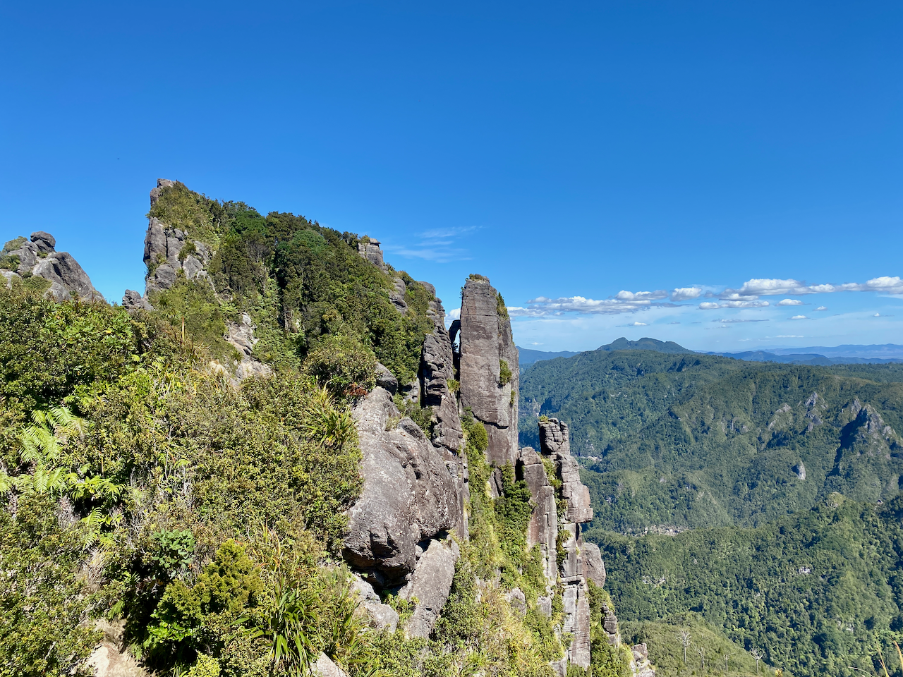
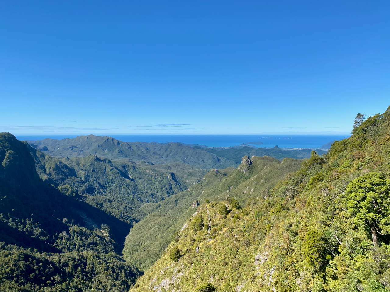
From here the tall tussock begins giving more access to the sun and the views. This entire region was created by volcanic activity over the past 20 million years, with the bluffs and pinnacles acting as rocky plugs of the long extinct volcanoes.

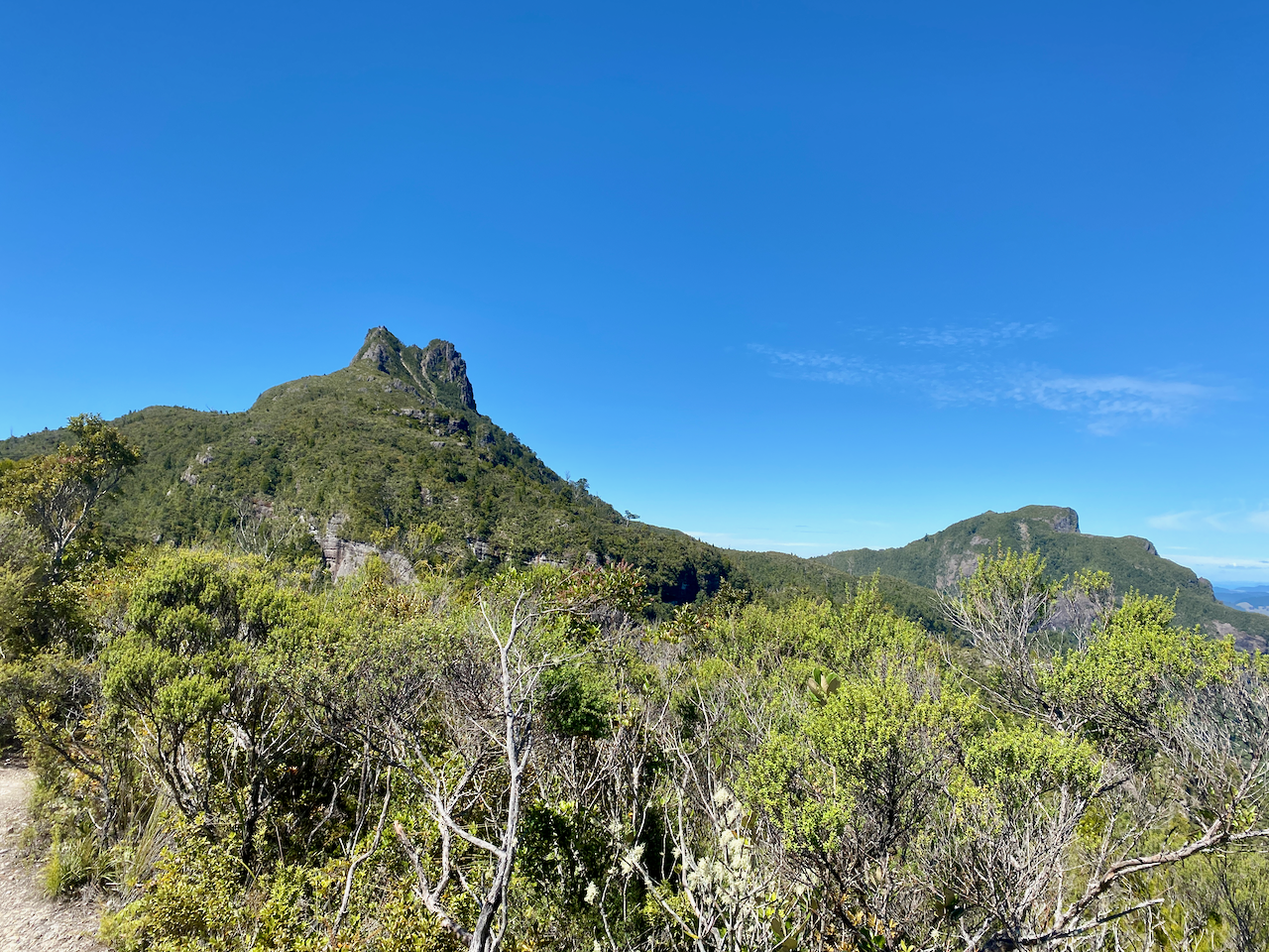
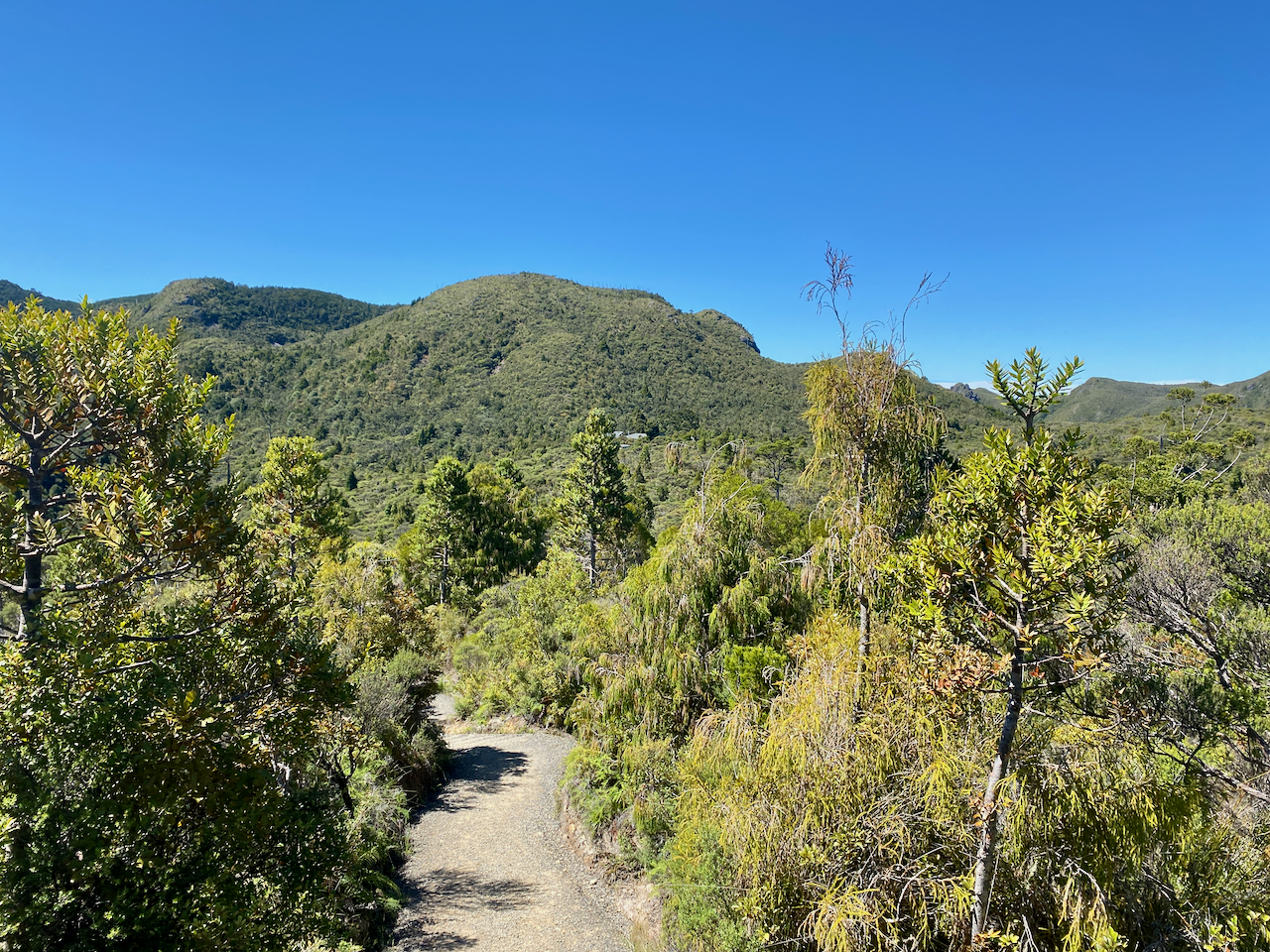
The path grew drier and wider and after another hour, I came over a knoll to see the hut. I proceeded to it and dropped my pack. It was only 2pm and the sign left by the warden said he’d be back at 3.30.

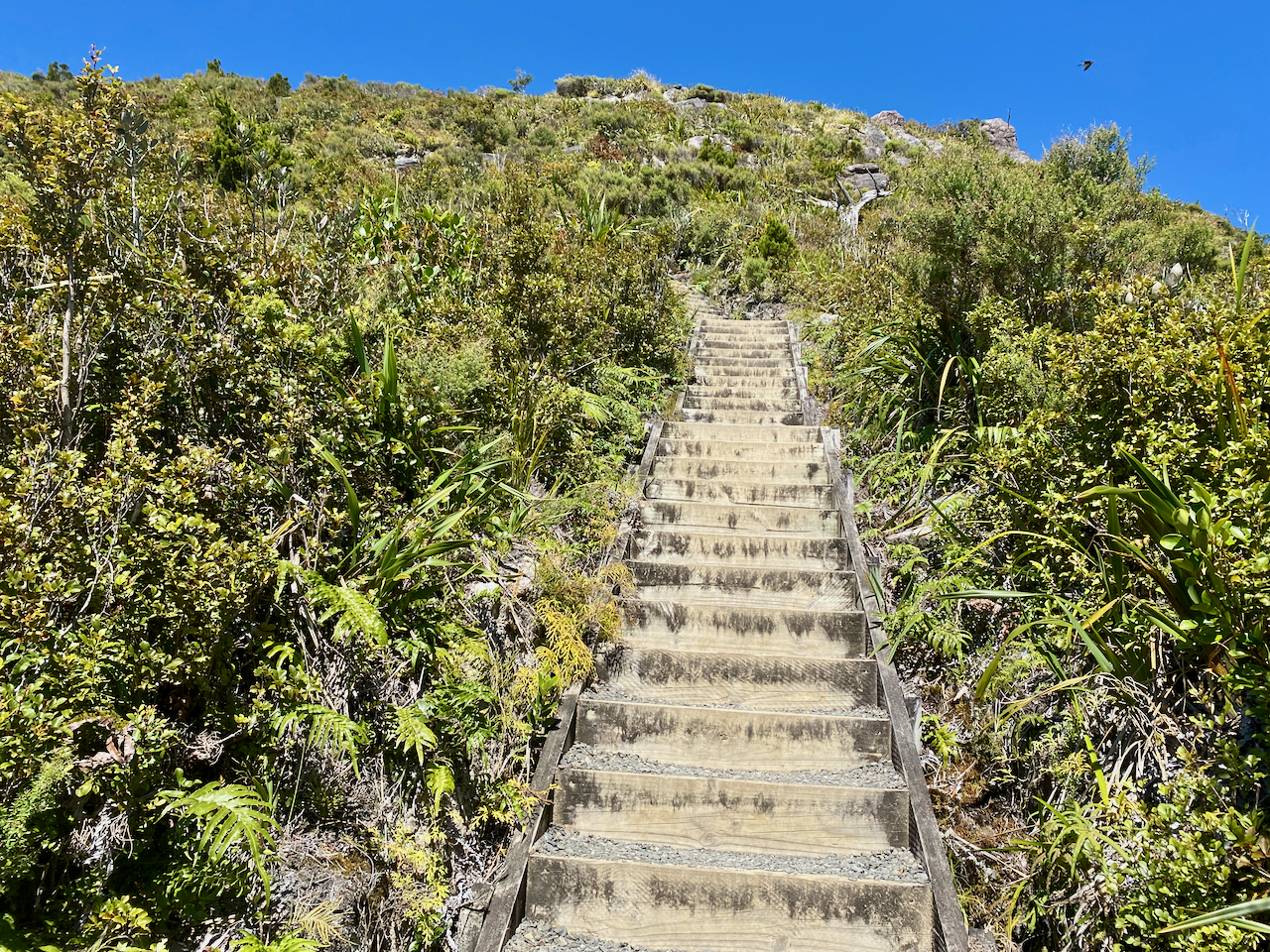
I took a break, had a look around, filled my water bottle, then with only my lighter daypack, headed towards the Pinnacles themselves on a manicured path. The sign says it’s a 50 minute climb to the top.

To make the climbing easier, there are a large number of stairways climbing up to the first of the pinnacles.

But the views from this lower one was still good.

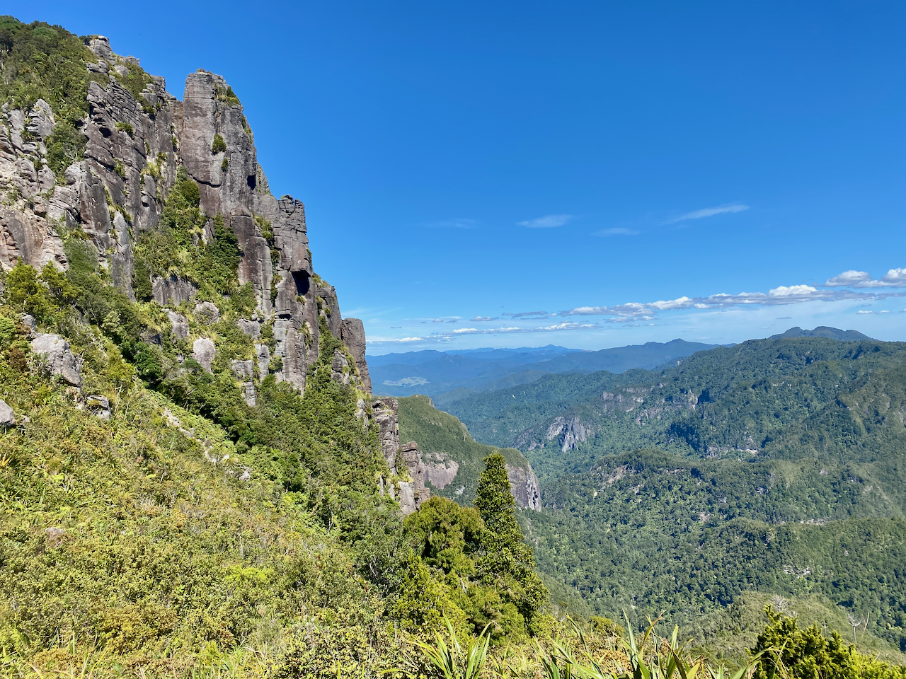
After this pinnacle, permanently installed ladders replaced the stairs. And in several locations, bars of metal have been pounded into the rock to be used as steps in areas where the rock scrambling grew more difficult.

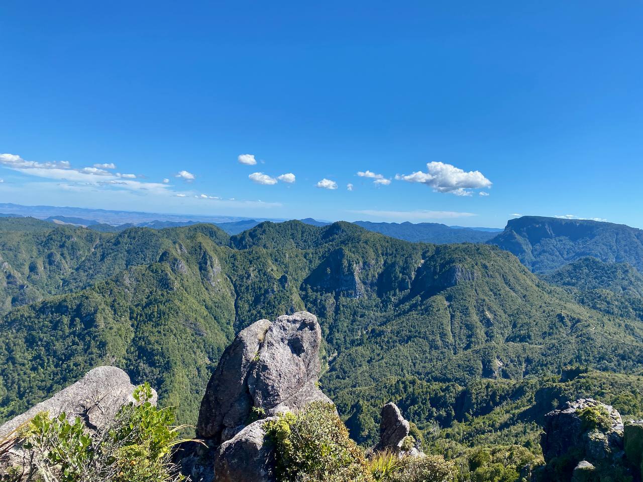
While I didn’t find the climb particularly difficult, the views in all directions were well worth it.

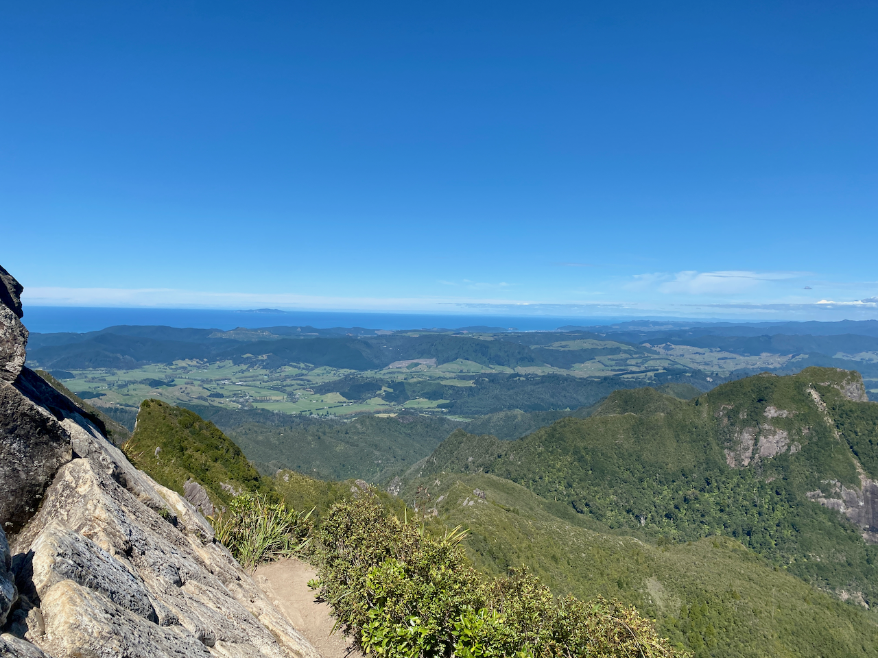
And from this height, the towns of Pauanui and Taurui come into view on the Bay of Plenty coast.

I spent some time alone at the top enjoying both the sunshine and the views, before I made my descent. Coming down was quicker, and when I arrived back at the hut, went straight past to the nearby Dancing Creek Dam, which has been rebuilt to show what the original dam once looked like.

The Pinnacles hut can accommodate a total of 80 people, but there were only 13 booked for the night I stayed. The kitchen area is large and has gas burners and electric lighting. Many of the people in the hut came later than me, arriving close to sunset. As it is only an overnight walk, the wine bottles appeared from packs after dinner. This also meant that people were coming to bed later and making more noise.

Day 2 – Pinnacle Hut to Kauaeranga Valley Road End via Billy Goat Walk – 7km – 2.5 hours
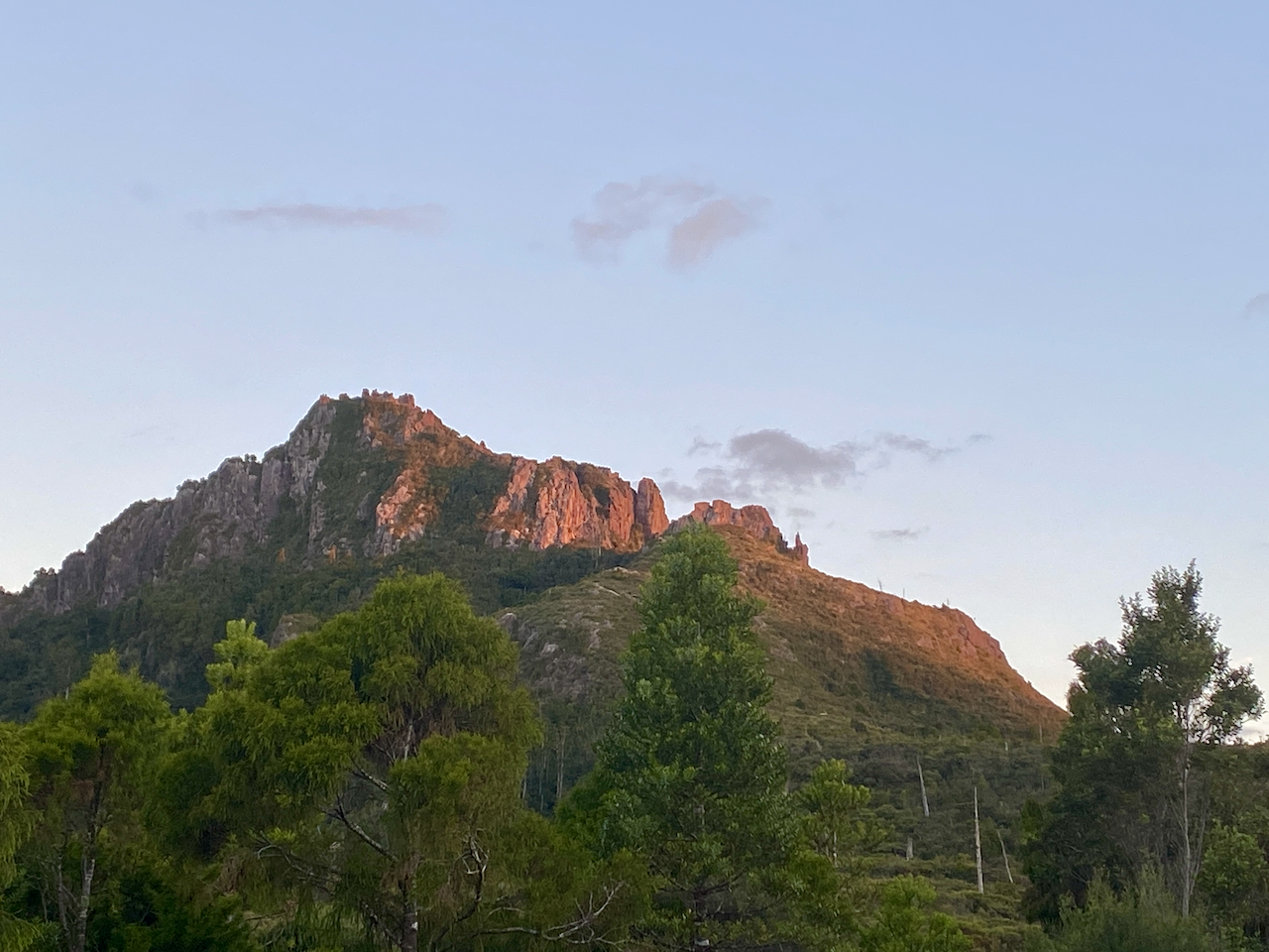
All of the late comers from the evening before also decided to get up early to meet the sunrise at the top of the pinnacles, so the noise began again. And once I’m awake, I find it difficult to get back to sleep again, so I got up. I moved all my stuff into the dining area in the dark, as I watched the light begin to brighten the sky. I made breakfast and began packing waiting to see the fresh pink sunlight on the Pinnacles.

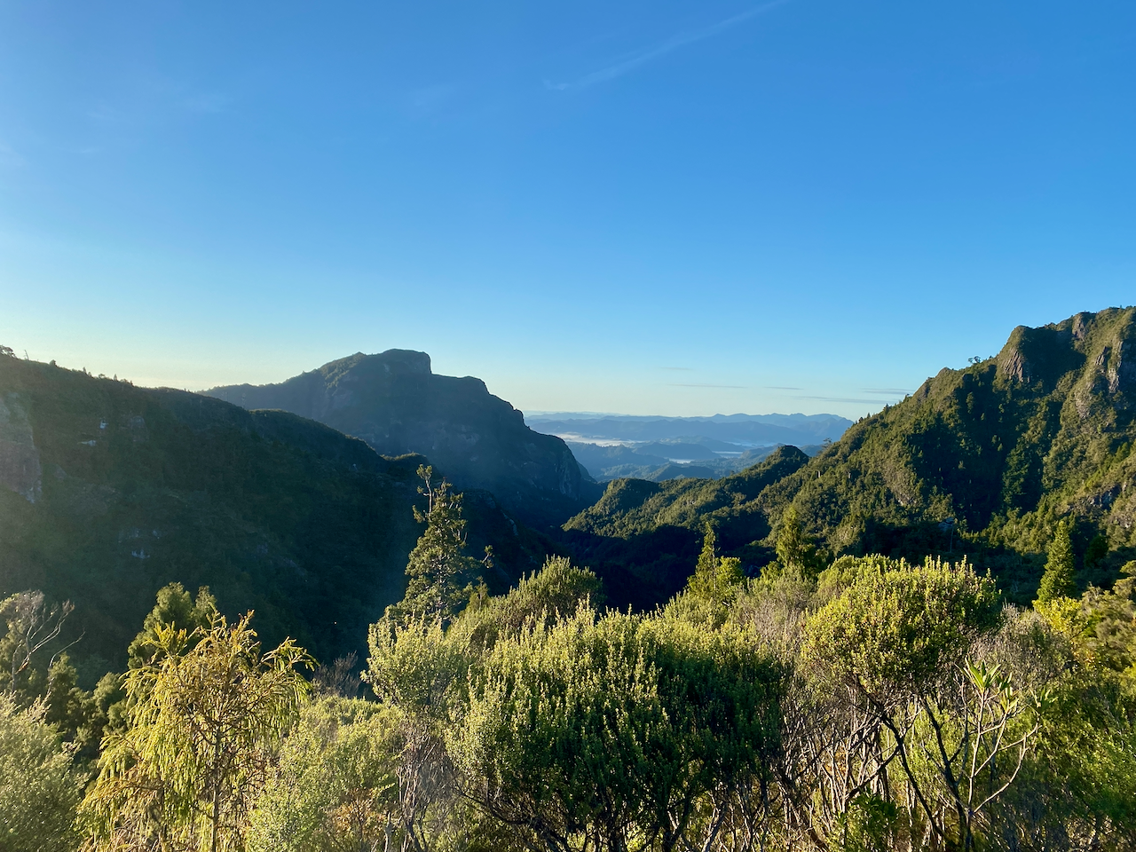
Once I was ready, I made a quick march from the hut back across the trail to the the Hydro Camp where the trail split and I barrelled on down the the Billygoat Walk trail. For a handful of kilometres, the trail undulated with several dips and climbs but always seeming to come back to a similar height, until it didn’t anymore, and the main descent began. In the trees, there was little to see as I came down, with similar steps in many places cut from stone, branches or packed dirt. Eventually I came out at the Billygoat Campsite where I had a brief chat with an American girl who was packing up her tent. I continued on and the main steep descent began. I got a good view down the valley as I went, some mist still hanging on the hills in the distance.

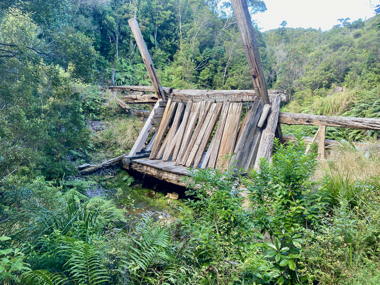
I came past an old tramline a couple of times, the higher end once held the engine which moved very little, but using tow cables, it lowered and raised cars laden with logs and equipment.

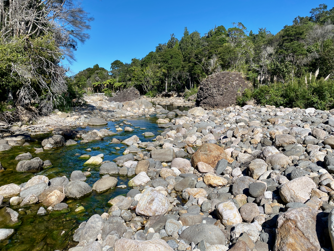
The slope continued its steepness, and I pushed on down it for nearly a kilometre until it finally came out at the Kauaeranga River, which thankfully was not running strong at this point. I rock hopped across and came out on Kauaeranga Valley Road 300m from the carpark. Not long after, I arrived and dropped my pack.

Overall,
While a good portion of the walk was in the forest, it was short enough to not set off my annoyance and the views above the forest line were excellent. It was a short walk, and I could have easily done it in a single day, I enjoyed getting away from civilisation for the night.

With the weather packing up for the next couple of weeks, I’m back to the gym hoping to get a clear week at the beginning of April for an early autumn walk at the end of my walking season before I begin my winter hibernation.

Until next time,
The Lone Trail Wanderer.

George Town, Malaysia – Impressions

George Town is a city at the north-eastern corner of the Malaysian island of Penang. Named after the British King George III, the island was leased to a British trade boat captain in exchange for protection from the Burmese and Siamese armies. The captain, however, had no intention of fulfilling the lease and instead set up George Town as a trading port.

wpid-malaysia-penang-2014-12-6-21-23.jpg

While the island is commonly reached by ferry from the mainland for less than a dollar, it is reachable by road via a pair of bridges. Penang bridge is 13.5km long while the newer Penang 2 bridge is 23.5km. George Town has several long waterfronts adorned with hotels and shipping yards.

wpid-dscf5875-2014-12-6-21-23.jpg

Street Art
Like most other major cities in Malaysia, George Town’s streets are littered with art. In 2012 the city announced a street art project for the annual George Town Festival. Now there are more than 100 pieces on walls across Old City. Some pieces were created by Ernest Zacharevic, the famous Lithuanian artist responsible for other works across Malaysia.

wpid-dscf5815-2014-12-6-21-23.jpg

While some of the art is in the form of murals, often with a cat theme, other pieces use props. One of the more famous pieces includes a bicycle set against a plastered wall with a pair of children painted to look like they’re riding it.

wpid-dscf5817-2014-12-6-21-23.jpg

Since the festival, wrought iron comic designs have also begun appearing around Old City.

wpid-dscf5807-2014-12-6-21-23.jpg

Penang Hill
Penang Hill is the tallest hill on the island and is one of the most popular tourist locations. At 883 metres, it gives amazing views over George Town, the coastline and mainland Malaysia.

wpid-dscf5848-2014-12-6-21-23.jpg

The easiest way to get to the top is by funicular train, a train operated from top and bottom by cable. Near the top the train passes through a brief tunnel, noted as being the steepest train tunnel in the world. While the ascent is fairly sedate with the training chugging up the hill, the descent can be quite exhilarating as it races towards the bottom.

wpid-dscf5853-2014-12-6-21-23.jpg

At the top there is a double story food court, several private restaurants, an owl museum, a mosque and a hindu temple.

wpid-dscf5840-2014-12-6-21-23.jpg

Penang National Park
The smallest national park in Malaysia, Tama Negara Pulau Pínang, is in the very north-west of the island, about 13km by road from George Town. There are several ways to get to the national park, by tour bus, local bus, car or as we did, by scooter. We couldn’t help ourselves, we enjoy riding them.

wpid-dscf5855-2014-12-6-21-23.jpg

While the park is small, it does have several longer trails, the longest being 6km. There are many species of animals in the park, including two different species of monkeys. This cute but cautious girl is a Spectacled Leaf Monkey.

wpid-dscf5869-2014-12-6-21-23.jpg

With rain imminent when we arrived, we decided to only take a short walk to the Canopy Walk, about 20 minutes along the trail. The Canopy Walk stretches for 250m through the tree tops. Unfortunately, when we arrived it was closed. So we walked back through the forest and along the waterfront to the scooters before heading back across the island.

wpid-dscf5868-2014-12-6-21-23.jpg

Fort Cornwallis
As part of the lease for Penang Island, the fort was built to protect the island from pirates, the Siamese and the Burmese, but it never actually saw battle. The grounds of are now used as concert venue.

wpid-dscf5859-2014-12-6-21-23.jpg

The cannon barrels that remain on the walls are sometimes used by locals as a fertility charm. If flowers are left by barrels it’s supposed to help an infertile woman get pregnant. I guess size does matter when it comes to cannons…

Kek Lok Si Temple
On our way to Penang Hill we spied a very large temple at its base. On our final morning in George Town and with a few hours left of our scooter hire, we headed inland to check it out.

wpid-dscf5879-2014-12-6-21-23.jpg

Ken Lok Si, meaning Temple of Supreme Bliss, is said to be the largest buddhist temple in South East Asia. At the temple entrance there are lines of shops, restaurants and a turtle pond, a buddhist tradition. The main Pagoda is built in three distinct architectural styles, the lower third is Chinese, the midsection Thai and the top Burmese.

wpid-dscf5902-2014-12-6-21-23.jpg

On the hill above the temple, up a 100m skylift, is a 30m tall bronze statue of Kuan Yin, the Goddess of Mercy.

wpid-dscf5893-2014-12-6-21-23.jpg

Overall, George Town has a modern feel about it and is set up both for locals and tourists alike. The Old Town does have a more closed-in feeling, with thin streets and many hostels and guesthouses.

Next we catch a ferry to Langkawi, the Jewel of Kedah.

The Trail Wanderers

Mapping My Journey So Far

Sixteen months on the road is a long time. During that time I covered quite a distance and did many things. While I’ve been ‘resting’ in the United Kingdom, I’ve put together a step by step rundown of my trip including maps.

South East Australia

wpid-seaustralia-2014-05-8-14-57.jpg

In a van called the Pointy Brick I…

Antarctica, Chile and Argentina

wpid-southernsouthamerica-2014-05-8-14-57.jpg

From Brisbane, I flew to Auckland and spent 3 weeks with family before flying to South America where I…

Brazil, Bolivia, Peru and Ecuador

wpid-northernsouthamerica-2014-05-8-14-57.jpg

From Buenos Aires I…

Colombia, Central America and Mexico

wpid-centralamerica-2014-05-8-14-57.jpg

From Ecuador I…

The Full Map. May take some time to load.

wpid-ajtravelmap3-2014-05-8-14-57.jpg

The World Wanderer

Hoover Dam and The Grand Canyon, Arizona – Impressions

Las Vegas, in the state of Nevada, is an intense place even if you’re only staying a couple of days. But if you’re planning to stay a week or more, getting out of the city should be a high priority. We did just that, hiring a car and driving to two features of the region:

Hoover Dam
Hoover Dan is situated on the U.S. state border of Nevada and Arizona, 50 kilometres from Las Vegas. The dam was built in Black Canyon on the Colorado River to prevent flooding, provide irrigation and generate power for the states of Nevada, Arizona and California. At the time of construction it was the largest concrete structure in the world.

wpid-dscf4457-2014-03-20-06-51.jpg

Completed in 1936, the dam was also used as a major highway, but due to increasing traffic concerns the Dam Bypass Bridge opened in 2010.

wpid-dscf4456-2014-03-20-06-51.jpg

The dam created Lake Mead, the largest reservoir of water in the United States by volume. The dam took only 5 years to build and during that time took the lives of 112 people. Sixteen people died in the first year of construction when temperatures in the area clocked in at close to 50ºC. Another forty-two died from pneumonia, although in later years this listing was seen as a cover-up of deaths caused by carbon-monoxide poisoning.

wpid-dscf4459-2014-03-20-06-51.jpg

The Grand Canyon
Nearly 200 kilometres from Las Vegas by car is the site of the Grand Canyon Skywalk. The Skywalk is near the western end of the canyon at a site ingeniously called Grand Canyon West. There are several sections tourists can visit at Grand Canyon West; one is  Eagle Point, named after the impression of an Eagle in the ridge opposite…

wpid-dscf4469-2014-03-20-06-511.jpg

Eagle Point is also the location of the Skybridge itself, a metal framed ‘bridge’ with a glass bottom. Unfortunately use of personal cameras on the bridge is not permitted, meaning the cost of entry onto the walk plus purchase the photographs is quite expensive. Taking the Skywalk is not required as fearless tourists can walk to the edge of the canyon beside the structure.

wpid-dscf4473-2014-03-20-06-511.jpg

Another point of interest is Guano Point, literally ‘Bat Shit Point’. Bat caves were discovered in the canyon, the guano being a good source of phosphates used in farming. The mining lift building still stands at the end of the point.

wpid-dscf4490-2014-03-20-06-511.jpg

Guano Point is at the end of a thin section of a ridge line stacked high with boulders, giving great views along three separate sections of the canyon.

wpid-dscf4499-2014-03-20-06-511.jpg

The Colorado River formed the Grand Canyon over the course of two billion years. It is 446 kilometres long, 29 kilometres at its widest and is 1,800 metres deep. It is in the top five largest canyons in the world, although the term ‘largest’ can have several meanings relating to depth, width and length.

While many simply bus to the sections of the canyon, boat, helicopter and small plane tours are available for those who wish an even closer look.

wpid-dscf4494-2014-03-20-06-511.jpg

Other Places
These are not the only getaways near Las Vegas, only the two we visited. Other sites of interest are:

  • Red Rock Canyon
  • Death Valley
  • Valley of Fire
  • Hidden Valley
  • El Dorado Canyon

The World Wanderer

Cancún and Playa del Carmen, Mexico – Impressions

The ultra touristy Cancún at the tip of the Yucatán Peninsula is the final destination of my three-month whirlwind tour of Central America and southern Mexico.

wpid-487303-mp0404twoweeks-2014-03-19-23-30.jpg

Cancun’s main tourist area is Isla Cancún and was created in the mid 1970s by the Mexican government. The island is actually part of the second largest barrier reef in the world, stretching 1000km from the tip of the peninsula along the entire length of Belize to Honduras. Cancún is renown for being one of Mexico’s two most famous resort cities, the other being Acapulco on the Pacific Coast.

wpid-800px-cancun001-2014-03-19-23-30.jpg

As Cancún was my final destination, I didn’t spend a lot of time exploring the city, instead preparing for my imminent departure. But I did take a day out to travel an hour along the coast to the popular tourist beach, Playa del Carmen.

wpid-dscf4270-2014-03-19-23-30.jpg

It’s easy to see why the beach town is so popular, the golden sandy beaches and clear blue waters are beautiful. And while the beachfront restaurants and resorts are numerous, they’re not as all-encompassing as those in Tulum, and hour further south.

wpid-dscf4267-2014-03-19-23-30.jpg

It’s been a long adventure through Latin America these past thirteen months but I’m ready for a well-earned rest. While the constant traveling has been both amazing and stressful at the same time, I’ll miss the diverse cultures and the beautiful places I’ve visited, not to mention the challenges of constant change that travel evokes. I do look forward to six months of stability before beginning my next set of travels.

For those few who’ve been following my travels, I hope you’ve enjoyed my posts and photos as much as I’ve enjoyed providing them.

Until my next trip,

The World Wanderer.

Tulum, Mexico – Impressions

Just a short handful of years ago Tulum Pueblo was a quiet little town near the ancient cliff top Maya fortress of Tulum. Few visitors came to the town itself, most busing in directly to the ruins from Playa del Carmen, an hour to the north, or Cancún, a further thirty minutes beyond that.

wpid-487303-mp0404twoweeks-2014-03-17-18-08.jpg

Over the past few years that quiet little town has begun to grow as a tourist destination with restaurants and resorts growing along the waterfront. The Caribbean coastline is beautiful to behold with its golden sands and clear waters.

wpid-dscf4260-2014-03-17-18-08.jpg

Unfortunately because of the growing number of resorts, which charge you to get access to the beach, finding a long stretch of beach to enjoy is difficult if you don’t have your own vehicle. And while bicycles are rentable everywhere in the town it’s still a long ride to a good beach.

wpid-dscf4195-2014-03-17-18-08.jpg

With the growing popularity of the area, the food and accommodation is of high quality and makes it worth staying a night or two. The area also has plentiful cenotes, with several hidden and smaller ones near the beach.

wpid-dscf4257-2014-03-17-18-08.jpg

But beyond the beach, the cenotes and the town, the ruins are the number one attraction in the area. The fortress was once called Zama meaning ‘City of Dawn’ as it faces the sunrise on the Caribbean Sea. It has since been renamed Tulum meaning ‘wall’ in the language of the Maya because of the great wall around the fortress city.

wpid-dscf4201-2014-03-17-18-08.jpg

Tulum was one of the last Maya cities built and unlike many in the region, it’s very compact and small. A tour of the complex will take only an hour if you dawdle. And because it’s the third most visited historical site in Mexico, after Chichén Itzá and Teotohuacan, the site is often swarming with tourists.

wpid-dscf4224-2014-03-17-18-08.jpg

There is access to the sea from the ruins and many tourists come to swim in the pristine waters beneath the 12 metre cliffs on which the ruins are situated.

wpid-dscf4226-2014-03-17-18-08.jpg

Templo del Dios Viendo – Temple of the Wind God.

wpid-dscf4233-2014-03-17-18-08.jpg

Next I travel north to Cancún, my final destination in Latin America.

The World Wanderer.

Palenque, Mexico – Impressions

Palenque is a small city in the Chiapas region of southern Mexico on the border of Guatemala. There’s not much going on in the city itself with the city’s recognised monuments all being covered for restoration while I was there. But it’s not the city that draws people to this region, it’s the nearby ruins of the same name only 20 minutes away.

wpid-chiapas-mapa-arqueologia-2014-03-1-19-36.jpg

The Palenque ruins aren’t the only ones in this area though, there’s also Yaxchilán nestled on the Guatemalan border and Bonampak a further 40km south. It’s not difficult to get to any of the sites, with regular collectivos – taxi buses – going to the Palenque ruins every few minutes and daily tours leaving to the other two sites.

I began with a tour to Yaxchilán, a two and a half tour bus ride south of Palenque. The tour picked me up from my hostel at 6am and delivering me home at 7.30pm, so I prepared for a long day. The roads in Mexico are no better than anywhere else in Central America, but because of the early start I slept through the bumps and regular speed humps. There was even a stop for breakfast along the way, all included in the tour. We eventually arrived at Rio Usumacinta, the river that separates Mexico from Guatemala, and boarded a river boat for a 45 minutes trip.

wpid-dscf3778-2014-03-1-19-36.jpg

The river is wide and deep and is said to contain five metre crocodiles, but we only spied two small ones that were shy at our approach.

wpid-dscf3780-2014-03-1-19-36.jpg

After another nap, we eventually arrived at the Yaxchilán ruins. To get into the site you need to walk through some dark tunnels made by the Mayans around 700AD. The tunnels are said to travel 30-40km to Bonampak to the south, but most are closed. There’s also an ancient ritual associated with the tunnels which involved the ingestion of magic mushrooms and walking through the tunnels in the dark being casted depending on which exit you emerge from.

wpid-dscf3794-2014-03-1-19-36.jpg

On the other side of the tunnels is the Grand Plaza stretching 750 metres in length with temples and buildings along each side. It was originally an open plaza, the trees have grown in the 14 centuries since the city was built.

wpid-dscf3808-2014-03-1-19-36.jpg

The Mayans had a fascination with ball games, where inevitably one of the players gets his head cut off. If it’s the captured leader of another city and he loses, chop chop and his head becomes the ball, if he wins he’s set free. If the match is between people from the same city then it’s the winner that faces the chop, that’s right, the winner. It’s an honour for him to be beheaded, as he goes forth into the underworld in style.

wpid-dscf3825-2014-03-1-19-36.jpg

In the Mayan world the royal family and priests had to be the fittest people, as they were the only ones allowed to climb the many steps to the temples or to the Grand Acropolis.

wpid-dscf3863-2014-03-1-19-36.jpg

Dotted around the Grand Plaza are several Esteli – carved stone blocks. Most depict members of the royal family in different poses, often giving blood sacrifices such as the queen piercing her tongue and running a two metre rope through it, or the king having his penis pierced. Lovely.

wpid-dscf3860-2014-03-1-19-36.jpg

After a couple of hours at the site, we travelled back along the river to the bus then set off to Bonampak, which also has a grand plaza, although smaller than Yixchilán.

wpid-dscf3891-2014-03-1-19-36.jpg

Bonampak was a ceremonial site important to the Yixchilán kings. Bonampak means ‘painted walls’ in the ancient Mayan language as on the inner walls of one acropolis are several full colour paintings.

wpid-dscf3912-2014-03-1-19-36.jpg

We only had an hour at Bonampak before it was time to head back to the city. We were thankful for the air-conditioned tour bus as the last couple of hours of the day became quite humid.

The following day, a couple of us caught a collectivo to the Palenque Ruins.

wpid-dscf3948-2014-03-1-19-36.jpg

But since we arrived an hour before closing, entry was free but meant we had to rush around the complex. Still it was a wondrous place to visit and thankfully quieter near closing time. Similar to Yixchilán they have a grand acropolis, several temples and a palace boasting a tall watch tower.

wpid-dscf3977-2014-03-1-19-36.jpg

Next, I head north to the city of the Merida on the Yucatán to explore the ruins of Uxmal.

The World Wanderer

Caye Caulker, Belize – Impressions

Belize is a small country on the edge of the Yucatan peninsula. Unlike the countries that surround it, where they speak spanish, Belize’s primary language is english. After a year in spanish speaking countries where I couldn’t fully understand the everyday conversations around me, on arriving in an english speaking country it was a little overwhelming. It was like suddenly being able to read the thoughts of everyone around you.

As I’m nearing the end of my Latin American journey, I’ve chosen to spend only three days in Belize and all of that time on the island of Caye Caulker. Thirty kilometres from Belize City by water taxi, Caye Caulker was made popular by hippies travelling through the area in the 1970s. Since then the tourism industry along the coast has blossomed.

wpid-cayecaulker-2014-02-24-15-07.jpg

On first impressions, arriving in Caye Caulker feels like arriving in Jamaica. There’s a strong reggae groove, plenty of locals with dreadlocks wearing rastafarian style clothing and that familiar accent: ‘yeh mon,’ and ‘want some gunga mon.’

One end of the eight kilometre long island is criss-crossed with white sand roads while the other is still claimed by mangroves. There is an estimated 40 hotels, hostels and boarding houses on the island, with fresh fish on the menu of the many waterfront restaurants.

wpid-dscf3709-2014-02-24-15-07.jpg

One of the more popular activities in the region is diving with divers hoping to swim in the infamous Great Blue Hole, an underwater sinkhole 300 metres across and 124 metres deep.

wpid-great-blue-hole-belize-13625-2014-02-24-15-07.jpg

But as I don’t dive, I chose to snorkel along the Great Barrier Reef and in Shark Alley. So, booking a tour, I set out with a group of fellow snorkelers for a day in the sun on a boat. And what a day it was… We began in Hol Chan marine reserve where the fish knew our arrival meant feeding time. Schools of large fish swum around the boat as our guide took us on a swim around the reef, spying a lone barracuda, sea turtles and even managing to lure a Moray Eel out from its hole in the rocks.

wpid-p1000167-2014-02-24-15-07.jpg

Along shark alley the Nurse sharks came looking for food. There were probably a dozen of them, some more than three metres long. We were able to ‘pet’ one of them although their scales felt hard to the touch. Then came the Eagle Rays, allowing us to write our names upon their back.

A german girl in a bikini, I mean, a friendly three metre Nurse shark swimming past.

wpid-p1000207-2014-02-24-15-07.jpg

Back on the island, there are several ways to get around. Most people hire cycles and ride around the unsealed, potholed sandy roads but I chose to hire a golf cart, the only powered land vehicle on the island.

wpid-dscf3762-2014-02-24-15-07.jpg

With my ‘wheels’, I toured the quieter end of the island where there were only a few secluded homes and hotels among the plentiful mangroves.

wpid-dscf3752-2014-02-24-15-07.jpg

Overall, Caye Caulker is a great place to spend a few days if you like water activities, seafood, partying or just hanging around with well-tanned beach clad people.

wpid-dscf3733-2014-02-24-15-07.jpg

Next I head into Mexico, my final Latin American country as I follow the trail of the Mayan Ruins.

The World Wanderer

Flores, El Petén, Guatemala – Impressions

Why the northern province of Guatemala between Mexico and Belize looks like Bart Simpson’s head is anyone’s guess…

wpid-guatemala_map-2014-02-21-18-23.gif

But about where Bart’s eye would be is a lake called Lago de Petén Itzá. And on that lake is the island of Flores.

wpid-dscf3654-2014-02-21-18-23.jpg

Connected to the mainland by a causeway, Flores is a popular tourist destination with plentiful hotels, hostels, restaurants and bars. The island isn’t that large and is easily walked around in about ten minutes, but unfortunately before my arrival substantial rains had caused the lake’s level to rise, flooding the road that runs around the island in several places.

wpid-dscf3491-2014-02-21-18-23.jpg

But flooded or not, water taxis transport locals and tourists alike from the island to many locations including the small colourful settlements around the edges of the lake…

wpid-dscf3663-2014-02-21-18-23.jpg

You can also visit the small island of Santa Barbara which holds the local museum, which was unfortunately also flooded when I arrived.

wpid-dscf3643-2014-02-21-18-23.jpg

On one side of the lake is a lookout, which after a stiff climb provides impressive views of both the island of Flores and other portions of the lake.

wpid-dscf3660-2014-02-21-18-23.jpg

A short Tuk Tuk ride from Flores is Las Cuevas Actun Kan, a natural system of caves being set up as a tourist attraction. When I visited the complex, which stretch through many caverns both large and small, I was the only one there. The silence underground and the sometimes misleading signs had me walking in circles, which I’m sure would be nerve-wracking for some, but something I thoroughly enjoyed as I eventually navigated my way out.

wpid-dscf3695-2014-02-21-18-23.jpg

But Flores isn’t the primary reason most people come to this part of Guatemala. Barely an hour by bus north of Flores in the depths of the jungle is Tikal, a set of Mayan temples and ruins dating back before the birth of Christ.

wpid-dscf3567-2014-02-21-18-23.jpg

I chose to take a tour beginning at lunchtime and ending well after dark, walking for several kilometres to various structures in the spread out complex that once housed around ninety thousand people.
wpid-dscf3581-2014-02-21-18-23.jpg

The tour also included encounters with spider monkeys and this cute little guy, a tarantula…

wpid-dscf3528-2014-02-21-18-23.jpg

Then as it began to grow dark we climbed one of the pyramids to watch the sun set across the jungle and the monumental temples rising from the trees.

wpid-dscf3605-2014-02-21-18-23.jpg

The many temples are a wonder to behold and add to the rich history of Latin America in a similar way as the ruins of Macchu Pichu in Peru, Incapirca in Ecuador and Ciudad Perdida in Colombia.

wpid-dscf3560-2014-02-21-18-23.jpg

My visit to Tikal is the first in a series of Mayan ruins I plan to visit in my last weeks in Latin America.

Next, I travel to the island of Caye Caulker in Belize.

The World Wanderer.

León, Nicaragaua – Impressions and Volcano Boarding

León Nicaragua’s second largest city and was at one point the country’s capital. However, in the 1840s and 50s the capital changed back and forth between León and Granada depending on the political regime at the time. Eventually the capital moved to the city of Managua between the two other cities.

wpid-political-map-of-nicaragua-2014-02-7-21-49.jpg

León is similar to Granada in that there’s a large tourist element. While Granada has its central park with a long road of restaurants and bar stretching down to the lake, León bars, restaurants and cafés dot the city, almost hidden among the markets and shops.

The centre point of the city is the cathedral but at present it doesn’t appear well maintained.

wpid-dscf3407-2014-02-7-21-49.jpg

The building is, however, being restored from the roof down. Tourists are able to climb to the newly refurbished rooftop to see the transformation.

wpid-dscf3390-2014-02-7-21-49.jpg

There are several other churches around the city and many are all need of restoration. From the roof of the cathedral there’s a good view across the city and along volcano alley. The shorter dark mound on the left is Nicaragua’s newest volcano and the location of León’s most popular outdoor activity.

wpid-dscf3398-2014-02-7-21-49.jpg

Volcano Boarding
Birthed in the 1850s the small volcano has caused much distress for León, but has also provided the city with a source of tourism – Volcano Boarding.

wpid-dscf3332-2014-02-7-21-49.jpg

The volcano is only 750m high and made primarily from small rocks and black sands. The summit is inaccessible by vehicle, so getting to the top means climbing though the shifting sands with the volcano board on your back and a bag containing overalls, gloves and goggles. The ascent takes only 45 minutes and climbs through the old crater where stains of sulphur surround smouldering rocks.

wpid-dscf3341-2014-02-7-21-49.jpg

From the top there are magnificent views of the surrounding area, including a view to the Pacific coast and along volcano alley.

wpid-dscf3349-2014-02-7-21-49.jpg

We waited for another group to go down slowly before we donned out red overalls and got our 5 minute training lesson. Then our guide waited for us half way down with camera at the ready. One at a time we pushed over the lip and began the slide down, trying not to collect stones as we went. The first part is moderately steep and allows momentum to be built…

wpid-dscf3375-2014-02-7-21-49.jpg

Then about half way down it gets steeper. The quickest time riding on boards is 93 km/h for men and 80 km/h for women. I managed a meagre 60 km/h and even that was exhilarating. The sand dust flowing behind adds a good effect.

wpid-dscf3378-2014-02-7-21-49.jpg

Then at the bottom we are back in the 4WD given a beer and driven back to town.

wpid-dscf3385-2014-02-7-21-49.jpg

Good dirty fun and even though we wore overalls, the dirt and stones get everywhere.

Next, I head north to Guatemala and the colonial city of Antigua.

The World Wanderer