Tag Archives: holiday

Cartagena, Colombia – Impressions

Cartagena is a famous sea port on the Caribbean Coast in northern Colombia. Thirteen hours north of Medellin, it’s the hottest place I’ve been on my travels so far. At the beginning of winter it was averaging a humid 33ºC.

Cartagena is famous for being the seat of the Spanish Inquisition from where, in their lust for gold, they destroyed many of the South America’s native cultures. It was also one of the most popular plunder sites for the infamous pirates of the Caribbean.

To defend against the pirate attacks the city was surrounded by a thick wall. Five hundred years later and the wall is now a World Heritage site with Old Town – the well maintained area within it – a popular tourist destination.

wpid-dscf2821-2013-12-3-20-35.jpg

Old Town is not large, taking only 20-30 minutes to walk around. And while car traffic is permitted along the thin streets, it’s not uncommon to see people being ferried around in something little more eco-friendly…

wpid-dscf2830-2013-12-3-20-35.jpg

While no longer needed to protect against pirates, the wall is used by day as a major walkway around the city and on weekend as a place to dance the salsa. While the murky brown waters and rocky beaches of the coast are not wonderful to look at, and are dangerous to swim in, they do offer sea breezes providing some relief from the muggy heat.

wpid-dscf2827-2013-12-3-20-35.jpg

To defend the walls cannons were placed along its length. Now only the barrels remain protecting Cafe del Mar, a popular but expensive restaurant and nightspot.

wpid-dscf2831-2013-12-3-20-35.jpg

In the distance and under repair is the Palace of the Inquisition, a regular stop for party buses most weekends. The buses, each having their own salsa band, drive to many places around the city, eventually finishing at the party zone of Old Town.

wpid-dscf2822-2013-12-3-20-35.jpg

You can get lost in the romance of Old City, in the sea, the sun and the charm, until you round the corner and discover New City on the other side of the harbour.

wpid-dscf2832-2013-12-3-20-35.jpg

Next, I’m back on the Malaria tablets as I head along the coast to Taganga, a small beach town beside Tayrona National Park, the gateway to the jungle and Colombia’s Lost City, Ciudad Perdida.

The World Wanderer

Bogotá, Colombia – Impressions

Situated at just over 2,600m above sea level, Bogotá is the third highest capital city in South America after Quito and La Paz. With 9 million people, it’s also the largest of the three.

I arrived in Bogotá after a crazy 10 hour bus ride from Cali, where the bus driver thought he was a Formula One driver along the very curvy road. It was as if he was fleeing the cartels as he overtook trucks on blind corners and slammed on the brakes when a vehicle came the other way. However, I still managed to get some sleep. I guess I’m well used to bus travel on this continent.

Once in Bogotá, I caught a taxi to La Candaleria, the city’s historical centre where my hostel was. On arrival, the area looked rather old and dirty. At the hostel, I was warned not to go too far in any direction at night. Luckily I’d eaten during the bus trip and didn’t need to go out.

wpid-img_1529-2013-11-18-18-12.jpg

The following day, I headed out to see some of the sights and was again warned about the city. It’s not fun being on edge when walking around a city but I avoided being kidnapped, so I guess that’s something. Not far from the hostel I found some architecture, but many of the buildings had been tagged and not well looked after.

wpid-dscf2755-2013-11-18-18-12.jpg

After a couple of days the hostel began to annoy me, blasting music from morning until night, with the only good internet actually in the midst of the music. When the internet stopped functioning completely along with my inability to have a decent hot shower, I moved to another hostel closer to the centre of the city.

Near my new hostel, I discovered Zona Z, a large areas of malls, restaurants, bars and night clubs. Zona Z felt far cleaner and safer than La Candaleria. While I was there they were well into setting up for Christmas even though it was only early November.

wpid-img_1532-2013-11-18-18-12.jpg

Before going to Bogotá, I’d arranged to meet a group of locals who had similar interests to me. They were amazing people and I ended up staying three weeks to spend time with them. They were some of the friendliest people I’ve met on my travels. One of the group took me under his wing, taking me to different places to visit and hang out with his friends. Then towards the end of my stay it was my birthday and one of the girls from the group surprised me with a cake. All for one random stranger who showed up one day to hang out with them.

During my stay was S.O.F.A (Salon del Ocio y la Fantasia) – loosely translated as ‘Leisure and Fantasy Lounge’, a 4 day popular culture convention. Included in the show was everything geek, from Cosplay to board games, every type of console, computers, robotics, paintball, RC vehicles, shows, art, concerts and much much more. The first two days were bustling, allowing time to walk around without too many people. The final two days – Saturday and Sunday – were insane, with so much noise and people everywhere. On the first and quietest day…

wpid-img_1579-2013-11-18-18-12.jpg

All over South America I’ve been told that Colombian women are the prettiest on the continent. I can officially vouch for that one!

wpid-dscf2766-2013-11-18-18-12.jpg

The day after the convention I headed up the cable car to a church called Monserrate atop a hill for a wondrous view across the city.

wpid-dscf2780-2013-11-18-18-12.jpg

Across the valley, atop another hill is, surprise surprise, a statue of Christ, protecting the city.

wpid-dscf2786-2013-11-18-18-12.jpg

I also wanted to see the famous Gold Museum in Bogotá, but as it’s closed on Mondays I missed out.

Overall, while not overly touristy, it was the people of Bogotá who kept me there longer than I would have stayed. Next I’m heading north to the more touristy – and warmer – Medellin.

The World Wanderer

Cuenca, Ecuador – Adventures

Cuenca is a city of half a million people nestled in the southern Ecuadorian Andes. The city is only four hours south of Riobamba by local bus (US$2.50) and the main attraction of the area being Ingapirca, the largest Incan ruins in Ecuador. This was the major reason I decided to travel here, but hoped there’d be more on offer.

Cuenca City
It seemed to be raining everywhere in Ecuador when we arrived in Cuenca. But then Ecuador isn’t large, only marginally larger than New Zealand. On the bus, my friend and I ran into a woman we’d met in the hostel in Quito a week earlier. So, as the light began to fade and the rain continued lightly, the three of us wandered the streets and discovered plentiful examples of excellent architecture. Like many places in South America, the architecture is great, but they aren’t well looked after. The Basilica…

wpid-dscf2601-2013-10-17-17-08.jpg

The next morning the rain had eased and we wandered around some more. The central plaza has a statue, and yes, a fountain too, hidden away in one corner.

wpid-dscf2603-2013-10-17-17-08.jpg

We also found two small Incan ruins that had been surrounded by the city. This one is just a small lot, while the other is more spread out and is part of the local botanical gardens, although only the foundations of the ruins are still visible.

wpid-dscf2614-2013-10-17-17-08.jpg

The next day we booked a tour of Ingapirca, but as part of the tour we had to book a train ride down the Devil’s Nose.

The Devil’s Nose – Nariz del Diablo
After a three hour van ride north, we arrived at the town of Alausi where we boarded the train that would take us down the Devil’s Nose – a hill that looks sort of like a nose.

When building a railway through the country, the Ecuadorian government had to find a way to connect a station at the top of Devil’s Nose with one 800m below. Unable to go around, they decided to build a switchback system where the train goes back and forth down hill.

wpid-dscf2666-2013-10-17-17-08.jpg

Thirteen thousand locals took part in the creation of the switchback, of which 2,500 were killed during the process through dynamite explosions, apparently.

At the bottom station there’s a small museum, some traditional dancing and a cafe.

wpid-dscf2661-2013-10-17-17-08.jpg

Ingapirca

After the train ride back and another 2-hour van ride, we arrived at the largest ruins in Ecuador, Ingapirca – a thousand year old pre-Incan fortress. Like most of the Incan cities, the spanish destroyed it, using the bricks as foundations for some of the buildings in the surrounding cities, including Cuenca. The only building left standing was the sun temple, set to catch the sun four times a year on the solstices and equinoxes.

wpid-dscf2689-2013-10-17-17-08.jpg

It was raining, so we didn’t spend a lot of time in the ruins, but the guide was very knowledgable. This stone below was used as a calendar. There are 28 holes cut into the rock, one for each day of the thirteen lunar months of the Incan year. It’s said that they could tell the date by which of the holes the moon was shining in.

wpid-dscf2692-2013-10-17-17-08.jpg

The sun temple has two sides, so it can catch the morning light and the evening light.

wpid-dscf2695-2013-10-17-17-08.jpg

Then it was back in the van for a 90 minute ride back to Cuenca.

Overall
Cuenca and the surrounds is a nice area of the Ecuadorian Andes and worth a visit if you are travelling through from Peru or as a nine hour bus ride from Quito.

Next, I head back to Quito for a couple of days to plan my way north into Columbia.

The World Wanderer

La Paz, Bolivia – Impressions

Nuestra Señora de La Paz (Our Lady of Peace) is Bolivia’s second largest city – after Santa Cruz de la Sierra – and is set high in the Andes mountains on the Altiplano (high plains in spanish). The city is built in a bowl, almost like a crater, with the rich and middle class living towards the lower areas in the centre. When the city began to expand the only way it could go was up, so in all directions the houses were built up the sides of the bowl. The poorer people of La Paz live in the brick buildings that span all visible walls. At night, the lights of the city are a marvel to see, both from the centre looking up and from the rim looking down.

wpid-dscn2896-2013-07-26-15-23.jpg

On the southern horizon of La Paz is Bolivia’s 2nd tallest mountain, Illimani, at just over 6,400m. Illimani is only the 18th tallest mountain in the Andes.

wpid-dscn3042-2013-07-26-15-23.jpg

As you arrive in La Paz by bus, you will no doubt travel around the top of the bowl and be amazed when you look down at the sprawling city below. However, for the first couple of days, the central city – no doubt where you’ll be staying – seems a little dirty and run down, with the calls of Bolivians trying to sell you whatever they can or the beggars silently holding their hands out to you. As you slowly explore the city over the first couple of days, it grows on you very quickly. There’s a certain charm about La Paz.

wpid-dscn3048-2013-07-26-15-23.jpg

La Paz has plentiful markets and shopping areas, but there’s a strange thing that I’ve found about Bolivia in general is that they don’t have just one store selling something, they have an entire block of small stores selling the same thing. As an example, I spent 2 days in the city of Santa Cruz before coming to La Paz and found a three story mall with about 100 shops in it, 95 of them selling mobile phones. Most of the stores were selling exactly the same models too. This is the same in La Paz, I walked through the hardware sales section of the central city and there were shop after shop selling exactly the same thing, with even smaller booth shops set up in front of the other shops selling the same thing also. It did make it easier when I was looking for a new sleeping bag, all the adventure stores were grouped together as well.

wpid-dscn3049-2013-07-26-15-23.jpg

The location of La Paz enables it to be a hub for many different activities, with plentiful hikes across the altiplano, the Death Road, and busses leaving for the jungle to the north or the salt flats to the south. In the city there are a couple of parks and miradors, but most things are just outside the city. When walking around the city, you will note a plentiful small plazas and the occasional piece of architecture. On one day, I caught a taxi to The Megacentre, a multi level mall with large movie theatre. When you enter the centre, you wander if you’ve left Bolivia.

wpid-dscn3051-2013-07-26-15-23.jpg

Lastly, unless you have come from the high areas of Peru or the salt flats, you are going to have to deal with the altitude. The lowest point of La Paz is 3,500m while the highest is 4,200m. So, for the first day in the city, you might have a serious headache and it will be hard work climbing the numerous hills or stairs, as the lack of air will have you gasping like crazy. There are plentiful ways to deal with altitude sickness, pre dosing with altitude pills, chewing on coca leaves, buying special coca powder (no, not cocaine, although that is derived from the leaves) or similar. After a few days it gets easier, although you may still have issues climbing steps.

My time in La Paz has been most enjoyable and I would recommend a visit if you are in the region.

The Lone Trail Wanderer

Pucón, Chile – Impressions

Ninety minutes by bus north of Osorno in the Lakes District of Northern Patagonia is the town of Pucón.  Nestled between the shores of Laguna Villarrica and the imposing cone of Volcán Villarrica, the large town has the reputation as somewhat of a party town. Like the rest of Patagonia, the tourism industry here is rather rife based around climbing the volcano in summer or skiing it in winter.

DSCN2271

I had come in Pucón with the intention of hiking the Villarrica Traverse, a 6-day trek around the bases of Volcánes Villarrica and Quetrupillán, but the weather hadn’t looked so good. The forecast had spoken of some rain followed by a week of sunshine, not surprising for the end of autumn, so I decided to wait it out.

The first hostel I stayed in was El Refugio and had a couple of kiwi guys working there. The good thing about it was that it was right next to the bus terminals. The bad thing about it was that it was right next to the bus terminals. There was nothing wrong with the hostel beyond it being the busiest one in town, even in the low season. To accommodate that fact, they’d built a pair of large dome tents in the back yard that slept 6 in bunks. Because it had been so busy, I only stayed a couple of days before moving to another hostel, Paradise Pucón, this one owned by a kiwi guy.

DSCN2294

Paradise Pucón had a reputation as being a party hostel in high season. But as it was low season, the parties had mostly died down.

wpid-dscn2295-2013-05-10-19-08.jpg

Unfortunately, the rain didn’t let up with no sign of respite, so I took advantage of it by catching up with my writing. Long term travelling works best when you take long breaks between periods of movement. I located a nice cafe in the centre of town that made good coffee and scrambled eggs – Cafe Agora – and got to work. I also found an awesome restaurant for dinner run by an American couple which had the best burgers and a nightly happy hour. Latitude 39 is a must visit if in Pucón.

wpid-dscn2292-2013-05-10-19-08.jpg

There are numerous hot springs near Pucón and one night the hostel owner drove a group of us guys to one.  Bringing plenty of beer we sat in a pool about the size of a regular spa pool drinking and enjoying the heat.  Then after a while, as a group, we climbed down to the river and threw ourselves in, before climbing back into the hot pool. A great night!

The next day Pucón hosted the annual chocolate festival – chocolate production being very big in this area of Patagonia. There were many tables for tasting and buying different chocolates, and in the corner of the tent there was even a chocolate volcano.  The volcano proved popular with the kids as at the end of the festival it was broken into pieces and handed out.

wpid-dscn2269-2013-05-10-19-08.jpg

The party life in Pucón is pretty good, I was taken out by the owner and one of his workers – another kiwi guy – to a couple of the local clubs. Three kiwi guys on the party… Gringos are treated highly in clubs in South America and this being the first one I’d been in, I felt everyone’s eyes on us. Being the only three gringos in the club, we were also getting great drink deals. 6 drinks for the price of 2! It turned out to be a great night, even though I couldn’t talk to many people.

wpid-dscn2270-2013-05-10-19-08.jpg

Then, after being in town 12 days, I decided to give up on the traverse and just climb Volcán Villarrica, a popular day activity.

Overall, Pucón was a lovely place to spend a couple of weeks, I made some friends and caught up with my writing. Next, I crossed the border into Argentina to the Chocolate capital of South America, Bariloche.

Things to do in Pucón:

  • Climb Villarrica Volcano
  • Hike the 6-day Villarrica Traverse
  • White water raft in Trancura River
  • Ride horses in Lancura Valley
  • Visit the thermal springs, of which there are many

The Lone Trail Wanderer

Navimag Ferry – Puerto Natales to Puerto Montt

wpid-ferry-evangelistas-02-2013-04-18-16-07.jpeg

The Navimag is a large ferry that travels a regular route through the fiords of Patagonia from Puerto Natales to Puerto Montt, and back again. The trip takes four nights and five days, although the first afternoon and night are spent in Puerto Natales Harbour, waiting to set sail in the early hours of Day 2.

wpid-mapa-pnatales-pmontt_en1-2013-04-18-16-07.jpg

While it was not the cheapest or quickest mode of transport in Patagonia, for the price we got many amenities, time through some amazing landscapes and food included. Alcohol was also available for purchase at the bar. The Navimag has been a transport for many years, but only in the last decade has been allowed to transport people.

The ferry was larger than the ship that took me to Antarctica, but there was about the same number of passengers. Much of the boat consisted of cargo bays, carrying vehicles and other cargo for the local market, including live cattle that could be heard mooing at the most unusual times.  Once we were onboard, the cargo bays were of limits to us.

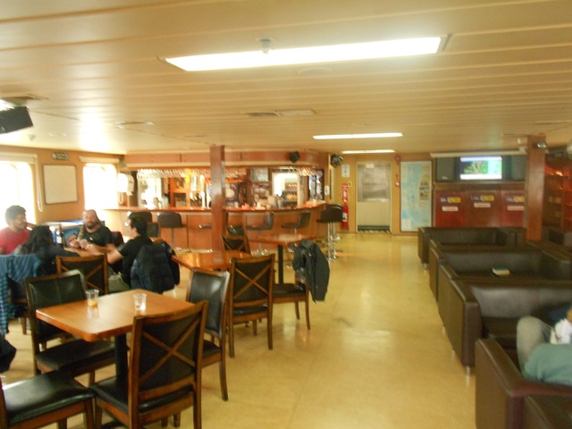
The ship contained three levels we passengers were allowed onto during the voyage. At the top was the bar, a fairly large area where we spent most of their time when not eating, sleeping or doing some of the other activities on board.

DSCN2233

Level two contained the more expensive cabins and the dining hall. This large room was used for, well, dining, but also for lectures, which they gave twice, once in spanish and once in english. These lectures were about Patagonia, birds, whales, our destination and the like. In the afternoons/evenings they showed movies or documentaries here also. While we were sailing, they showed: The March of the Penguins, Ice Age 4, James Bond – Skyfall, The Vow and several others.

wpid-dscn2238-2013-04-18-16-07.jpg

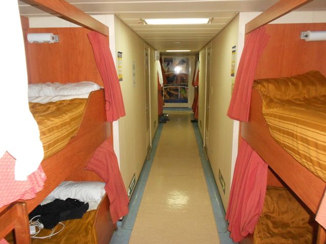
Lastly, on the lowest level were the main sleeping quarters. There were several different levels of cabins, from ones with windows and toilets to ones without. Also in the sleeping quarters was The Dorm, a figure eight corridor with a series of 22 bunks set into the walls. Each bunk had a curtain, a light, a power socket and at the end a locker. There were several bathrooms scattered around the corridor. This lowest level of accommodation was adequate, but the noise of people going past or having conversations  kept you awake unless you have a good set of ear plugs.

DSCN2236

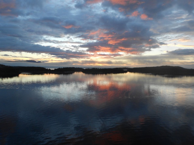
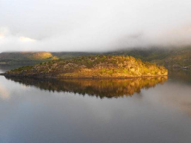
I boarded the ferry on Monday night and hung out in the bar with a friend before heading off to bed. The ferry left port at 8am on Day 2 and meandered its way along the fiords towards the southernmost part of the route, a place called the White Narrows, before it again heading north along a series of channels. The weather grew steadily worse as we went, but we did get a few pictures in the morning.

DSCN2204

While I was expecting landscapes similar to Antarctica because of our proximity to the South Patagonian Ice Field, the low cloud ensured we saw little of the ice field. The views were mainly of rocky islands with the occasional bird.

wpid-dscn2217-2013-04-18-16-07.jpg

There were apparent sightings of dolphins and a seal, but not while I was out looking for them. The White Narrow was the only place in the fiords the ship can pass through to head north without heading into the Pacific Ocean and while it was particularly narrow, it wasn’t white.

DSCN2219

For the rest of the day and night we worked our way through channels with the aim of coming out through the English Narrow into the Golfo de Penas. We were warned that the sea might get a little rough and many of us medicated with seasickness pills just in case. From the gulf we headed out into the Pacific Ocean to round Region Alsen del General Carlos Ibanez del Campo.

wpid-dscn2209-2013-04-18-16-07.jpg

The rain started before we headed through the English Narrow on Day 3 and continued for most of the rest of the journey. Strong winds hit us in the gulf as did the swell. While my group of companions and I held out fine, that evening the dining room was only half full and many people hovered in their rooms/bunks or threw up in the bathrooms. After my trip to Antarctica, I actually rather enjoyed the roughness of the sea, finding it fun fighting against the listing of the boat to get from one area to the next.

DSCN2227
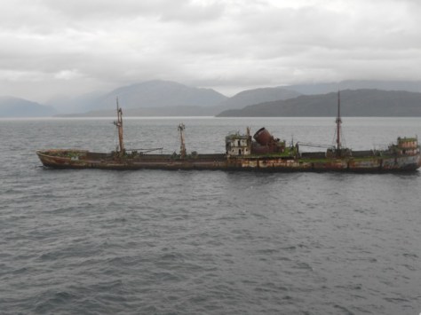
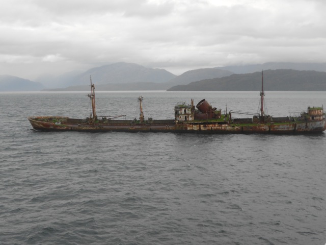
An old shipwreck sitting on a bank.

In the afternoon of Day 4, we crossed back into the fiords and reached Canal Moraldes.  Overnight we sailed north through Golfo Corcovado, passing Isla del Chiloe before eventually arriving at Puerto Montt in the early afternoon of Friday. We’d been due to arrive earlier that morning, but the winds in the Pacific caused us to run 7 hours late. While cruising slowly into Puerto Montt harbour we were escorted by a Southern Right Whale, a pair of dolphins and a seal. And yes, I saw them this time.

While the weather wasn’t the best for the trip and the views weren’t always great, the cruise itself was still most enjoyable. I made friends and hung with them in the bar, playing my board games (Carcasonne and Coloretto). They were very popular as they were different to the standards: the chess, checkers, dominos and the like that was available at the bar.

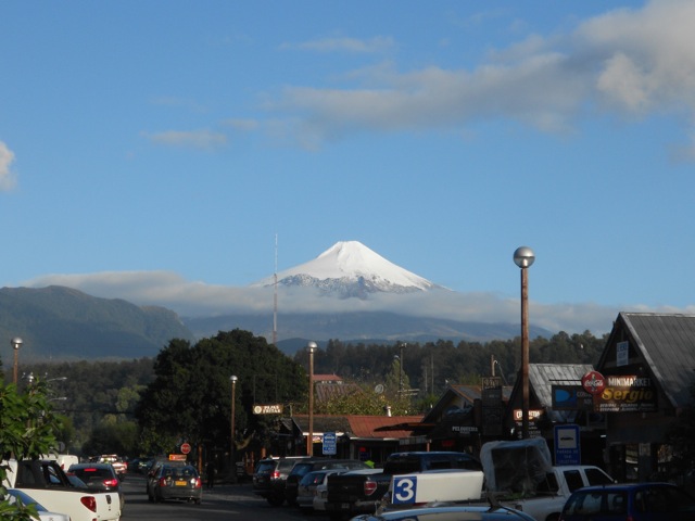
From here, I spent two nights in Puerto Montt planning my trip north and getting supplies ready for hiking in the Lakes Regions, a slightly warmer region of Northern Patagonia.

The Boat Wanderer

El Chaltén, Argentina – Impressions

El Chaltén is a small town at the northern end of Parque Nacional Los Glaciares in Argentina. It’s a town bred purely from the tourism generated by the National Park and Mt Fitz Roy.

DSCN2184

El Chaltén was quaint and had plenty of hostels, although many were aimed more towards the hotel end of the market than to backpackers. There were plentiful tour operators and adventure stores selling the big named adventure gear for both hiking, ice climbing and glacier expeditions. There was also a small cafe/bakery scene in the town which was great, as the hostels don’t provide breakfast.

I stayed at the Hostal Pioneros del Valle. This large and fairly cheap hostel had plenty of rooms, most set up with 6 beds. But as it was low season when I stayed I had the room to myself. Splendid!

DSCN2072

High season is December to the end of March and outside of these times more than half of El Chaltén’s businesses close down. The several restaurants in town are reasonably priced restaurants, including the local micro-brewery, which is good considering the town doesn’t have good facilities for buying your own food. While there are supermarcados, they aren’t very ‘super’.

The National Park had great day walks and several longer hikes – some very intense indeed. Being short on time, I only did a 3-day hikes. It doesn’t have an official name but I called it the Mt Fitz Roy Triangle. The other great advantage of the Parque Nacional is it’s cost. It’s free. Something different in a land of expensive national park entrance fees.

Here are some of the other walks:

  • Cascada Margarita
  • De las Vuetas River Canyon
  • Piedras Blancas Glacier
  • Punta Norte – Hito Limítrofe

Next, I head back through El Calafate to Puerto Natales in Chile to catch the Navimag Ferry

The Lone Trail Wanderer

Buenos Aires, Argentina – Impressions

After an exhausting 11-hour flight from Auckland to Santiago de Chile, wandering around the Aeropuerto Internacional, I quickly realised my 8-week spanish course hadn’t prepared me for being in a place where no-one speaks english. The airport wasn’t the most straightforward of places, but I eventually found my way to my connecting flight, not before walking up and down the airport at least a dozen times.  Luckily I had plenty of layover time.

As I flew out of the pencil thin country the sight of the many layers of the Andes blew my mind. Alas, my phone battery had died on the long flight so was unable to take photos.

Unlike the rather mountainous and brown Chile, Argentina is flat and plentifully green. Two hours after leaving Santiago de Chile I landed in Buenos Aires, a sprawling city of 13 million people. I booked my bus to the hostel and 90 minutes later I arrived. Being driven around Buenos Aires is an experience. There are lines on the road to help make things orderly but few drivers use them, they jam themselves in willy nilly. On several occasions we nearly clipped another vehicle, a regular occurrence based on the amount of dents many cars have.

I stayed in the America del Sur Hostel in the inner city suburb of San Telmo and found it an excellent hostel. The english speaking staff were always helpful, the beer fridge well stocked, and the wi-fi was good.

DSCN1456

It was hot and muggy in Buenos Aires, but since I’d been living in Brisbane I was used to it. I took my opportunity to wander the streets and see what was around. I’d originally planned a bicycle tour so didn’t take many photos, but due to flight changes didn’t end up taking the tour.

While touring Australia a couple of months earlier I’d been notified that my flights to Ushuaia had changed. Two days before the flight I was notified that it’d been changed again, a day earlier.  This cost me money to try to contact them, prepaid nights at the hostel and caused me to miss my bicycle tour. This wasn’t the first trouble I’ve had with Orbitz – a US travel company – and do not intend to use them again.

DSCN1455

The streets of Buenos Aires are narrow and many are paved. They must hold regular elephant races through the streets as many footpaths are smashed and have jagged concrete sticking up in many places. After a bit of a walk I found a statue, parliament house and the main central city open-air shopping mall.

DSCN1452

While there were plentiful police around, I stayed aware of the people around me and a kept my hands near my valuables. Buenos Aires has a dangerous reputation for petty crime with street thugs, pickpockets and muggings.  For my first Latin American experience I erred on the side of caution.

The open-air mall was very large, continuing for many blocks and crossing roads – mostly one way streets, where cars race by almost unannounced. There was also the ever-present call of ‘cambio, cambio’ – change, change – from black market foreign money exchangers.  I was warned not to use their services even though they can offer some excellent rates, but since they only accept US dollars and the Euro, I had nothing to change anyway.

DSCN1453

They have everything you could need in the central city, although the streets are dirty, with rubbish, dog faeces, people sitting around at random spots, old buildings, broken foot paths, broken buildings and the smokers – EVERYONE smokes. But this doesn’t make Buenos Aires a bad place, just mysterious, quaint and smoky.

Then, just as I started to get used to it, it was time to leave. My stay in Buenos was about settling into a foreign speaking country, dealing with the culture shock and getting a few things sorted for my ongoing trip.

Next, I headed to Ushuaia, in the province of Tierra del Fuego – Land of the Fire – the southernmost region of Patagonia.

The Lone Trail Wanderer

Naracoorte – South Australia

On the road from Kangaroo Island to the Grampians, I stopped at Naracoorte, a town famous for its world heritage listed fossil caves. Naracoorte has a system of 26 caves of various sizes and is one of the major – but not the only – caving systems in South Australia.

The day before I arrived, I had pre booked an adventure caving session. Luckily a couple had also booked, as there is a minimum number.

After a brief bit of training, we decided on a cave called the Blackberry Cave, because to has a lot of crawling around and tight spaces.

wpid-dscn0418-2012-11-24-18-01.jpg

The three of us and our guide climbed into rooms of amazing rock formations. While it’s a short cave and not for the claustrophobic, there’s enough room to crawl around although even with the knee pads, I still sustained some bruising.

wpid-dscn0431-2012-11-24-18-01.jpg

We got to the bottom of the Blackberry cave after a 45 minutes where we were told of a short tunnel that circled back into the chamber. It was tight and I went down first. I slid in head first as per instructions and prepared myself for the next part. I pushed through a tight gap, but my thighs caught and I couldn’t get through. Not prone to panic, I pulled back a little and tried from a slightly different angle. I was eventually able to shuffle through and up out the other gap.

wpid-dscn0435-2012-11-24-18-01.jpg

Caving can be sweaty work even though there is a sustained 17 degree temperature down there. We scrambled back to the surface. A lot of fun. I’m looking forward to my next one.

wpid-dscn0436-2012-11-24-18-01.jpg

The three of us were able to wander unassisted around a larger cave system known as the Wet Cave.

wpid-dscn0438-2012-11-24-18-01.jpg

There will be the first of several instances of spelunking I’ll be doing on this trip, with plans to do some in every state.

wpid-dscn0441-2012-11-24-18-01.jpg

The Cave Wanderer

Kangaroo Island – South Australia

Adelaide to Kangaroo Island to West K.I. Caravan Park

The road trip to Kangaroo Island was a mad 90 minute dash from Adelaide to Cape Jervis. Getting out of Adelaide was the hard part, it seemed like the city might not wish me to leave. A water main had stopped traffic on the Main South Road, and when I took an alternative, a car broke down right in front of me. Adelaide has a southern Expressway, but it’s one way only and time dependant as to which way. In the afternoons, you can only use to to get into the city, so I had to take the alternate route was fairly quick .

I raced towards the cape – the most southern point of mainland South Australia – passing through a town with a name I’m sure my brother would love: Myponga. I didn’t smell at all…

wpid-dscn0300-2012-11-19-19-17.jpg

As I raced towards the cape, I could see the ferry growing closer. I made it to the car park with 10 minutes to spare before we were loaded onto the ferry.

wpid-dscn0306-2012-11-19-19-17.jpg

The ferry was a 45 minute ride to Kangaroo Island, and because of a pair of stock trucks on board, it smelled like cows. It arrives at the eastern end of the island and I had to get to the other end where I was staying, some 140km away. Yup, it’s a pretty big island.

wpid-dscn0313-2012-11-19-19-17.jpg

I was warned to be careful when driving at night or in the morning, as wildlife like to hang out on the road. I got to the caravan park without running anything over, but saw far more roadkill than I would have liked to.

Flinders Chase and Ravine des Casoars Wilderness Protection Area

wpid-dscn0324-2012-11-19-19-17.jpg

Ravine des Casoars

The western end of the island is a National Park and has many different walks and things to see. I chose the Ravine des Casoars hike, one of the hardest on the island. The start of the walk is about 45km from the camping ground and a two-thirds of that is over a very dusty dirt road with many areas of corrugation. This was slow going and took me over an hour to get to the site. I did stop briefly to watch a couple of Goanna’s fighting…

wpid-dscn0326-2012-11-19-19-17.jpg

The walk itself is along the side of a ravine, then drops down into the ravine to walk out to the beach. At the beach, there is golden sand and interconnecting limestone caves.

The walk itself was not difficult, but crossed several different types of terrain, rocks, stony ground, dirt and sand. The trail cut through trees for much of its way…

wpid-dscn0330-2012-11-19-19-17.jpg

…until it headed down into the ravine and then followed a stream out almost to the sea. One of the hardest parts was walking along the sand bank while trying to avoid falling in the water. There were plentiful Goannas along the trail, some more than a foot long, and far too many flies.

wpid-dscn0339-2012-11-19-19-17.jpg

The azure blue of the sea was lovely against the golden sand. The rock formations along the side were amazing. Unfortunately, I didn’t know about the caves until I was there and hadn’t brought a torch with me – something I will remember to bring on every short hike from now on.

wpid-dscn0348-2012-11-19-19-17.jpg

The caves were amazing, and disappeared into the darkness, some of them formed tunnels that connected with some of the other caves. If I had a torch and I would have explored further.

Admiral’s Arch

At the the southern most tip of the National Park…
wpid-dscn0368-2012-11-19-19-17.jpg

‘’’is the Admiral’s Arch. A natural arch of rock…

wpid-dscn0378-2012-11-19-19-17.jpg

Near the arch were several New Zealand Fur Seals. If I was here a couple of weeks later, many more would have been here. They are all off out at sea mating, apparently.

wpid-dscn0375-2012-11-19-19-17.jpg

Remarkable Rocks

Not far from the Admiral’s Arch are the remarkable rocks.

wpid-dscn0389-2012-11-19-19-17.jpg

200 million years ago, a magma boil broke the surface and cooled. Over the millions of years, the rocks have been eroded leaving the unusual collection of massive rocks. The look like an artist created them. Remarkable, really.

wpid-dscn0390-2012-11-19-19-17.jpg

Seal Bay Conservation Park

Along the south coast of Kangaroo Island is Seal Bay Conservation Park.

Walking along a long boardwalk, you can get right down near the Australian Sea Lions that have come to the shore to sleep .

wpid-dscn0409-2012-11-19-19-17.jpg

There is also the skeleton of a hump backed whale along the boardwalk also.

wpid-dscn0406-2012-11-19-19-17.jpg

Tomorrow, I head back to the mainland to Naracoorte for some Adventure Caving.

The relaxed on an island Lone Trail Wanderer