All posts by Keyman

Cambridge, England – Impressions

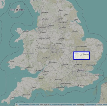
Less than 100km north of London in Cambridgeshire is the small city of Cambridge well known for its prestigious university. With the UK summer packing up after only 3 weeks of sunshine, I headed out of London for the weekend to explore this piece of England’s history.

cambridgemapengland-2021-06-22-17-22.jpg

Cambridge is very much a student city with 20% of its population attending one of the two collegiate universities in the city. Young people swarm like well educated flies all over the city, whether playing sport in the myriad of parks, flying past on scooters or bikes, hanging in groups around the central city, or later in the evening, in lines trying to get into bars.

img_7607-2021-06-22-17-22.jpeg

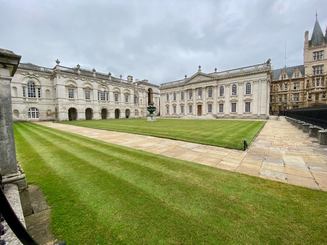
One of the first thing you notice about the city is the architecture, but it’s not just the grand gothic style of King’s college or the myriad of churches around the city. Cambridge has a modern style mixed in with the more classic ones.

cambridgearchitecture-2021-06-22-17-22.jpg

As my visit was only for the weekend, I spent much of Saturday exploring the various locations of the city with the intention of taking in some of the museums prior to my Sunday return train.

img_7595-2021-06-22-17-22.jpeg

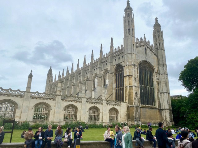
The collegiate University of Cambridge, founded in 1209, consists of 31 separate colleges. It’s the second oldest university in the English-speaking world, with Oxford University the oldest. Each of the colleges have multiple grand buildings spread through the central city. The building above is the King’s College Chapel.

img_7602-2021-06-22-17-22.jpeg

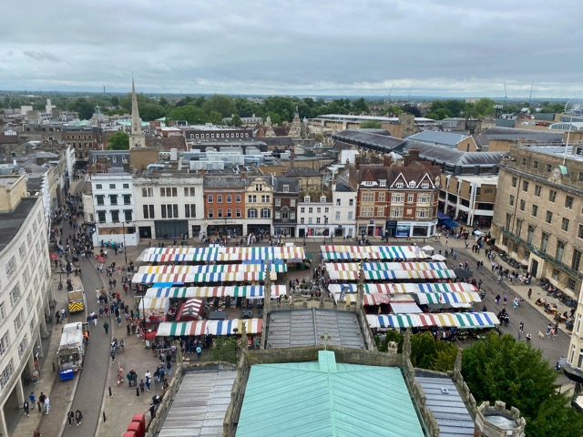
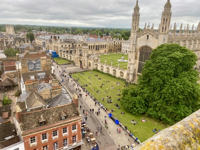
Across from the college is Great St Mary’s, a small 15th-century church with a climbable tower and a viewing platform offering panoramas of the city, including this view down onto Cambridge Market Square. The market had many different food stalls, most with lines of eager people waiting to sample their delights.

img_7631-2021-06-22-17-22.jpeg

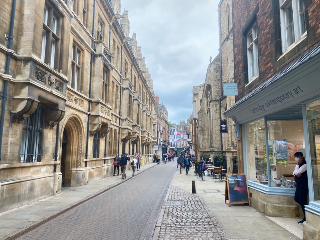
North of Great Saint Mary’s is Trinity Street, running alongside Trinity college, an architecturally pleasing span of road leading to the north of the central city, and St John’s college.

img_7641-2021-06-22-17-22.jpeg

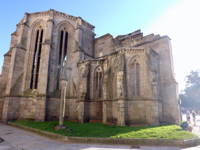
The street ends at the Round Church, a landmark church built in 1130 and only one of four remaining medieval round churches still operating in England.

img_7643-2021-06-22-17-22.jpeg

Not far from the Round Church is the River Cam, a place popular for punting tours. A punt is a flat bottom boat pushed through shallow slow moving rivers with a punt pole. The River Cam cuts its way along the west and north sides of the central city, most of it used for punting.

img_7574-2021-06-22-17-22.jpeg

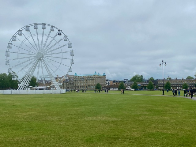
A walk along the river led to one of the many parks littering Cambridge central city, some with interesting names. This one is Parker’s Piece, while others are called Christ’s Pieces, Midsummer Green and Jesus Green.

img_7623-2021-06-22-17-22.jpeg

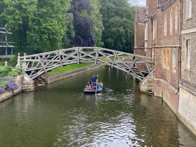
The river leads past various bridges, many unique in their build, such as this one, called the Mathematical Bridge. Its a footbridge crossing into Trinity College, built from straight beams in a mathematical precise shape.

img_7627-2021-06-22-17-22.jpeg

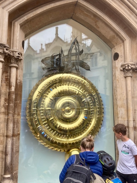
On my wanders through the city I discovered an odd clock in the wall near King’s College. It’s called the Corpus Clock and is also known as the Grasshopper Clock due to the mechanical grasshopper that walks along the top, ‘eating time’. The clock’s time is only correct every 5 minutes and is supposed to reflect life’s irregularity.

img_7588-2021-06-22-17-22.jpeg

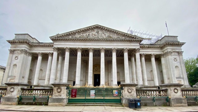
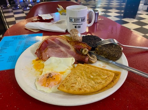
On the second day of my stay in Cambridge, the rain was supposed to come, so I intended to take in some of the free museums around the city, such as the Fitzwilliam Museum above. Unfortunately, due to COVID, to maintain social distancing there is limited space in each, and pre-booking is required. Unfortunately, they were all booked out, so after a relaxing morning, I found my way to a cafe serving a full English breakfast, before heading back to London.

img_7629-2021-06-22-17-22.jpeg

Overall Impressions
Cambridge is a wondrous city to wander around with eye catching architecture at every turn. It felt small wandering around the central city, but with plenty to see. It’s a shame many indoor attractions were booked out, but it will inspire me to book ahead on my next trip, to Oxford in a couple of weeks.

The World Wanderer.

Isle of Wight, England – Impressions

After lockdown eased and on the first British long weekend, I couldn’t help getting out of London. I’d put this trip off after booking it a year ago, and I’m now looking forward to exploring the island a little.

isleofwightmap-2021-06-1-20-28.jpg

The Isle of Wight is in the English Channel off England’s south coast, near Portsmouth, Southhampton and Bournemouth. The island is known for being Queen Victoria’s favourite summer holiday location and a hotbed of dinosaur fossils and a pivotal defence for the region against the Spanish Armada and in the Battle of Britain.

img_7563-2021-06-1-20-28.jpeg

My trip to the island was long, with an hour-long train ride across London, a 2-hour train to Portsmouth and a 25-minute catamaran ferry crossing to the township of Ryde.

img_7499-2021-06-1-20-28.jpeg

If I’d done a little more research, I’d have noted one of the world’s last commercial hovercraft services still operates from Portsmouth to Ryde and would have booked that instead of the ferry.

img_7500-2021-06-1-20-28.jpeg

With several hours to kill before my accommodation opened in Shanklin, on the south side of the island, I hung out in Ryde for lunch and had a wander around. After many weeks of rain in the UK, the sun decided to make up for it all in one go, marking the arrival of summer. I ordered takeaway fish and chips and sat in a small park overlooking the channel while I ate. Of course, fish and chips are a staple in London, but fresh cooked on the seaside is just better.

img_7503-2021-06-1-20-28.jpeg

Due to track upgrades, the cross-island train was closed, so after lunch and a climb through Ryde’s commercial streets, I made my way to the bus station for the trip to Shanklin. I arrived almost an hour later, but still too early for my accommodation. I stopped off at the local information centre/cafe, grabbed a map and a cider, then I began looking at things to do for the weekend. After checking into my accommodation, I explored the township, finding a path down to the beachfront.

img_7505-2021-06-1-20-28.jpeg

While Ryde is a typical British seaside township, Shanklin is a typical beachside township with many hotels and restaurants on the shoreline. The Pirate Cove and Jurassic Bay Adventure Park spanned several blocks, with plentiful ice cream stalls dotted about. At the end of the bay is the Shanklin Chine, a small tourist gorge with woodland paths leading up the cliff to come out near my accommodation.

img_7508-2021-06-1-20-28.jpeg

The Chine is nicely set up with well-manicured paths, a waterfall and a heritage centre with historical displays. Later that evening, coloured lights came on in the gorge, giving it an almost magical feel that photos don’t quite do justice. Then, after a beachfront dinner, I headed back to my accommodation.

img_7514-2021-06-1-20-28.jpeg

The following morning over my Full English Breakfast, I had to decide what to do for the day. While one of the main attractions on the island is The Needles, a series of chalk stacks in the bay, they’re 2 hours away by bus on the far end of the island. So, I decided on the less travel option, to the township of New Port near the island’s centre, to check out Carisbrook Castle, the Newport Minister, a museum of island history and a Roman villa.

img_7539-2021-06-1-20-28.jpeg

Newport is an hour by bus, and the castle on the hill outside of town, a further 20-minute walk. When I arrived, I discovered they weren’t accepting walk-in visitors, so I booked a ticket online. With 90 minutes until I was allowed in, I walked to a local supermarket to get some lunch, then back up the hill to wait for my entrance time.

img_7525-2021-06-1-20-28.jpeg

Carisbrook Castle was built in the 12th century atop a hillside where several roman forts had once stood. It is most notable for being the prison of King Charles I before his execution for treason and then 250 years later, the home of Princess Beatrice, Queen Victoria’s daughter.

img_7542-2021-06-1-20-28.jpeg

On a more personal note, the major sporting venue in Dunedin, New Zealand, was named after this very castle. The castle was in better repair than many I’d seen in the UK over the past few years. After I toured the castle and the high keep on the hill above it, I made my way back into town.

img_7547-2021-06-1-20-28.jpeg

I contemplated taking the bus to the Needles, but it drove by before I could get to the bus stop, so decision made, I headed back into Newport. When I got to the Minister, I found it was closed, at 2 in the afternoon on the Sunday of a long weekend. Disappointing.

img_7554-2021-06-1-20-28.jpeg

I headed to the Roman Villa and found that closed too, and was equally bemused to see the museum also closed. I’m not sure if this was due to the COVID lockdown or if the smaller town didn’t merit having these items open on a long weekend? So, I caught the bus back to the beach. But instead of stopping at Shanklin, I continued on to Sandown at the other end of the bay. With tourists enjoying the sun and beach, I walked around towards the white cliffs.

img_7556-2021-06-1-20-28.jpeg

When the path ran out, I walked back towards Shanklin, past the Sandown pier. The beachfront goes all the way to Shanklin, so I decided to walk the 3 miles back. A peaceful and enjoyable walk. In Shanklin, I stopped for dinner and a couple of ciders before heading back to my accommodation for the night.

img_7557-2021-06-1-20-28.jpeg

The next morning after breakfast, I caught the bus back to Ryde with the intention of walk to a nearby winery. But during the bus ride, I discovered the short tour I wanted to take was also on hold due to COVID. So, with nothing else to do, I went to the waterfront for lunch and awaited my ferry back to the mainland. Thankfully, I was able to take an earlier crossing to Portsmouth and its Emirates Spinnaker tower before my 2 and a half hour train ride home.

img_7566-2021-06-1-20-28.jpeg

Overall Impressions
The Isle of Wight was a lovely weekend away from London, but many things were closed due to the timing. This made travel times on the island long and meant I couldn’t see everything I’d have liked to. Disappointing, but perhaps I’ll return again in the future with a vehicle to make getting around a little easier.

The World Wanderer

Edinburgh, Scotland – Impressions

In the past 2 months, I’ve spent time in 6 different European countries, enjoying their cultures and hiking. But like the midges of Scotland, the more you scratch, the more the travel bug itches. So, under the again rising heel of COVID, I flew to Edinburgh for a long weekend to explore Scotland’s capital.

edinburgh-2020-10-3-19-51.jpg

While it rained for most my first day in the city, I still made the most of seeing what I could, starting with a most glorious Full Scottish Breakfast, including haggis. Then I was off to explore the rainswept streets looking for indoor activities.

img_7186-2020-10-3-19-51.jpeg

Architecture
Compared to many other cities in the UK, Edinburgh is perhaps the most majestic, with grand architecture across much of the city, and classic stone buildings which turn black in the rain.

9ccfd376-fa27-476c-b084-224009878eaa_1_105_c-2020-10-3-19-51.jpeg

Scott Monument
At the edge of the New Town, a gothic spire pokes up into the grey sky dedicated to the writer Sir Walter Scott. In the early 19th century, he wrote the famous poem The Lady of the Lake, along with the novels Waverley, Rob Roy, and Ivanhoe. He now sits beneath the spire in polished marble contemplating the rain.

83dbaee2-83fa-4a79-ae9c-0cbd18d39830_1_105_c-2020-10-3-19-51.jpeg

Carlton Hill
On the eastern end of the New City, the craggy, grass-covered Calton Hill protrudes from the cityscape. I climbed it on the rainy first day of my visit, but not all of the views were muted. The Dugald Stewart monument, dedicated to a Scottish philosopher, was built in 1831 and modelled after the Tower of the Winds in Athens. In the background is the Old Town with the gloomy Edinburgh Castle in the distance.

c472b803-1e7e-419b-bcb8-226b5918e89e_1_105_c-2020-10-3-19-51.jpeg

I climbed it again on my second day, with the sun out, for better views across the city to the Firth of Forth.

a863bbea-2f92-42ce-83ae-1ff4b0d31ed9_1_105_c-2020-10-3-19-51.jpeg

There are several monuments on the hill, including The National Monument of Scotland, left unfinished in 1829, a memorial to soldiers and sailors who perished in the Napoleonic Wars.

4e3f7e24-e83c-479f-b335-f7c2d2e956c4_1_105_c-2020-10-3-19-51.jpeg

Nelson’s Tower monument, to commemorate Vice-Admiral Horatio Nelson’s victory over the French and Spanish fleets at Trafalgar in 1805.

a3085c37-9f8e-409c-975a-dc9381206072_1_105_c-2020-10-3-19-51.jpeg

At the top of the hill is an observatory. I investigated the domed building to discover a philosophical experiment where, over time, they are collecting 3D renditions of people to populate a new world. I came for the views and ended up getting digitised to live among thousands of other digital souls in the exhibit.

img_7314-2020-10-3-19-51.jpeg

Camera Obscura and The World of Illusions
On the Royal mile near the Edinburgh Castle, Camera Obscura and the World of Illusions is the oldest purpose-built attraction in Edinburgh. Over five floors, plus the roof, there are more than 100 interactive illusion based exhibits, although the Camera Obscura is closed due to COVID.

f29e33c2-b20e-4474-b5dd-62f40a0763f0_1_105_c-2020-10-3-19-51.jpeg

But, the rooftop still gives one of the better views of Edinburgh, even across the wet city.

80e5f775-3808-44cd-b934-a94292d9c160_1_105_c-2020-10-3-19-51.jpeg

The kinds of things you see in the World of Illusions are quite varied, with mirrors featuring in many ways, in 3D representations and other twisted mirror illusions. Other tricks include a collection of multi-view pictures like the one below, shadow photographic stunts, on the fly software morphing, and various electrical tricks. While it is popular with kids, it’s also fun for adults on a rainy day.

62e300cc-1b58-438e-b996-570861fd8d46_1_105_c-2020-10-3-19-51.jpeg

The Scotch Whiskey Experience
After visiting the Guinness brewery in Dublin, I couldn’t not do the Scotch Whiskey Experience while in Edinburgh. The tour begins in a moving barrel gliding through the process of making Scotch Whiskey. It then teaches us about the five different regions of Scotch distillation and each of their characteristics.

c2e5a8c8-97e6-491b-a14d-91ebeadc6124_1_105_c-2020-10-3-19-51.jpeg

We were then walked through a room with a collection of 3000 unopened bottles, no two the same, one bottle having been bought for US$3000 in the 1970s.

8ea1952f-14d4-4bc8-a684-8aeb147f2dfd_1_105_c-2020-10-3-19-51.jpeg

The final part of the experience is, of course, the tasting. The standard silver tour comes with a single tasting, but the gold, which I bought, includes five so I could try all of the different regional Scotches.

Edinburgh Castle
With the sun coming out on my second day in Edinburgh, I explored the grand castle on the hill.

img_7245-2020-10-3-19-51.jpeg

Edinburgh Castle is the most besieged place in Scotland and one of the most attacked places in the world. In its 1100-year history, it’s been under siege some 26 times.

img_7279-2020-10-3-19-51.jpeg

But, after the Lang Siege in the 16th century, it had to be rebuilt as it had been largely destroyed by artillery bombardment. There’s a vast amount of history in the walls, with several small museums, and, of course, great views in all directions.

81db403e-fb65-442d-99c6-dbd92c57c182_1_105_c-2020-10-3-19-51.jpeg

Leith and the Firth of Forth
With the sun continuing to hold on the 2nd day of my visit, I took a thirty-minute walk along a street lined with polished stone building out to the port district of Leith beside the Firth of Forth.

img_7300-2020-10-3-19-51.jpeg

Leith has a definite British suburban feel, similar to where I live in Wembley, but once on the waterfront, it steps it up a notch, with expensive-looking high-rises and hotels. I walked along the coast a little way to Newhaven, before cutting back into central Edinburgh. All up about a 6-mile walk, well needed after the big breakfasts and all the Scotch.

The Edinburgh Dungeon
The dungeon is one of several underground ‘shows’ designed to showcase some of Edinburgh’s history but includes visitor interactions, 4D style effects, frights and laughs.

img_7319-2020-10-3-19-51.jpeg

Visitors head down through small underground corridors in dim light to several well set up small rooms. We witnessed a witch trial, some haunted rooms where we learned of some gruesome deaths, witnessed ghosts looking for vengeance and hung out in the sewer sanctuary of cannibals. The acting and storytelling were excellent, although the COVID masks did impede speech for some of the quieter speakers.

img_7318-2020-10-3-19-51.jpeg

Overall Impressions
Edinburgh is a beautiful city architecturally with plenty to do inside during the rain, typical for Scotland, but also many outdoor activities for those lucky enough to see the sun.

Until next time,

The World Wanderer.

Camino Portugués de Costa – Spain – Days 10, 11 & 12

In late August 2020, with the world still under the heel of the COVID-19 pandemic, I walked the Portuguese Coastal Camino de Santiago over 12 days.

Back to Days 6, 7, 8 & 9

caminoportuguesdays10-12-2020-09-17-19-49.jpg

Day 10 – Pontevedra to Caldas De Reis – Spain – 21.3km
Today the trail was quite straightforward following the road out of Pontevedra. As usual, I was on the lookout for breakfast and found a cafe popular with peregrinos. But there I ran into a dutch lady I’d met in the Porto Albergue the night before I’d begun my Camino. It was refreshing to hear English being spoken fluently again and not the occasional forced second or third language.

dscf0189-2020-09-17-19-49.jpeg

While the Camino Portugués has some views, much of the experience is cultural or spiritual, and it’s known for the camaraderie between pilgrims. However, due to COVID, few English speakers were tempted to this side of Europe. This and Americans not already resident in the EU weren’t allowed at all. This has led my Camino to be a contemplative and somewhat solitary experience.

img_7153-2020-09-17-19-49.jpeg

Once out of Pontevedra it was a quick march through country roads before several kilometres of slow climbing on a dirt path before heading back into villages. The trail led me past fields of grapevines, and even taking me under some.

dscf0192-2020-09-17-19-49.jpeg

There were few views today on the way to Caldas de Reis, and tonight I have a room to myself in a hostel. Caldas de Reis is a town known for its hot springs. In many places along the trail, there are washing pools with running water for pilgrims to clean their clothes or rest weary feet in the cool water. In Caldas de Reis, however, I found a pool filled from a hot spring. It was heaven and great for the leg muscles. I saw others using it too, some stripping down to their underwear and getting right in.

img_7155-2020-09-17-19-49.jpeg

Day 11 – Caldas De Reis to Padrón – Spain – 18.9km

After eating the breakfast left for me by my hosts, I headed out across Caldas del Reis on quiet streets as it’s Domingo – Sunday.

dscf0195-2020-09-17-19-49.jpeg

I found a coffee and took it with me as I headed out of town, tossing the cup in the last bin I saw. For the next few kilometres, the path climbed 150m, although it wasn’t intense, and in the cool wind, the climbing kept me warm. Today, the first part of the trail is mainly dirt and runs through forest, so not a lot to see.

dscf0197-2020-09-17-19-49.jpeg

I passed a rest stop hankering for a coffee, but it was so full of waiting pilgrims I decided to push on. The path weaved across a highway before running beside a motorway until Valga where it began to descend through villages with fields of grapevines, corn and other crops.

dscf0200-2020-09-17-19-49.jpeg

Still hankering for a coffee, I stopped at a cafe in San Miguel de Valga. While I was there, a Dutch guy arrived, and we got talking. After having an early lunch, we left the cafe and chatted for the last few kilometres before arriving in the outskirts of Padrón, barely remembering the walk. There was a large Sunday market going on in town and masses of people everywhere. With the current COVID threat in Spain, this made me nervous, so and I suggested we take a less direct route through town. At the end of the market areas, we went out separate ways, and I located my hostel before heading out to explore.

img_7160-2020-09-17-19-49.jpeg

Padrón is a classic little town with a central old town like many places across Europe. In my exploration, I ran into the Dutch guy once more, and we sat for a beer and some food before he headed off to his hostel outside of town.

img_7164-2020-09-17-19-49.jpeg

Day 12 – Padrón to Santiago de Compostela – Spain – 25.6km

On the final day on this latest adventure, I headed out from the hostel and along the dark streets of Padrón. Today, I’d read, would be one of the less interesting days, as the trail begins the slow climb into Santiago de Compostela and right from the beginning the urban sprawl began. After five kilometres, I arrived at A Escravitude, where I found this Igrexa.

img_7166-2020-09-17-19-49.jpeg

For the next 15 or so kilometres, I walked through leafy suburbs on thin roads making my way uphill towards the centre of the city.

dscf0204-2020-09-17-19-49.jpeg

From here there are few views, and those are mainly of low hills and tree-covered suburbs.

dscf0205-2020-09-17-19-49.jpeg

When I entered the main built-up area of the city, the path led me along the main drag. With more stone buildings around, the heat rose, and I found a vending station to buy a drink. The road then led me up to the Central Park, which in turn led me into Cidade Vella – Old Town in Galician. Cidade Vella in Santiago is rather large and is a spiderweb of walkways with many shops, restaurants and cafes. I found my way to the official ending point of the walk and emerged in the grand square to perhaps 20 groups of pilgrims spread out in front of the Cathedral de Santiago de Compostela.

img_7167-2020-09-17-19-49.jpeg

I found a shady spot at the back of the square and sat down for a rest, watching pilgrims in the square languish about taking photos as more groups arrived. After my break, I located the pilgrim office, filled out the relevant online form and collected my official certificates of completion. I then located my hostel and checked in before returning to find lunch. Later, I got a late afternoon photo of the cathedral.

img_7172-2020-09-17-19-49.jpeg

I then ran into a Spanish girl who I’d seen walking and discovered she spoke English. I sat down for some beers with her and another Spanish guy. Later that evening, we gathered a group of Spanish people, some who could speak English, and went for dinner and more beers. Much fun was had.

I spent the next day wandering around the old town of Santiago and eating local food. While it’s served many places, I located a suitable place to try to Pulpo – Octopus – which I rather enjoyed.

img_7176-2020-09-17-19-49.jpeg

Final Impressions of Camino Portugués de Costa

I have completed two hikes this year, and this would have been my first had COVID not caused it be moved after the Tour du Mont Blanc. This was a long-distance, low altitude, cultural experience with some views, while the TMB was a challenging, high peak climbing, massive mountain hike with amazing views. While I very much enjoyed the cultural experience of the Camino, it would have been better to do it first as the TMB took away some of its grandeur. That and with many English speakers avoiding the region meant fewer friendships were made and more of a lonely experience.

img_7086-2020-09-17-19-49.jpeg

But, in the spirit of the Camino, it was still an enjoyable cultural experience. It opened my eyes to the beauty of northern Portugal, and allowed me to experience Spain. The food in both countries was amazing and the people friendly and understanding of my low level of Spanish. I have studied the language to a beginner level and it was enough to survive, but it has pushed me to reach the next level before I head to Spain for my next Camino, the Camino Frances in a year.

The Lone Trail Wanderer

Camino Portugués de Costa – Spain Days 6, 7, 8 & 9

In late August 2020, with the world still under the heel of the COVID-19 pandemic, I walked the Portuguese Coastal Camino de Santiago over 12 days.

Back to Days 3, 4 & 5

caminoportuguesdays6-9-2020-09-17-19-49.jpg

Day 6 – Villadesuso to Baiona – Spain – 14.6km

I left the Albergue looking for coffee and breakfast as I walked through the Villadesuso with nice views of the coast. I then ran into a Portuguese couple I’ve seen for the past two days and walked with them to Mougás, 2km away, where I found a cafe. After eating, I continued on along the side of the road, occasionally dipping down to the seaside before climbing back again. I met a carver outside his shop who was very friendly and offered me a stamp for my credential. We chatted for a bit, and I bought a Camino shell from him for my pack.

dscf0134-2020-09-17-19-49.jpeg

I continued along the coast, and when I reached the village of As Mariñas, with its small lighthouse, the trail climbed a hill. It was again nice to climb something, but it wasn’t difficult.

dscf0135-2020-09-17-19-49.jpeg

On the other side, the trail led down into the edge of a built-up area with views out onto the bay.

img_7113-2020-09-17-19-49.jpeg

Further along and found the Portuguese couple at a pilgrim rest area. We walked on together for 3km before arriving into Baiona, a large tourist town on the beach. They continued on while I located my Albergue and showered before heading into town for lunch and a beer.

img_7117-2020-09-17-19-49.jpeg

Afterward, I explored the tight streets, investigated the front of the castle on the peninsula, including the beaches on each side. I then went for a walk to the end of the bay, where I climbed a hill to the statue of the Virgin Mary – Virgen de la Roca.

img_7126-2020-09-17-19-49.jpeg

The height also gave me great views across the bay.

img_7129-2020-09-17-19-49.jpeg

Day 7 – Baiona to Vigo – Spain – 30km

As much of today will be a slow process of walking into increasingly built-up urban sprawl, I was prepared for a boring day. I walked out of my hostel, and along the road to a local cafe for coffee, before finding a panaderia for some fresh baked goods. I then walked down the coastline road to the end of the shops before following it inland and up the hill towards A Ramallosa. After several kilometres through back streets, I came to Nigrán and, on the far side of a roundabout, found the statue of a pilgrim.

img_7133-2020-09-17-19-49.jpeg

After Nigrán, the path began to climb but remained in the sprawl. As before, the height offered some views, this time across the bay of Ría de Vigo to two large islands, Illa de San Martiño and Illa de Monteagudo.

img_7135-2020-09-17-19-49.jpeg

The path continued along, giving more views of the islands, but grew more steadily built up. I rounded the edge of the bay and entered the main built-up areas after Coruxo and began to see tall buildings in the distance. For much of the rest of the day, I walked through busy central city streets and roads. There is a fair amount to explore in Vigo, but it was hot, and I was footsore from all the pavement, so didn’t hang around. I then discovered my hostel was in the old town, a fair way away from the trail, so put my head down and marched on. I eventually arrived to find my hostel in what appeared to be a run-down area with plenty of graffiti and empty buildings. But after checking into the hostel and showering, I went for a wander. I turned a corner and came out on an open area filled with cafes, and on the far side, it opened into a large commercial area.

img_7136-2020-09-17-19-49.jpeg

I hung around the area, chilling out at a restaurant, enjoying people watching and seeing the culture of the area as I drank beer. When darkness fell, other bars and restaurants opened, including a pizza place. I have enjoyed local food but had a hankering I just had to sate.

Day 8 – Vigo to Redondela – Spain – 17.5km

After breakfast in a local cafe, I headed a couple of kilometres up the hill back to the main path and continued on. The heat started early today, but it’s only a short day, so I wasn’t in a hurry. Over the next couple of kilometres, the path climbed up to about 150m and stayed there for much of the rest of the day, allowing me to enjoy the views along the way.

dscf0161-2020-09-17-19-49.jpeg

The trail and the views continued as I walked through the higher urban areas.

dscf0163-2020-09-17-19-49.jpeg

The pavement joined Senda de Agua – water track – a dirt path through the forest, past a small waterfall, and this painted rock.

dscf0165-2020-09-17-19-49.jpeg

After several hundred meters, the track came out into the suburbs again, giving a view of Ponte de Rande before disappearing back into the forest.

dscf0171-2020-09-17-19-49.jpeg

I began descending and emerged at another urban area near a church – the Igrexa parroquial de Santo André de Cedeira – with another view across the harbour.

img_7138-2020-09-17-19-49.jpeg

From there, it was all downhill into Redondela, which is the official end to the Portuguese Coastal Camino. But this isn’t the end of my walk, the Central Route from Porto also stops here, and this is the trail I’ll follow the rest of the way to Santiago. The heat is apparent, and so is the fact the two trails have connected, as there are many more pilgrims on the streets and in cafes.

img_7149-2020-09-17-19-49.jpeg

After finding my Albergue, I showered and headed back into town, where I found the Celtic Lead Irish Bar and enjoyed lunch and a couple of beers. I then met up with a Portuguese couple I’d crossed paths with since Esposende, and we wandered the hot streets before finding our way back to the Celtic Luad for more beer.

img_7147-2020-09-17-19-49.jpeg

Day 9 – Redondela to Pontevedra – Spain – 19.7km

As I prepared for today’s walk, I watched several groups of pilgrims go past in the dark outside the hostel. I’m up early today as it’s going to be another hot one. And now I’m on the Central Route, the number of pilgrims has noticeably increased. I head out and follow the cobbled town roads on my way out of town. After passing several peregrinos, I stopped on the main road for breakfast and a coffee. I then raced on along the road for a short time before coming to a street vendor selling fruit and drinks, but more importantly, offering stamps. I stopped for another coffee before heading off again, passing a group of five Spanish girls on the side of a busy highway. The path then led through a small village with a pair of Albergues and yet more pilgrims. The hard road turned to a dirt road surrounded by trees and began climbing slowly as it made its way around the end of the Ria de Vigo bay.

dscf0174-2020-09-17-19-49.jpeg

The trail headed back into a built-up area before heading down a steep downhill to the main road. At the end of the bay, I came into the village of Arcade and crossed the river that fed into the bay.

dscf0175-2020-09-17-19-49.jpeg

On the bridge, I ran into the Portuguese couple. I walked with them for the rest of the day following the road through several villages as we made our way to Pontevedra, the capital city of Galicia. We stayed in the same Albergue and after showering we walked around the city to see its sights, two grand churches…

dscf0179-2020-09-17-19-49.jpeg

…a bridge, a convent, and the ruins of an ancient church.

dscf0187-2020-09-17-19-49.jpeg

Next, Days 10, 11 & 12, where I finish my pilgrimage in Santiago de Compostela.

The Lone Trail Wanderer

Camino Portugués de Costa – Portugal & Spain – Days 3, 4 & 5

In late August 2020, with the world still under the heel of the COVID-19 pandemic, I walked the Portuguese Coastal Camino de Santiago over 12 days.

Back to Days 0, 1 & 2

caminoportuguesdays3-5-2020-09-17-19-49.jpg

Day 3 – Esposende to Viana Do Castelo – Portugal – 28.5km

With yet another hot day coming, I headed out from the hostel and quickly found a coffee and breakfast. I then headed to the beach and followed the wooden boardwalk along the seaside. It was just early enough for holidaymakers to begin making their way down to the beach. But, it would also be the last beach I’d see for the rest of the day as the path cut inland through suburban roads to the town of Marinhas.

I then followed backroads through several villages, with only the occasional view of the ocean. I came through the township of Belinho and crossed the main road, heading between two buildings with interesting stonework. The houses here are all very different, many are covered in patterned tiles or stonework. I’m told the tiling is very common in Northern Portugal.

img_7096-2020-09-17-19-49.jpeg

I continued on for another couple of kilometres making my way to the Rio Neiva after which there is a stiff climb, the first on this hike. However, a recent flood had wiped out the bridge, so a detour took me well down towards the coast to another one. On the other side, the path led me back up the hill where I passed the Italian walkers I’d met the day before. I then climbed a hill near Castelo do Neiva, a church with a fair view along the coast and ocean.

img_7102-2020-09-17-19-49.jpeg

The trail then led me up over a small peak – 155m – then through a eucalyptus forest where a sign pointed me to a house and a stamp. On the other side of the hill, I came to a large old monastery, Mosterio de São Romão de Neiva, where I stopped at a pilgrim’s stop for some water. There are many Pilgrim stops along the trail, with stone seats, water fonts, and sometimes pools to wash clothes or dip hot feet into.

img_7151-2020-09-17-19-49.jpeg

Then, after the township of Chafé, I climbed a steep set of roads and came down with a view of Viana do Castelo across the Rio Lima, including the church on the hill, Santuário de Santá Luzia.

dscf0069-2020-09-17-19-49.jpeg

And a closer look…

dscf0075-2020-09-17-19-49.jpeg

I crossed Ponte Eiffel, a bridge built by Gustave Eiffel, I’m sure I don’t need to mention any of his other projects. The bridge is near a kilometre long with a thin walkway on either side. My accommodation was right on the other side, so I got a good shot of it from the other side, including the bay.

img_7104-2020-09-17-19-49.jpeg

At the hostel, I had originally booked a bed in a 20-bed room, but due to COVID, they had closed it, upgrading me for free to a room with four beds, which I had all to myself.

Day 4 – Viana Do Castelo to Caminha – Portugal – 28.4km

After breakfast at the hostel, I headed out through town following the high route, which passed below the Santuário. After a couple of kilometres on the same kind of road with only the occasional view, I decided to detour down to the beachfront, where I passed the remnants of several windmills. With the wind off the ocean, it was cooler than on the higher path.

dscf0082-2020-09-17-19-49.jpeg

Then after an hour, I climbed the hill at Carreço back to the higher road for another impending climb. As the Camino has few ascents, I treasured any climbs as they usually come with views.

img_7107-2020-09-17-19-49.jpeg

On the other side of the hill, I walked into the town of Âncora and then to the beach – Praia de Âncora. With the heat continuing to rise, I again enjoyed the cool ocean breeze.

dscf0102-2020-09-17-19-49.jpeg

I followed the trail along the beach for a couple of kilometres into Moledo where I had my first sight of Spain and Monte de Santa Tregá.

img_7109-2020-09-17-19-49.jpeg

I followed the road around and into town where I spied the word “stamp” in yellow on the ground along with an arrow pointing to a balcony. On it, a strange man was smiling at me and offered me a stamp which he assured me was free. We chatted for a bit before I again headed on. The remaining 5km into Caminha was a flat and straight road. That evening I ate a cheese and sausage platter for dinner – why not – before going for some beers with an Italian guy I’d run into a couple of times. But, like many others I’d met in Portugal, he wasn’t crossing into Spain due to the much higher COVID rate.

Day 5 – Caminha to Villadesuso – Spain – 20.2km

As it’s Monday, the ferry to Spain doesn’t run, but the guy at the Albergue told me I could catch a water taxi from 8 AM. I went down to the harbour at 9 AM, but no-one was there.

dscf0108-2020-09-17-19-49.jpeg

I went for a coffee, and when I came back, other pilgrims were also waiting – two Spanish guys and a Swiss girl. Eventually, the four of us were able to catch a water taxi across the harbour.

dscf0113-2020-09-17-19-49.jpeg

We arrived in the sleepy town of Camposancos, where the path took us up the hill. It didn’t climb too far before heading us down again to A Guarda, a seaside town with plenty of charm. Now I’m in Spain, the clocks have gone forward an hour, and it’s already lunchtime. But by the time I got to the end of the town, I’d neglected to get anything so decided to get something at the next village. I left A Guarda passing a beach with some topless ladies, something I discovered is common in Spain.

dscf0120-2020-09-17-19-49.jpeg

There is no longer wooden boardwalks, the trail is now along a rocky path. Also, Spain has a more strict mask-wearing policy, so I have to be more vigilant. The trail led me along beside the sea for sometime before climbing up to the road, then a couple of kilometres further on returned me back to the beach.

dscf0121-2020-09-17-19-49.jpeg

After 6km I came to Portecelo, but there were no shops in the village, so I kept walking. After another 6km I arrived in Oia where there were 2 restaurants, but as it was only mid-afternoon, I grabbed a bag of potato chips and a coke. 4km further on was my stop for the night, Villadesuso and I got settled into the Albergue.

dscf0128-2020-09-17-19-49.jpeg

Compared to Portugal, the Spanish speak less English, so it was time to put my Spanish lessons to the test. I found a restaurant in a hotel with special peregrinos rates: €15 for 4 courses, including a drink. However, the waitress spoke no English, but I managed to get by with my limited vocabulary and even managed a short conversation. Then it was back to the hostel and bed.

Next, Days 6, 7, 8 & 9, where I drink at an Irish bar Spanish style and reach the capital of Galicia.

The Lone Trail Wanderer

Camino Portugués de Costa – Portugal – Days 0, 1 & 2

In late August 2020, with the world still under the heel of the COVID-19 pandemic, I flew to Portugal to begin the Portuguese Camino de Santiago. The route I chose begins in the city of Porto and runs along the coast to the border of Spain, where it makes its way slowly inland to Santiago de Compostela.

europemarked2-2020-08-24-17-40.jpg

The total length of the route is 280km, which I plan to complete over 12 days. Unlike the Tour du Mont Blanc, which I completed recently, Camino Portugués do Costa is fairly flat, so it will be more of a daily hike for distance than massive climbs. And, before water, my pack will be between 9kg and 10kg. Except for the first day, the trail is well marked, either with the symbol of the shell with an arrow or just a yellow arrow.

img_7071-2020-08-24-17-40.jpeg

Day 0 – Porto Arrival
I arrived in Porto the day before the hike and was collected by a regional workmate. From the airport, he took me on a tour of the city, showing me several sights, including this temple in Gaia north of the city. The haze is actually fog.

img_6994-2020-08-24-17-40.jpeg

We then stopped at a top seafood restaurant for some local delicacies, cod patties, squid, and sardines asadas. Amazing. My workmate then dropped me off at my Albergue. After booking in, I went for a walk and found this church – Igreja do Carmo – with its tiled facade.

img_7016-2020-08-24-17-40.jpeg

That evening, I hung out with a slowly growing group of employees, new pilgrims, and other recent arrivals. We drank beer and waited as an asada – BBQ – was prepared with salted beef. Then, a dozen of us crowded around a table and enjoyed a great dinner. Afterwards, a fire was stoked, and we sat around drinking more beer while an American guy played guitar.

img_7029-2020-08-24-17-40.jpeg

Overall a great experience, and this even before I’d started walking.

caminoportuguesdays1-2-2020-08-24-17-40.jpg

Day 1 – Porto to Vila do Conde – Portugal – 33.2km

As I went to bed later than expected, I woke late – 7 AM – and went down to pack. I’m usually more prepared at night, so it takes less time in the morning, but last night was fun. By 8, I was ready to head out. As I’m walking the coastal track – Senda Litoral – along the river to the beach and along the beachfront to Vila do Conde, my official start point is the Cathedral. I walked downhill to the Cathedral, adding an extra 2.7km to my route, stopping on the way for breakfast and a coffee. The below Monument to Bishop Pedro Pitões is at the front of the 12th-century religious site.

img_7011-2020-08-24-17-40.jpeg

I then found my way down to the river and followed the road around to and past the Ponte da Arrábida bridge watching some old fashion streetcars run back and forth along the tracks.

dscf0008-2020-08-24-17-40.jpeg

After 6.3km, I arrived at Foz do Douro, where the river meets the sea, and followed the boardwalk along the waterfront in front of houses and the Parque da Cidade. Next to the port, I spied the first beach. On the other side of the port, I passed the industrial part of the city, another beach, and a massive refinery. Then, after walking 20km, I finally left the confines of Porto city at Boa Nova Lighthouse and stopped for lunch at a local restaurant.

dscf0023-2020-08-24-17-40.jpeg

For the rest of the day, I walked along wooden boardwalks above the sand, slowly making my way north. From time to time, I passed small quaint seaside villages in classic Northern Portuguese style, the outer walls of the houses covered with tiles.

img_7059-2020-08-24-17-40.jpeg

At one point, a fog rolled in blocking views out to sea and further along the beach. There’s a cold current running along this region of Portugal, and on a hot day, the fog rolls up the beach. It’s odd, as I associate fog with cold days, but the sunbathers don’t seem to mind, although there’s not much swimming going on.

img_7063-2020-08-24-17-40.jpeg

I eventually headed inland and crossed a bridge into Vila do Conde, where I quickly found the hostel. After 37.5km, I was footsore and ready for a shower. A few buildings down I relaxed with a large beer before going for a brief walk around town. It didn’t take me long to realise walking more after today’s long walk was just silly, so I headed back to rest and prepare tomorrow.

img_7070-2020-08-24-17-40.jpeg

Day 2 – Vila do Conde to Esposende – Portugal – 24.4km

Well rested, I headed out in the morning, following a side road to a cafe where I stopped for breakfast and a coffee. I then followed a road towards the ocean, crossed at a tiled mural began along the beachfront.

img_7077-2020-08-24-17-40.jpeg

Much of the coastline in front of Vila do Conde is a beach, but when the town ends, so does the sand.

dscf0046-2020-08-24-17-40.jpeg

The rocky coastline continued for several kilometres before the trail took me inland. I followed a series of back roads through farmed fields and long white greenhouses with only the occasional view of the sea. Without the constant breeze from the Atlantic Ocean, the heat became more apparent. For the second day, it was clear blue skies and sunshine, weather that would last for the duration of my time on the Iberian Peninsula. The road continued on through the township of Apúlia, where I discovered a break room for pilgrims. It was simply a small room with a pair of vending machines, some seats, and the all-important stamp. To officially complete the hike, I need to get 2 stamps a day in my credential – also known as the pilgrim passport, so any opportunity to get stamps is welcomed.

img_7082-2020-08-24-17-40.jpeg

And in one of the vending machines, I was surprised to see beer, but I bought snacks and coke instead. While I was there, a large group of Italian pilgrims arrived. They seemed suddenly interested when they discovered there was a stamp and, ignoring social distancing, crowded inside. I chatted for a bit with some English speakers before heading off. As the pilgrimage was initially a religious experience, the trail wends its way past numerous churches every day.

dscf0049-2020-08-24-17-40.jpeg

The trail then led me through a forest on a dirt road before coming to the small township of Fão where I crossed Rio Cávado. On the other side, I followed a side road into Esposende, where I found my hostel wasn’t open for another 2 hours. I hung around in town, had lunch, and enjoyed the weather down near the river. For dinner, I tried something I’d been told about called Francesinha Especial.

img_7091-2020-08-24-17-40.jpeg

This feast is a triple-decker sandwich made with a meat paddy, steak, ham, beef sausage, and chorizo, lavished with melted cheese and topped with a fried egg. The entire thing is smothered in a special sauce and served with fries.

Next, Days 3, 4 & 5, where I see a church on a hill and cross into Spain.

The Lone Trail Wanderer

Tour du Mont Blanc – Switzerland/France – Days 9 & 10

In the Coronavirus infested summer of 2020, I walked the 10-day Tour du Mont Blanc. Here describes days 9 & 10.
Back to days 7 & 8.

Day 9 – La Peuty to Tré la Champ – Switzerland to France – 12km

tmbstage9-2020-08-12-20-21.jpg

After the storm overnight, the morning was fresh but everything outside was wet. This means I’ll be carrying at least an extra kilogram or more of rainwater as I won’t be able to dry the tent. After breakfast, and with a heavy feeling pack, I set out from the campground and following the sign, began the climb up the hill. My legs feel fine, even after the hard downhill yesterday. The trail soon cut up into the forest with steep switchbacks and the occasional view back to La Peuty.

dscf9987-2020-08-12-20-21.jpeg

After more than 20 switchbacks, I emerged from the forest to see Chalet du Col de Balme above me marking the border with France and the return of my phone coverage. I slogged on up the hill towards the 2200m height that would be the ceiling for today’s climbs. I came over the crest to the chalet and the brilliant views. Switzerland has plenty of views, but it’s not until you see the massif that you remember what you’ve been missing.

dscf9990-2020-08-12-20-21.jpeg

At the chalet, I took the opportunity to drop the pack and ordered a crepe and a soft drink. The only way to dry things after a stormy night is to hang it from my pack. So, I took out my still sopping tent and slung part of it over my pack before setting out again.

dscf9991-2020-08-12-20-21.jpeg

In the sun, I walked down the hill on grassy switchbacks to Col des Posettes then climbed again the 200m of elevation to Aiguillette des Posettes.

img_6959-2020-08-12-20-21.jpeg

The second peak was made of layered ridges of rock and jagged outcrops, a different kind of rock to that seen anywhere else on this trip. The wind picked up, and I climbed carefully, not wanting the breeze to catch my tent and drag me off. When I reached the top I found a large flat grassy area and 360º views. I dropped my pack and took some photos.

dscf9996-2020-08-12-20-21.jpeg

I then unpacked my tent and lay it out in the sun to fully dry. I also took the opportunity to get out of my boots. When everything was dry, I packed and began my descent.

dscf0001-2020-08-12-20-21.jpeg

I followed the trail to the end of the flat area before the climb down grew steeper with several switchbacks and wooden stairs. I stopped at a large rock for a view down into the valley and a small hamlet under a glacier.

dscf0002-2020-08-12-20-21.jpeg

The rest of the descent was in the forest. An hour later, I emerged then a short walk to Tré le Champ and the campground. The 2 Dutch couples were there, along with the Dutch guy and Dutch girl, although we had separate sittings for dinner, so didn’t hang out. After dinner, the rain continued and I dove into my tent to sleep.

Day 10 – Tré le Champ to Chamonix – France – 12km

tmbstage10a-2020-08-12-20-21.jpg

The forecast for today was not good and when I awoke the clouds were down to near ground level.

img_6964-2020-08-12-20-21.jpeg

Climbing in the mountains is not advised in the rain, or even a deep cloud cover such as this. I decided to have breakfast and wait to see if any changes were coming. But when more rain came, I decided not to risk the mountain and instead walk the 12km low route direct to my hostel in Chamonix. The route I mapped had very minimal climbing, indeed, a 350m descent over the course of the walk. When the rain stopped, I headed out, following a dirt trail beside a stream.

img_6967-2020-08-12-20-21.jpeg

I followed it for a couple of kilometres until it came to the township of Argentiere where I stopped for a morning snack. I pushed on at a march alongside the river with cyclists and day walkers enjoying the walk before the rain.

dscf0007-2020-08-12-20-21.jpeg

After about 9km I walked alongside a golf course, crossing through it at one point to a Les Praz de Chamonix. But with 2km to go, it began to pour. I found a tree and stood under it waiting for the rain to pass, but it just kept on falling. After 30 minutes, I set out again and thirty minutes later, dry inside my waterproof jacket, I arrived at the hostel. I showered and set out my tent to dry in the dining room before heading down into town for a drink and some lunch. Later I would have dinner and drinks with many of the people I’d met over the last few days, The British couple, the 2 American couples, the 2 Dutch couples, the Dutch guy and the Dutch girl. Even the Polish girl from the 2nd day of the hike made an appearance. It was a fitting end to a great hike which turned out to be more than just a walk in some rather tall mountains.

cxnr3475-2020-08-12-20-21.jpeg

Overall Impression on the Tour du Mont Blanc
While I’ve had harder days on other hikes, overall, the TMB was the most difficult hike I’ve completed. It started out as just one of my hikes for the year and became something I’ll always remember. The landscape and the massif itself is up there in the most beautiful regions on earth I’ve experienced. As I walked this hike during Coronavirus infested 2020 there were far fewer people than normal, but it still turned out for the best. Maybe better because of less crowds.

dscf9920-2020-08-12-20-21.jpeg

And, while I began alone as always, I didn’t finish that way. Part of the hike was the people I met and shared this experience with, thanks to those people for being part of this experience. And, as always, this hike wasn’t just an external experience, but an internal one. During the long meditative days, great insights into my life were had. I hope to see them come to fruition in the future.

img_6958-2020-08-12-20-21.jpeg

Would I suggest others do this walk? Definitely, but it will take courage, good health and a certain level of fitness.

Next, my adventures take me to another part of Europe I’ve yet to visit – Portugal and Spain, for a partial Camino de Santiago.

Until then,
The Lone Trail Wanderer.

Tour du Mont Blanc – Switzerland – Days 7 & 8

In the Coronavirus infested summer of 2020, I walked the 10-day Tour du Mont Blanc. Here describes days 7 & 8.
Back to days 5 & 6.

Day 7 – La Fouly to Champex – Switzerland – 14km

tmbstage7-2020-08-12-20-21.jpg

After a conversation with yet another Dutch couple at the campground, I discovered the last part of today’s leg will be a bit of a slog. The wife walked it alone last year, and so they are planning to skip the last half of the day by catching the bus from Issert. I certainly wasn’t going to take the bus, but I took note. I walked out of the campground and headed along an open field towards the woods where I would follow an easy slowly descending trail. It was still warm, even early in the day, so I was glad for the shade for the first few kilometres.

img_6930-2020-08-12-20-21.jpeg

While the views from the Swiss portion are not as good as the other sides, the mountains are still beautiful.

dscf9966-2020-08-12-20-21.jpeg

After a brief climb, the trail hugged the lower slopes of the mountain on a thin path, and one section even had a chain to hold onto, just in case. The trail then headed through the forest, and it felt as if I was walking along a long thin tree-lined avenue – a 1.5km long section of very straight trail with only two bends.

img_6936-2020-08-12-20-21.jpeg

When I came out, the trail headed onto grassy fields past a Swiss hamlet. It then worked its way towards the village of Praz-de-Fort where I went looking for a cafe and a cold drink. I found the Dutch guy at one also having a drink, so I stopped for a chat.

dscf9965-2020-08-12-20-21.jpeg

I headed off a few minutes after him and came around onto another road with a quaint village ahead where I stopped to retrieve my lunch from my pack. I was preparing to leave when the Dutch girl came along after me. We walked together for a bit, but she stopped in the next village for a break, while I pushed on to Issert.

dscf9968-2020-08-12-20-21.jpeg

A hundred metres after the village the trail cut up a hill made more difficult by the summer heat. Issert sits at 1040m above sea level and my target Champex is at 1500m, not a huge climb compared to other days. The trail went into the forest for shade, but forests have their own humidity, so it is warm either way. As I had been warned, the climb was a slog, with little along the way to see. Someone, however, had carved various animals into tree stumps to give us something to see. There’s a viewpoint along the route, and well worth the wait.

dscf9970-2020-08-12-20-21.jpeg

And another 20m further on there is a water fountain, something common along the trail, with potable water and another view.

dscf9969-2020-08-12-20-21.jpeg

Four kilometres after Issert, I came out of the forest and climbed around the streets of Champex until I found myself above Lac de Champex. I walked to and along it for a kilometre until I reached my campground.

dscf9971-2020-08-12-20-21.jpeg

After pitching my tent, I headed back to the lake, where I ran into the Dutch guy. We found the English couple and the young Dutch couple from the night before, along with (yet) another Dutch couple, the girls from each Dutch couple being sisters. Yes, the Dutch invaded my TMB, but no complaints from me. A large portion of walkers are French who speak various levels of English. The few Italians along the way were similar. The Dutch I met, to a person, were fluent in English, which made it easy to connect with them. Later, after eating with the Dutch guy, everyone got together to play cards, along with an American couple — all good company.

Day 8 – Champex to La Peuty – Switzerland – 14.5km

tmbstage8a-2020-08-12-20-21.jpg

The official route today via Alp Bovine is supposed to be a forest walk with some spectacular views. However, there’s a variant, more challenging and with a climb above 2600m, the highest point of my TMB, with unmatched views. Leaving the campground, I followed a path away from the road then turned sharply and followed an irrigation channel. The trail climbed into the forest-covered valley for 1.5km until it came out at the chalets of Relain d’Arpette where I ran into the British couple from the past two evenings. I walked with them for a short time as we slowly climbed through wildflower meadows. They were faster walkers that I, so I wished them well and set my own pace into the grand view ahead.

dscf9974-2020-08-12-20-21.jpeg

After 2km, the trail grew flatter, and I followed the line of mountains up the valley. I eventually saw the point I would be climbing to, the lowest point of the mountainscape to the right of the photo’s centre.

dscf9975-2020-08-12-20-21.jpeg

The trail turned steeper and rockier, and I clicked back into the pace I had perfected over the past 8 days. With my legs used to the effort, the steep climb seemed fairly easy, although the sweat continued to drip from me. Looking back the way I’d come…

dscf9976-2020-08-12-20-21.jpeg

The climb is quite varied, and after a time the trail cut through a massive boulder field. Bouldering is fun, trying to balance while skipping from one to the next. Some find it hard, but it didn’t take me long to work my way past it. There were some snow patches on the mountain and one right on the trail. On the far side a very steep zigzagging path to the crossing point – Fenêtre d’Arpette.

dscf9979-2020-08-12-20-21.jpeg

This last part of the climb was the most difficult, and I stopped after each short zigzag to catch my breath. But still, it didn’t take me long to make it to the top and cast my eye back.

dscf9980-2020-08-12-20-21.jpeg

And of course, the sight you wait for while climbing… the other side. At 2665m, I sat to eat lunch and enjoy the view.

dscf9981-2020-08-12-20-21.jpeg

The greatest problem with climbing something tall is climbing back down again. The trail was quite thin, and after my break, I headed down, slowly. While my legs seemed used to climbing up, they still hadn’t gotten used to the down part. I descended beside the Glacier du Trient, the slick rock below it having once been covered by the glacier. As I continued down, my knees starting letting me know how much fun they were having. And, again annoying to see trail runners bounding down these slopes like they’re running down a short hill.

dscf9982-2020-08-12-20-21.jpeg

The trail hugged the edge of the mountain for a time on a thin trail before zig-zagging down the centre. I continued down for an hour before reaching an old hut where some people had stopped. The person before me was trying the water fountain, but it was only running warm, so I pushed on. Thankfully I found a glacial stream and drank my fill of the sweet cool water. I continued my descent for some time before the trail cut into the forest where I got a good view back up the mountain to the glacier.

dscf9983-2020-08-12-20-21.jpeg

Another hour and I came out at a cafe where several trails met and ran into the American couple from last night. As I’d just run out of my water, I bought a couple of soft drinks and sat with them for a chat. Then with dark clouds looming I headed off. The trail was now flat and had been purposely cut around the side of the mountain as a tourist walk. After 1.5km, I came to a downslope and to the annoyance of my legs, followed it down a zigzag path. Halfway down, I heard thunder and it began to rain lightly. I made it to the campground at La Peuty, not too wet, and ran into some of the others. In the gentle rain, I put up my tent with their help. After a shower, I booked dinner and ended up with the whole group again – British couple, 2 Dutch couples, the Dutch guy and the Dutch girl sitting around the table in a large teepee, eating burgers and drinking whiskey.

Tomorrow I head back into France where I will finish this epic trek. Tour du Mont Blanc – Switzerland/France – Days 9 & 10.

The Lone Trail Wanderer

Tour du Mont Blanc – Italy/Switzerland – Days 5 & 6

In the Coronavirus infested summer of 2020, I walked the 10-day Tour du Mont Blanc. Here describes days 5 & 6.
Back to days 3 & 4.

Day 5 – Courmayeur to Rifugio Bonatti – Italy – 11km

tmbstage5-2020-08-12-20-21.jpg

After a good night’s sleep and a massive breakfast at my Airbnb, I head down into the town for last-minute supplies. I stopped to take a photo of where I’d climbed down from yesterday.

img_6899-2020-08-12-20-21.jpeg

From Courmayeur, the trail follows a steadily climbing road for about 3km before cutting into the forest. Thankfully, my Airbnb at 1250m elevation was halfway along this road, cutting a bit of climbing off my day. At the end of the day, I pushed into the forest and up a fairly steep set of zig-zagging paths. With little to see but trees, I found my zone and got on with the climbing. I eventually came out of the trees at 1850m to great views across Courmayeur.

img_6907-2020-08-12-20-21.jpeg

A further 100m climb and I stopped briefly at Refugio Giorgio Bertone for a cold drink then climbed the hill above where I stopped for lunch. After eating, I had the difficult decision of whether to take the official route or the higher, harder, variant. After being told by my host’s son last night that the walk into Switzerland would be a hard one, I decided to follow everyone else along the easier route. The trail skirted around the side of the valley at about 2000m and stayed that way for about 5km. Always in its stunning beauty, across the valley, the wall of the massif.

dscf9946-2020-08-12-20-21.jpeg

The trail pushed into the forest and rounded into a gully where Torrente d’Arminaz, a wide and fast-flowing stream ran down the mountainside with a bridge crossing it. As it had been another hot day in the mountains, I found a great spot, got my feet out of my boots and into the icy water. No doubt the sound of my pleasure reverberated along the valley. With no hurry to push on the last couple of kilometres to my rifugio, I hung out at the spot for some time. As I did, other walkers came by, and they too took the opportunity to cool off in the water. Of course, it wouldn’t be right without one of my Dutch companions, this time the Dutch guy, who also got his feet into the water. After a while, we dried off, booted up and headed out.

dscf9947-2020-08-12-20-21.jpeg

The last couple of kilometres were an easy walk, and we came past another Dutch trio, a couple and their son, who I chatted to as we came to final 50m climb up to the Rifugio. It was still early afternoon, and the Rifugio didn’t open until 4pm, so as a group we hung out around the tables chatting in the heat. Because of Coronavirus, the rifugio was only accepting prebookings, so the Dutch guy continued on to find a wild camping spot. After a shower, I hung out with the Dutch family. We drank beer and ate Italian sausage while talking about the trek and admiring the view.

dscf9948-2020-08-12-20-21.jpeg

The father, about my age, had walked this route a couple of times. He had also climbed many of the peaks along the massif. I hung with them during dinner, which was full vegetarian, and then a couple more beers before retiring to bed early in preparation for the coming day.

Day 6 – Rifugio Bonatti to La Fouly – Italy to Switzerland – 17km

tmbstage6-2020-08-12-20-21.jpg

As yesterday was not as hard a day as I’d read, today is supposed to make up for it, with an intense descent, a hard ascent and another long descent. After breakfast, I bid farewell to the Dutch family, another group I wouldn’t see again and headed out around the back of the Refugio. Over the next 3km, there would be some minor climbs and descents, but the massive wall of the massif across the valley stopped me from caring, the beauty and immensity of it.

img_6911-2020-08-12-20-21.jpeg

I arrived at a farmhouse and saw that the trail cut down the mountain on switchbacks, although nothing too steep or difficult.

dscf9950-2020-08-12-20-21.jpeg

I followed the trail, descending 250m to Chalet Val Ferret, where I stopped for a cold drink. The weather again was warm, but storms were on the forecast later in the day. I followed the river for a short time until I came to the beginning of the first climb, which was crowded with cows. Looking for an alternative route, I followed the road around for a bit before climbing the steep grassy slope, a 350m climb before it flattened out. A short sharp climb took me to Rifugio Elena, which is closed this season. I stopped for a break and a bite to eat before the big climb to come. The view opposite…

img_6913-2020-08-12-20-21.jpeg

The first signs of dark clouds could be seen as I climbed the at times steep path zigzagging its way up the mountain for another 475m of elevation.

img_6917-2020-08-12-20-21.jpeg

Since I’ve been climbing for five days, while the sweat is still pouring off me, my legs have grown used to the effort, and again I don’t seem to notice the hardship as much. As I topped Col Val Ferret and the border of Switzerland, I stopped for lunch and to enjoy the view, putting on a jacket in the cooler breeze.

img_6915-2020-08-12-20-21.jpeg

After eating, and at the first signs of rain, I headed down the other side into Switzerland. The trail flowed gently down into the valley, and I stopped as a Marmot ran across the trail.

img_6918-2020-08-12-20-21.jpeg

Not long after, the rain came briefly before the heat again rose. I followed the trail down before it zig-zagged a couple of times and came out at a farm, Alpage de la Puele, where I stopped for a cold beer. I continued on down on a green hill that felt reminiscent of everything I’ve ever seen of Switzerland, heading steadily down to a river. I crossed and following a road around into a forest.

img_6920-2020-08-12-20-21.jpeg

After passing a quaint Swiss village, I cut down to the river again, where I found many piles of stones. I followed the river for some time, then after a short steep climb, I was deposited in La Fouly, a classic looking Swiss village. After pitching my tent at the campground, I headed into town for a beer and dinner.

img_6924-2020-08-12-20-21.jpeg

I sat alone enjoying a drink on a table next a young British couple and a younger Dutch couple. I was reading my guide book when who should appear but the Dutch girl, who’d already met the two couples. We joined them and began talking about food when an American couple appeared, shortly followed by my friend, the Dutch guy. A good evening was had with the larger group, ending with 4 of us in another bar playing cards. Unfortunately, just as we were leaving, the sky opened in full storm, leaving two of us ran back to the campground.

Next, two more days in Switzerland. Tour du Mont Blanc – Switzerland – Days 7 & 8.

The Lone Trail Wanderer