Iguazú Falls, Argentina and Brazil – Impressions

On the border of Argentina and Brazil are the mighty Iguazú Falls.  One of the seven new wonders of the world, the falls connect a national park in each country. The falls are among the seven largest waterfalls in the world, a third larger than Niagara Falls.

DSCN2572

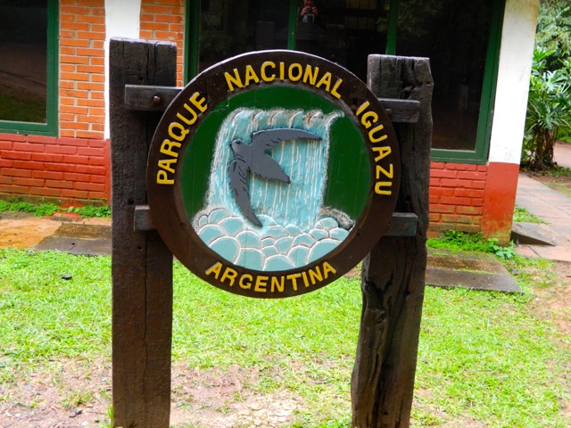
From the Argentinian township of Puerto Iguazú it’s easy to see both sides of the falls.  The Argentinian side has many wide cascades of water at several levels while the Brazilian side has the Devil’s Throat, a U-shaped section of the falls. Here are details of both with prices correct as at June 2013:

Argentina – Cataratas del Iguazú

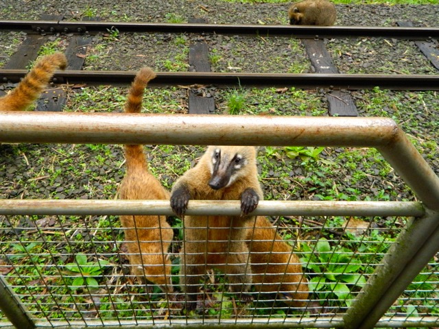
The trip from Puerto Iguazú by bus takes about 15 minutes. The Argentinian side is the more expensive of the two parks at $170 pesos (about US$34), but it has the larger tourist area. There are several different walks in the park and a boat tour that takes you up close to the cascades. The boat tour – the Gran Adventura – is fairly expensive at $350 pesos (US$70) but I booked it anyway. Near the booking area I came across some South American Coatí scavenging for food.

DSCN2571

It was raining on the day of my visit, so I bought a cheap rain poncho. After booking the Gran Adventura, I had an hour to kill so went for a walk around the park along a trail creatively named, ‘The Lower Trail’. Because of the rain and an excess of water going over the falls The Upper Trail was closed, which was a shame as it leads across a series of bridges to a platform above the Devil’s Throat.

The lower trail leads down the bank, past many smaller waterfalls to several lookouts with different views of the flatter side of the falls. At one point, the trail gets very close to the cascades where the spray is thick in the air.  Thankfully for the poncho I stayed mainly dry.

DSCN2598

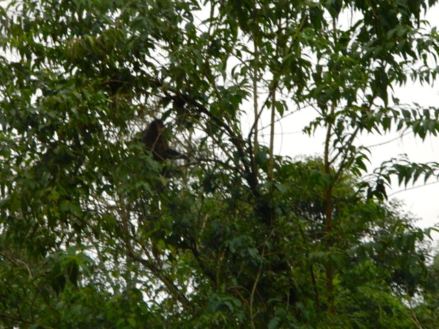
The Gran Adventura begins with a 30 minute safari through the rainforest where a guide introduces several different native trees and I got to see my first ever monkeys in the wild.

DSCN2602

Then we were strapped into the boat and shot off at full force along the river.

DSCN2610

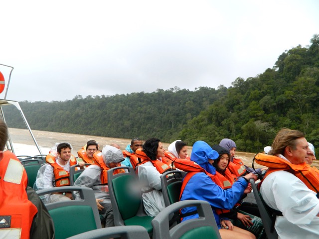
With so much of the thick dirty brown water coming over the falls, the water eddies like crazy and even the big jet boat was thrown around. With the amount of spray coming off the falls it was difficult to get close to the churning water coming down the Devil’s Throat…

DSCN2609

…so we spent more time getting close to and drenched by the cascades section.

DSCN2617

Then it was a crazy ride back along with the river, back into the safari trucks and out of the park.

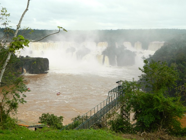
Brazil – Cataratas do Iguaçu

The trip to the brazilian side of the falls takes about 30 minutes, including a short stop at customs. Because it’s considered a tour, no fees or visas are required.

Brazil’s park is larger overall but with a smaller tourist area. It’s cheaper at $41 Reals ($US21). To get to the viewing platforms, you need to take an internal bus which can drop you off along the way depending on what tour you want to do. They also have  boat tours similar to the Argentinian side.

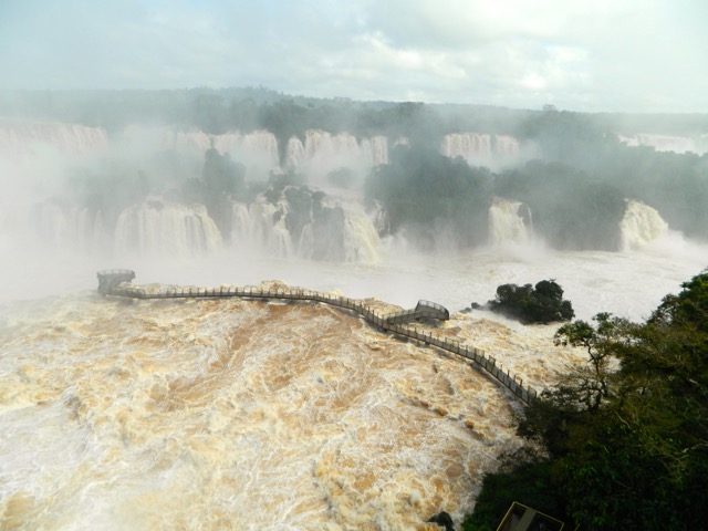
The park’s main path is slightly shorter than the Argentinian side but has better views, beginning with a view across the river to the cascades section of the falls…

DSCN2634

As you get closer to the Devil’s Throat, the trail zigzags up the wall to a viewing platform right at its side, which provides awesome views of the upper river pouring right down the Devil’s Throat.

DSCN2656

While there was a section also closed because of the height of the water, the views were still amazing.

DSCN2677

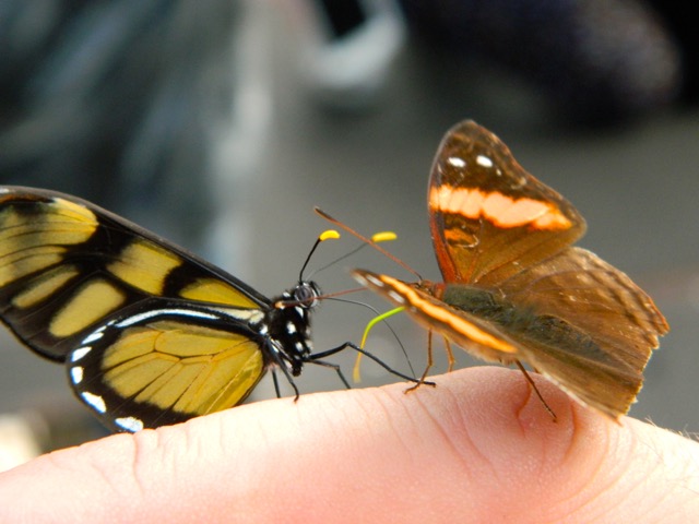
With no rain today there were plentiful moths and butterflies about. They will land on everything at a moments notice.  If they weren’t so colourful, they’d be considered pests.

DSCN2687

Overall, the falls are a definite must see. While you can be happy seeing just one side, it’s not hard to see both and well worth the money spent.

Next I’m off to see the wonders of Brazil and Rio De Janeiro.

The Lone Trail Wanderer

Buenos Aires, Argentina – Take 2

After several months travelling around the southern portion of South America I returned to my starting point of Buenos Aires. On my initial visit, I’d only spent 3 days there and hadn’t seen a lot of the city. On my return visit, I stayed 10 days to hang out with a group of locals I’d arranged to meet and to see some of the sights of the city, like the main courthouse.

DSCN2558

On my second visit I staying in the central suburb of Palermo at a hostel chain called Hostel Suites Palermo, which had an above average but nothing to rave about. Palermo is described as an up and coming suburb, but with homeless people living at the end of the block perhaps ‘slowly up and eventually coming’ is closer to the mark.

Buenos Aires has 3 million people and is quite spread out. Because of its size and with the lack of national parks in the province, walking around the city was where most of my exercise came from. One afternoon, I made plans to catch up with a new friend and walked an hour along one of the main streets lined with shops. When I finally got to the meeting point, the shops continued off into the distance.

DSCN2559

The next day, I walked in the opposite direction along the same street.  An hour later I arrived in the city centre and again shops had covered the entire distance and stretched on into the distance.  On my walk I stopped in at El Ateneo Grand Splendid, the bookstore to end all bookstores, an old theatre that had been converted into a book store. It’s the most famous bookstore in Argentina but has very few books in english.

wpid-dscn2555-2013-06-29-09-34.jpg

Near the centre of town is a large group of parks and on the next sunny day I wandered around a pond full of geese and sat reading on a bench as skaters and cyclists went by.

DSCN2523

On the next day it was forecast to rain, so together with a girl I’d met at the hostel, we checked out some of the more cultural features of the city centre, several monuments which we called ‘boob monuments’, as they all contained carvings of topless women.  Then when it began to rain, we looked around several museums and galleries in the area.

DSCN2520

With Uruguay on the far side of aptly named Rio Uruguay, I caught a ferry across to Colonia on the next sunny day to tick that country off my travel list.

Overall, Buenos Aires felt different to my previous visit. But during that earlier I’d been suffering culture shock. The ever-present doggie doo was still a major problem in Buenos Aires. I did see a handful of people pick up after their mutt only to find the bags of doggie doo left in the middle of the footpath. Progress is slow…

Next I headed to my final Argentinian destination, Puerto Iguazú and the country’s other major attraction, Iguazú Falls.

The Lone Trail Wanderer

Colonia, Uruguay – Impressions

Uruguay’s full name is ‘The Oriental Republic of Uruguay’, an english translated perversion of the name which actually means ‘The republic east of the Uruguay (river)’.

From Buenos Aires the ferry takes just over an hour to get to the small town of Colonia del Sacramento. It’s a must visit if you’re in Argentina’s capital for a few days. Although the trip can be a little expensive, about US$75 return, half of that for border taxes.

ferry-ride-buenos-aires-colonia

After a mad dash across Buenos Aires in a taxi, I made the ferry with about 30 minutes to spare and once through customs and onboard the catamaran, I promptly went for a nap for the hour and ten minutes it took to cross.

Compared to the madly bustling metropolis that is Buenos Aires, Colonia is small, quaint and tranquil. Much of the 500-year-old original town is still there with its original cobblestone roads and buildings.

wpid-dscn2528-2013-06-21-19-04.jpg

As part of the ferry booking there was a walking tour around the original township, nestled at the end of the peninsula. We walked to what was left of the wall that had separated the town during the War of Independence. The wall is now only about 30 metres long with a single gate and drawbridge, the rest having been removed. As a welcome there was a white-faced mime standing on a boulder just on the inside of the gate.

wpid-dscn2524-2013-06-21-19-04.jpg

Many of the old buildings have survived through the years and are protected by the government. Some of the buildings weren’t so lucky and have had new buildings built within their old structures…

DSCN2530

Other buildings have been refurbished and converted to other uses, in this case a restaurant…

DSCN2541

After the tour, I went to find something to eat and found a restaurant where a singer could be heard inside. Outside, there were three old cars that had been converted to other uses… this one into a two-seater table for the restaurant. The other behind has a garden growing in it.

DSCN2536

The restaurant was lovely as was the entertainment and they gave the prices for the meal in US dollars, Argentinian pesos and Uruguayan pesos, but it was expensive unless you’re actually paying in US dollars.

After lunch, I walked around the township enjoying the quiet. I stopped at an ATM in hope of getting some US dollars but it had run out.  Many people come to Uruguay from Argentina to get US dollars to sell on the black market, sometimes for twice its value. I was unlucky, they’d run out by the time I’d got there. Later I headed to the bay to watch the sunset. Just to the left of the island, the buildings of downtown Buenos Aires can just be made out.

DSCN2553

The trip back across the bay was uneventful and at approximately 10pm local time, I arrived back in Buenos Aires.

This was my only trip into Uruguay. After a couple of more days in Buenos Aires, I traveled north by bus to my final destination in Argentina, Puerto Iguazú – one of the 4 largest waterfalls in the world and home of the Devil’s Throat, Iguazú Falls.

The Lone Country Hopping Trail Wanderer

Parque Nacional Quebrada del Condorito

About 2 hours by bus south-west of Córdoba is the small Condor Gorge National Park. There is no formal transport to the National Park, you simply book a ticket to the nearby town and ensure the driver drops you off on the way.

wpid-dscn2495-2013-06-20-17-24.jpg

Córdoba province is at the northern ‘dry’ end of Argentina. Most of the upper regions are desertlike pampas, not sandy like the Sahara desert, but arid dry plains much like the Australian Outback just not as red.

After my two hour bus ride, I walked beyond the national park sign and along a dirt road between two private properties until it finally opened out into rocky rolling hills. After 10 minutes I arrived at the registration building and signed the book to say I was in the park.

There’s only one main natural attraction in the small national park, the gorge. It’s about 2 hours walk (according to the admin staff) to the southern lookout. You can continue down to the river and up the other side to the northern lookout, but that’s about it.

So, I set out from the the administration building and headed up the road a little further until the sign sent me onto a rocky trail heading up a gradual hill.

wpid-dscn2498-2013-06-20-17-24.jpg

I was told there are markers every 15 minutes on the way towards the southern lookout, but it only took me 10 minutes to reach each one, so I guess the markers are for the family groups and slower walkers.

wpid-dscn2503-2013-06-20-17-24.jpg

About 30 minutes in I reached the top of a cliff and looked down across the hazy pampas to the lake and the small villages scattered below. Then, as I began walking again, a condor swept up and floated on the air currents not 2 metres above.

wpid-dscn2501-2013-06-20-17-24.jpg

10 minutes later and I came to a sign warning me about Pumas and snakes. This actually gave me the sense that I was walking in Australia again with its dangerous wildlife. It’s like living on the edge!

Half an hour later I arrived at a split in the trail, to the left it headed to the southern lookout, to the right down to the river and up the other side. I took the left track and climbed down the side of the cliff a little to where the lookout was. I stopped there for lunch looking down on the gorge below and the small river running through it.

wpid-dscn2507-2013-06-20-17-24.jpg

The walk so far hadn’t been terribly hard, although it was rather hot in the sun with no trees for shelter. After lunch, I headed back to where the trail split and took the other route, following it until it began heading fairly steeply down into the gorge. It’s about a 500 metre climb down to the river, but it didn’t take me long and eventually I came out to the bridge and crossed to the other side.

wpid-dscn2517-2013-06-20-17-24.jpg

With the hard part to go, I paused under the bridge for a few minutes before starting back up the hill. It took me a fair amount longer to get back up the side of the gorge because of the constant climbing, but after a couple of rests along the way I did eventually make it and headed back across the rolling hills to the administration. Just as I left the admin building, I saw a bus go by on the road in the distance and knowing that they only go past every hour, I slowed my pace. After waiting almost another hour and unsuccessfully flagging down 3 other buses, one did stop for me and I was whisked back off to Córdoba.

Overall, it was nice to get back out on the trail after a couple of weeks wining and dining in Mendoza. It was great walking on a hot trail again like I used to in Australia and definitely different to the last few months hiking around the cold south.

With my next stop being Buenos Aires, and with the lack of National Parks in the capital province, I will try to walk as much as I can around the city.

The Lone Trail Wanderer

Córdoba, Argentina – Impressions

Córdoba is the city in the centre of northern Argentina. It’s the capital of Córdoba province and is the second largest city in Argentina.

After a short 12-hour bus ride from Mendoza, I arrived in the late afternoon and was promptly upgraded from a dorm to a private room by the owner. Thanks to both Turning Point Hostel and quiet season! The hostel had many outdoor areas, as much of the northern Pampas region of Argentina is desert, and had several travel inspired murals on its walls.

wpid-dscn2483-2013-06-14-18-05.jpg

Córdoba is a large city and while it was more bustling than quaint Mendoza, it was quieter than hefty Buenos Aires.  A walk around the central city streets found a city full of churches and old architecture…

wpid-dscn2488-2013-06-14-18-05.jpg

And more…

wpid-dscn2482-2013-06-14-18-05.jpg

But the further afield you walk, the more interesting the buildings become…

wpid-dscn2480-2013-06-14-18-05.jpg

Every Saturday and Sunday evening in one particular set of streets is a fair, with a massive array of stalls strewn everywhere. It’s insanely popular, meaning the place was utterly crowded and has stalls selling all of the usual home-made market style goods.

Lastly, I took a bus out into the country to Parque Nacional Quebrada del Condorito for a day hike in Condor Gorge.

DSCN2517

After Córdoba, I returned to the country’s big smoke, Buenos Aires, to take another look at the city I’d begun my journey in 3 months earlier.

Things to do in Córdoba:

  • Visit Jesuit temples
  • Hang out in Sarmiento Park
  • Catch a bus out to Parque Nacional Quebrada de Condorito

The Lone Trail Wanderer

Mendoza, Argentina – Adventures

My bus trip from Bariloche took 19 hours. For such a long trip there are two different seat types on the bus: semi-cama, similar to airplane seats, and cama, which means ‘bed’ in spanish. For the overnight trip I went for the more comfortable cama seats, although while better than the semi-cama was nothing like a bed.  Comfortable as it was, I only got half a night’s sleep I arrived in the desert city famous for its wine.

Mendoza is a city of 850,000 people and my hostel, Hostel Lao, was a few blocks from the bustling city centre. After spending so much time in Patagonia, with its small towns and cities, to come to a big city bustling with people was a shock to the system. But once I got used to it, the jewel that was Mendoza began to sparkle.

DSCN2460

Still exhausted from my bus trip, I went out clubbing with a group from the hostel until 6am. The night life of Mendoza on a Friday night was certainly good, although beyond the smelly fact that smoking is allowed in their clubs, there were few issues for our little group of ‘gringos’ and an awesome night was had.

After spending Saturday quietly recovering, on the Sunday a small group of us headed out to Auga Termas. 45 minutes from the centre of town, the thermal hot pools were set in a beautiful location, hidden in a gorge between rocky ridges…

wpid-dscn2443-2013-06-9-18-32.jpg

There were many different pools of varying temperatures. Inside, there was a mud pool where you cover yourself, let yourself dry before washing it off in the blast showers. Included in our visit was a huge buffet lunch, Argentinian style. We ate and ate then enjoyed a couple of bottles of fine Mendoza wine outside in the sun, before heading back to the pools. Before we left, three of us had full body massages. A fantastic day.

A couple of days later I moved to Hostel Mora, a cheaper hostel just around the corner. While Hostel Lao was supposed to be the best hostel in Mendoza if not the continent, in my opinion, Hostel Mora did it better. Pretty much all hostels in Mendoza offer a free glass of wine each night, while Hostel Lao offered it five nights a week, on arrival Hostel Mora opened this 4.75 litre bottle of Malbec…

wpid-dscn2450-2013-06-9-18-32.jpg

The weather in Mendoza was brilliantly sunny. It is the desert after all and after 3 months in the colder south, it was nice to feel warm again.

DSCN2448

On the western side of the city is the massive Parque General San Martin and on the far side, another 45 minutes walk, is Cerro de la Gloria.  After a rough ten minute climb I made it to the top for good if not a little hazy views across the city. All trees in Mendoza are hand planted and watered using an irrigation system based on the snow melts of the Andes.

DSCN2456

You can’t come to Mendoza without going on a wine tour. Some choose to be driven around but for the keen, bikes can be hired for next to nothing and a self-guided tour done.

DSCN2462

I’ve been particularly enjoying the Malbec, a type of red wine that is very popular in Argentina. Riding bikes around the roads of the wineries after many glasses sounds dangerous, but it was actually rather refreshing. So too was sitting at the bodegas drinking wine and enjoying the view…

DSCN2467

After eight days in Mendoza it was hard to say goodbye. I had such a fun time, drank an awful lot of wine and met some great people from all over the world.

Things to do in Mendoza:

  • Walk through Parque General San Martin
  • Climb the towering Aconcagua, highest mountain in The Americas
  • Cycle a wine tour around Maipu wine region
  • Cycle a wine tour around Luján de Cujo region
  • Visit one of the other 12 wine regions
  • Explore Witches Cave
  • Have a steak dinner in the city

Next I bused to Córdoba, the city at the centre of Argentina.

The Wine Cycling Trail Wanderer.

El Bolsón, Argentina – Impressions

For my final stop in Patagonia I caught a bus 100km south of Bariloche to the small town of El Bolsón.

El Bolsón is known in Argentina for the typical Patagonian trekking and mountaineering experience, fly fishing, art, its regular markets, micro-breweries and for being a hippie town. The label of hippie town was what caught my attention and is the tag line that draws most other travellers to the town.

wpid-dscn2439-2013-05-21-15-401.jpg

I only spent a couple of days in El Bolsón and while it did seem like a nice small community in a great location, I didn’t find a lot to actually make it a hippy town. The sculptures in and around the town centre were pretty cool, but the markets were fairly typical selling many of the usuals: home-made jewellery, carved wooden things, sewn items and a myriad of different semi precious stones.

wpid-dscn2432-2013-05-21-15-401.jpg

El Bolsón sits between two great rocky ridges, a 2km tall range that got a powdering of snow on my second day…

wpid-dscn2438-2013-05-21-15-401.jpg

…and one 1,600m tall range. The trekking did look amazing but El Bolsón is in Patagonia. But since my visit was during a rainy last week of autumn, I hadn’t planned to go hiking.

wpid-dscn2434-2013-05-21-15-401.jpg

While my visit to El Bolsón was inexpensive and relaxing, with winter arriving, it was time to head to warmer climates.  After a brief stop off back in Bariloche, I headed north into the desert to the wine region of Mendoza.

Some things to do in El Bolsón:

  • Kayak Lago Puelo
  • Hike Cerro Piltriquitrón
  • Walk up to Cabezo del Indio – Indian Head Rock

The Lone Trail Wanderer

Cerro Catedral, Parque Nacional Nahuel Huapi, Argentina

After a week studying español in Bariloche it’s time to get back out on the trail. This weekend, myself and a companion from my hostel are planning to climb Cerro Catedral (yes it’s spelt correctly) to Refugio Frey, where we plan to stay the night and do some day walking around the lakes.

wpid-dscn2359-2013-05-20-15-28.jpg

Our original plan was to do a 3-day hike, walking on to the refugio after Frey, but the amount of ice on the higher trails meant the climb beyond Refugio Frey would be too dangerous.

We packed and caught the bus for the 20km trip to the township of Catedral, a town set up for the ski slopes above it. The weather was beautifully clear when we headed out and remained that way for the entire weekend. A rare weekend for this time of the year in Bariloche and perfect for the hike.

We headed out along a wide dirt road away from the huge car park for the ski fields. After a short walk, we left the road and walked up a short thin trail to the official beginning of the trail and a wooden hiker…

wpid-dscn2358-2013-05-20-15-28.jpg

The first part of the hike meandered south along the base of the rocky edifice of Catedral Norte, heading away from the chair lifts and the ski fields.

wpid-dscn2366-2013-05-20-15-28.jpg

Along some parts of the trail sat snow from an earlier snowfall, although much of it had melted leaving a thin layer of mud.

wpid-dscn2365-2013-05-20-15-28.jpg

The trail continued on its fairly flat way across the southern base of the mountains heading towards Lago Gutiérrez…

wpid-dscn2371-2013-05-20-15-28.jpg

The trail crossed many small arroyos flowing down from the mountain, many flowed beneath a layer of ice. This created some very beautiful natural icy sculptures.

wpid-dscn2364-2013-05-20-15-28.jpg

The trail rounded the base of the mountains, with a clear view of the lago as we headed west up the gully towards the refugio. The trail became icy as we walked and we had to watch our steps to ensure we didn’t slip off the path. There were sections of the trail that looked like normal dirt but you could occasionally put your foot right through it leaving a 10 cm deep hole. Ice forms in layers beneath the mud, pushing it up and making it fragile. Some places it was obvious, but other places you didn’t know it was there until your foot went through it. Beneath the ice was more dirt, so it wasn’t dangerous, just strange to walk through the icy mud. The ice itself hardens into layers of hexagonal rods about 3cm thick, and there always seemed to be three layers of the ice.

Walking through a cold forest gully, we avoided as much ice as possible. The climbing began across some muddy tracks until we came to a flattened areas where an emergency hut had been built under a massive boulder. The boulder slants down making the inside back wall of the hut. Inside there is a flat platform to sleep perhaps 3 people and a fireplace.

wpid-dscn2381-2013-05-20-15-28.jpg

With the light starting to fade, we pushed on along the gully, sighting the roofs of buildings at the top. As we walked, the top of the Cerro Catedral range could be seen off to our right with a light dashing of snow around its jagged peaks. We continued climbing up through some slippery mud until we came over the crest and crossed an icy arroyo to see the refugio ahead of us.

wpid-dscn2391-2013-05-20-15-28.jpg

Refugio Frey is expensive to stay in and provides little more than a mattress upstairs and no heating. We cook our food in a tucked away corner and settle in for the night with several other people including 3 young and rather noisy preteen boys.

It wasn’t too cold for most of the night, but as it headed towards day break it began to grow a little colder. I arose just before sunrise and headed outside with camera to catch the sun upon the mountains at the back of the valley beyond the frozen laguna. I watched the sun shine pink on the mountains opposite before lighting them up in a golden light.

wpid-dscn2396-2013-05-20-15-28.jpg

We decided to climb the wall of the valley to Laguna Schmoll. To get to the other end of the valley we decided to walk across the frozen lake. This was rather fun as it was fairly solid. The children at the refugio got out on their ice skates and stayed there for much of the day. At the far side of the laguna is the arroyo that feeds it, we walked across the ice but this wasn’t as solid and I broke through on two separate occasions. Thankfully, my trusty boots are waterproof, so it wasn’t too much of a worry.

The climb up the rocky wall of the valley was fairly easy, although there was snow in several places and some ice. This part could have been climbed with packs, but it was the next part that we weren’t supposed to do without crampons.

wpid-dscn2410-2013-05-20-15-28.jpg

Another pair of hikers had also climbed to the laguna, but they couldn’t speak english and I’m not totally confident with my spanish yet, so I left my companion to chat with them while I investigated this new valley.

wpid-dscn2411-2013-05-20-15-28.jpg

After stopping for lunch, my companion and the two other climbers decided to climb the icy wall without crampons (or packs). I scouted it a little and decided against it and let them go. On the other side of the lower valley is a ridge that leads to another set of peaks. This is sun drenched and has no snow or ice on it, so I decided to climb this instead.

I made my way back down the rocky wall and around the side of the laguna towards the short ridge, with the refugio across the lake.

wpid-dscn2420-2013-05-20-15-28.jpg

Then in the warmth of the sun, I made my way up the side of the ridge. It was an easy climb and standing atop it could see down both valleys. This is the mountain Pico Bara at the end of the ridge…

wpid-dscn2407-2013-05-20-15-28.jpg

The climb up Pico Bara was fairly easy and there were several different ways to climb it. It was a lot of fun, crossing from the back side with some snow, to the sunny side and back again. The views from the top were pretty impressive, both looking back along the valley…

wpid-dscn2429-2013-05-20-15-28.jpg

…and down upon the refugio a couple of hundred metres below.

wpid-dscn2427-2013-05-20-15-28.jpg

After a brief stop in the chilly wind, I headed down again. It didn’t take me very long to reach the bottom, where I met up with my companion and donning our packs we headed off back down the mountain.

The trip down was a lot quicker than the climb, as you can imagine. It had taken us about 4 hours under pack to climb to Refugio Frey and 2 hours and 30 minutes down again. We were really pushing it, but still missed the earlier bus by 15 minutes. We waited another hour over a couple of beers and caught the next bus back to Bariloche for a well deserved shower.

The Trail Wanderer

Bariloche, Argentina – Impressions

Nestled in the foothills of the Andes and alongside Lago Nahuel Huapi is San Carlos de Bariloche.  While there were no direct buses from Pucón in Chile, I took a bus for 4 hours across the Andes and south to the city of San Martin de los Andes.   There I waited for several hours before catching another 4-hour bus south to Bariloche.

Somehow I’d messed up my booking at the hostel and there was no room for me when I arrived.  But they were kindly able to arrange a room in an empty hostel nearby for the night.  I returned the following night when my booking was actually due to start.

DSCN2355

While Bariloche is set up for hiking, mountaineering and skiing, there’s more to the city than just the standard Patagonian wonders.  With a heavy Swiss influence, Bariloche has become famous for its chocolate with more than a dozen boutique chocolate vendors in the city.

DSCN2351

The mountains near Bariloche have plentiful hikes, but as it was nearing winter many of the longer trails were closed. I chose a couple of shorter hikes to work in with a two-week spanish course I’d booked, to revise what I’d learned and to help with my confidence.

Booking the course was easy, the hostel manager rang for me and that afternoon I went down to meet to the director of the spanish school, took a placement test and sat in on a spanish cooking lesson.  Beyond the lessons there were additional means to practice the language such as the cooking class, a city tour and going out for drinks.

DSCN2353

My hostel was 41 Below and was owned by a kiwi guy, although he’d retired from running it. There I met a lively bunch of people and enjoyed several dinners and nights out with them – just not so much on school nights!

Because of the Swiss influence in the area, the city’s architecture has a European feel, especially the cathedral – which was actually built in 1946 to resemble the buildings of Europe a thousand years earlier.

DSCN2347

The state buildings around the city centre also have a European feel…

wpid-dscn2343-2013-05-14-13-30.jpg

Worked around my spanish course:

  • I had great steak and red wine meals at Alto el Fuego restaurant
  • I climbed Cerro López to Refugio López on a day walk.
  • I hiked up Cerro Catedral for an overnight stay at Refugio Frey
  • I tried chocolate from each of the different vendors
  • I caught a bus south for 100km to the hippy town of El Bolsón

Other things to do near Bariloche:

  • Sail on Lago Gutierrez in summer
  • Ski Cerro Catedral in winter
  • Hire bikes and ride the 60km Circuito Chico
  • Explore Llao Llao peninsula

After returning from my foray in El Bolsón, I headed north out of Patagonia to the wine region and the city of Mendoza.

The Trail Wanderer

Cerro Lopez, Parcue Nacional Nahuel Huapi, Argentina

In the mountains around Bariloche there are many different walks. I had originally planned a hike called The Nahuel Huapi Traverse. This is a-4 day hike through the mountains from Cerro Catedral to Cerro López, starting about 20km from Bariloche. But since it’s almost winter much of the trail is closed because of extreme ice and snow. There is, however, still access to some of the refugios that I’d have been staying in. So, I have split the hike into two shorter ones. The first is what would have be the final day of my longer hike, up Cerro López to Refugio López.

From the hostel in Bariloche three of us from the hostel, two ladies and I, have to catch a bus the 20km to the start of the walk. It’s sunday and we have to put money on our loaned bus card and when we get to the store to do that, it’s closed. So we have to run 5 blocks to get to the next store. It’s very cold this morning, but after a five block run in my warm clothes, I’m more than hot.

Forty minutes later we arrive at the beginning of the walk and it feels icy. We headed off through the forest on a rocky trail. The wind is very brisk and there’s a mix between being hot from sweat and being frozen.

wpid-dscn2299-2013-05-14-13-16.jpg

The climb began steeply up the mountain and was challenging, especially after a few weeks of little hiking. We pushed on in the light but chill wind and stopped for a break to look back at the lakes…

wpid-dscn2305-2013-05-14-13-16.jpg

After 5 minutes, the sweat down out backs had turned to ice, so we pushed on following the red dots…

wpid-dscn2308-2013-05-14-13-16.jpg

The first 1/3 of the climb was perhaps the hardest and steepest, the second 1/3 flattened out a little, although was still fairly intensive until we came over the ridge to a lodge over looking the lakes. The lodge was closed for the season.

wpid-dscn2312-2013-05-14-13-16.jpg

The scenes of the lakes was just too vast below us to fit into one photo. Looking back towards Bariloche, the lake actually looks bluer than the other portions.

wpid-dscn2314-2013-05-14-13-16.jpg

On the peninsula below us there’s a clear patch where Hotel Llao Llao is situated. For some reason the sun only wanted to shine on this particular area.

wpid-dscn2323-2013-05-14-13-16.jpg

From the Lodge, we continued walking steeply up the hill and as we walked could see the pink Refugio Lopez perched on a ridge high above the autumn coloured trees.

wpid-dscn2338-2013-05-14-13-16.jpg

We followed the trail that became a slippery dirt trail. It lead to a 4WD track and we followed it for a while before it rounded the top of the gully and headed up steeply towards the refugio. Another 20 minutes later and after a short scramble we arrived. We knew it was going to be closed, so didn’t plan to stay longer than to eat some lunch.

wpid-dscn2330-2013-05-14-13-16.jpg

We could have continued walking up the mountain to the top, there are markings, but it’s not recommended because of the new snow…

wpid-dscn2327-2013-05-14-13-16.jpg

After a while we headed down again, faster than the climb. The slippery part was more difficult coming down and I slipped, skidding down on one knee, but kept my graces by not actually falling over.

Once we arrived at the bottom, we realised that we had 2 hours to wait for the bus. There’d been two other groups on the trail, one being two local guys waiting for a ride. One of the girls in my group asked it they had room in their car and next thing we knew we were being driven into town. The locals here are fairly friendly…

Today was a good if not strenuous walk with fantastic views of the lakes, and while it was supposed to rain it held out. Even more thankfully, it hadn’t snowed, although a few flakes had fallen. For the next week I’m taking a spanish course, then one of the girls and I are planning an overnight hike up to Cerro Cathedral, what would have been the first part of the traverse.

The Trail Wanderer