Seville, Spain – Impressions

After the constant moving of the Camino de Santiago over 34 days, followed by three days in both Madrid and Lisbon, a friend and I decided to spend 6 days exploring the city of Seville in Southern Spain.

Physical Map Of Spain

Seville is the fourth largest city in Spain, and the capital of the large Andalusian province covering much of the country’s southern Mediterranean Coast. The city was said to have been founded by mythical Hercules in the 9th century BC as a centre of trade.
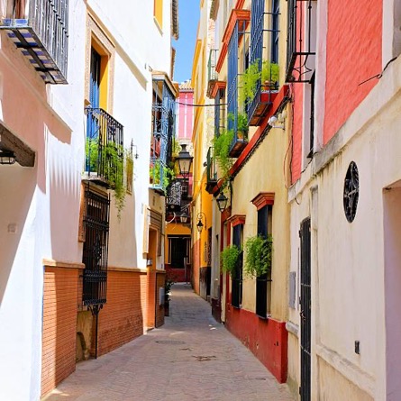
Streets of Seville
Staying in the centre of the city can be crazy. Like many old cities, the thin streets are like crazy spiderwebs with small entrances and exits, twisting turns, restaurants and cafes sprinkled throughout the maze. It took me several days to get used to it. We stayed in two separate locations, one in the centre and one just outside. The maze continues beyond the thin streets, but throws roads and vehicles into the mix with the slow walking locals. Seville has a large shopping areas right next to the maze.

url-2023-04-29-18-55.jpg

Seville Cathedral
The Cathedral of Saint Mary of the See was originally built as a grand mosque in 1172, it was christianised then torn down and rebuilt in 1401 as the grand gothic structure it currently is.

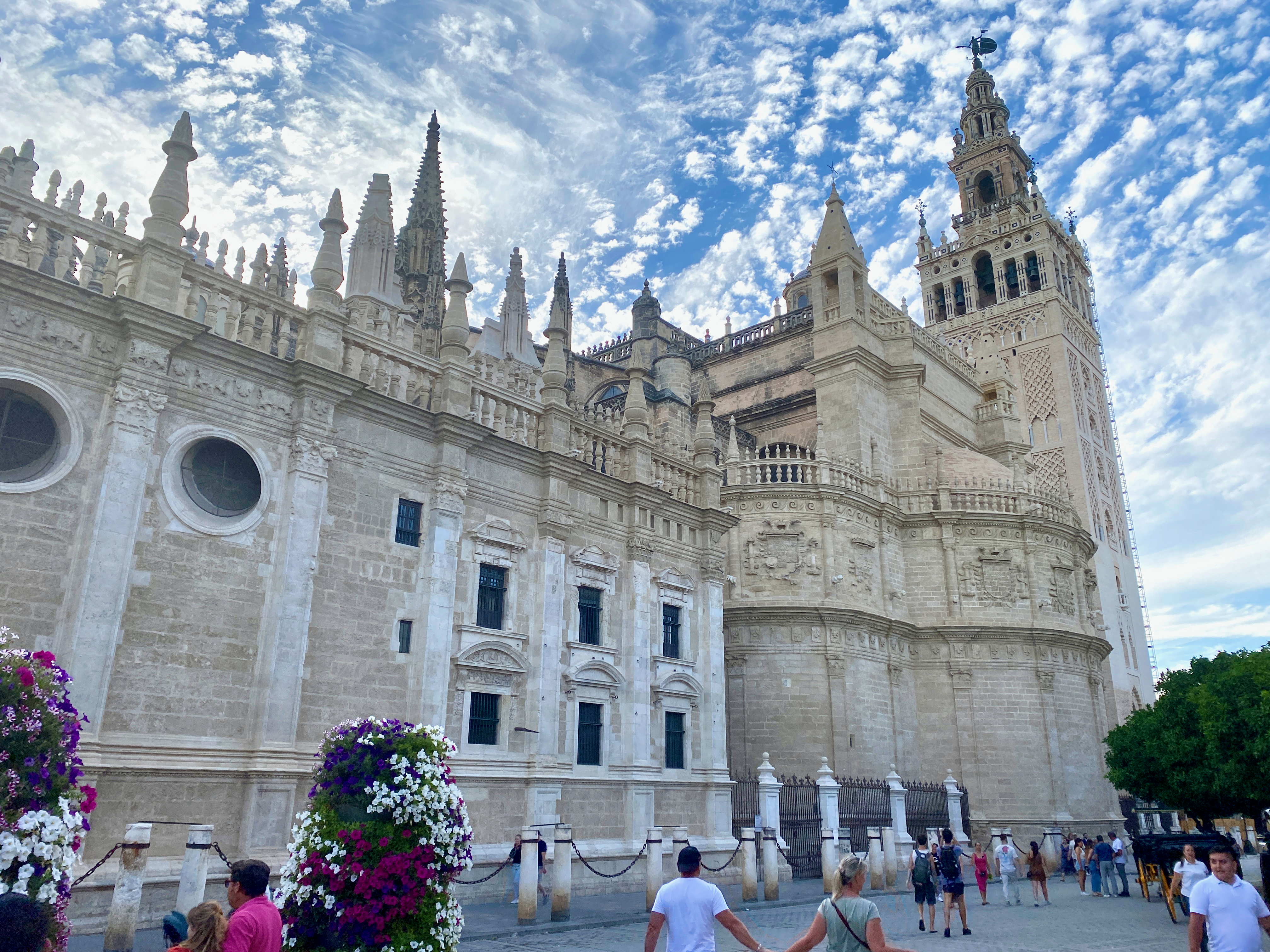
On its completion in the early 16th century, it became the largest Cathedral in the world, replacing the Byzantine church which had held the title for a thousand years. It has since been surpassed by three other structures: St Peter’s Basilica, Cathedral Basilica of our lady Aparecida and Milan Cathedral. Having spent time exploring several other Cathedrals in recent weeks we decided not to explore the interior.


Alcazar de Seville
Situated beside the Seville Cathedral, the Seville Alcazar is a royal palace which was begun in 913 under Muslim rule and took 500 years to complete, during which changes in architectural styles took place.

img_3525-2023-04-29-18-55.png

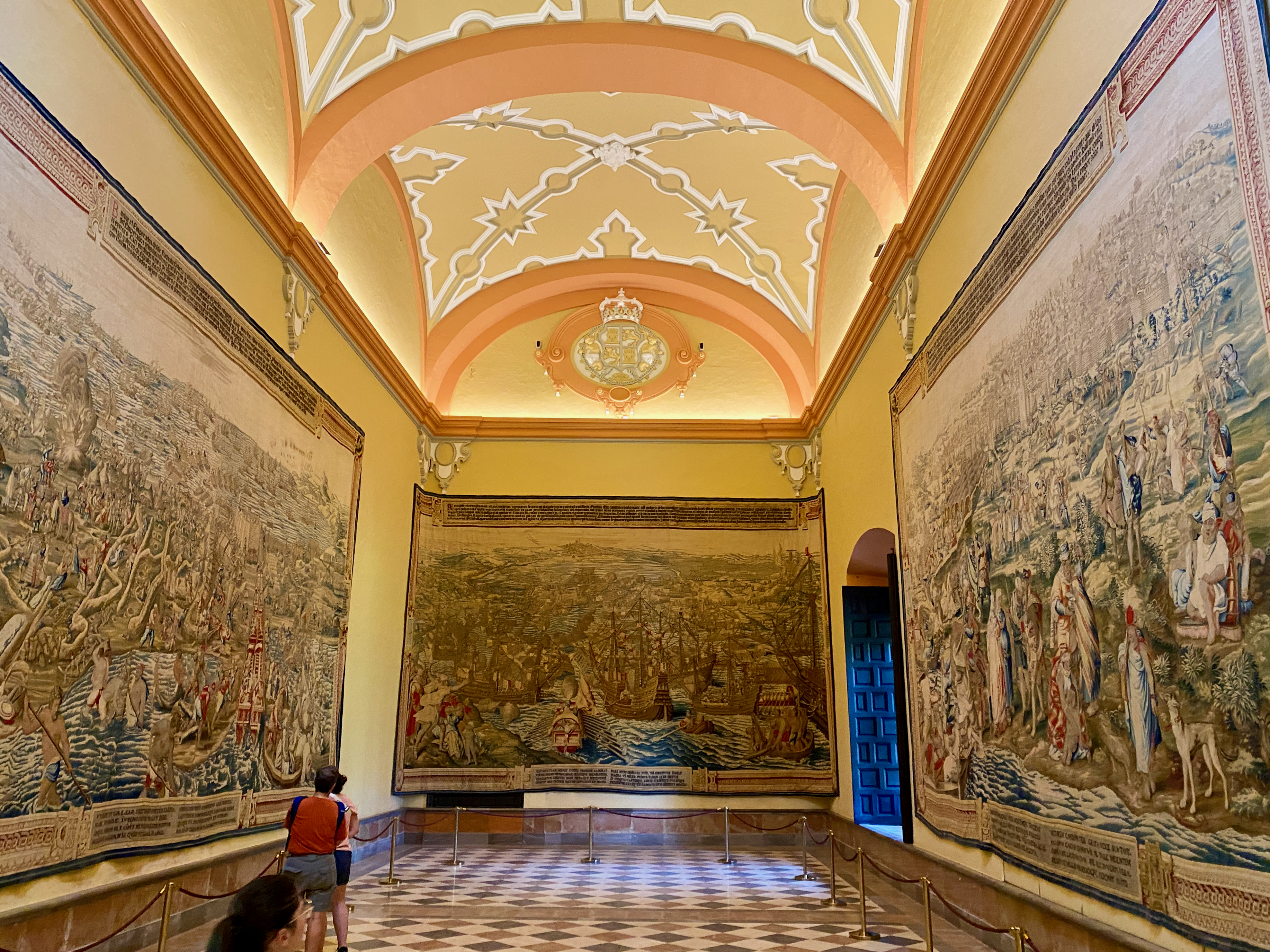
These can be seen throughout with different areas in the palace looking decidedly different. We took a day tour of the building, listening to an audio guide as we went. The gardens surrounding the back of the palace are immense.
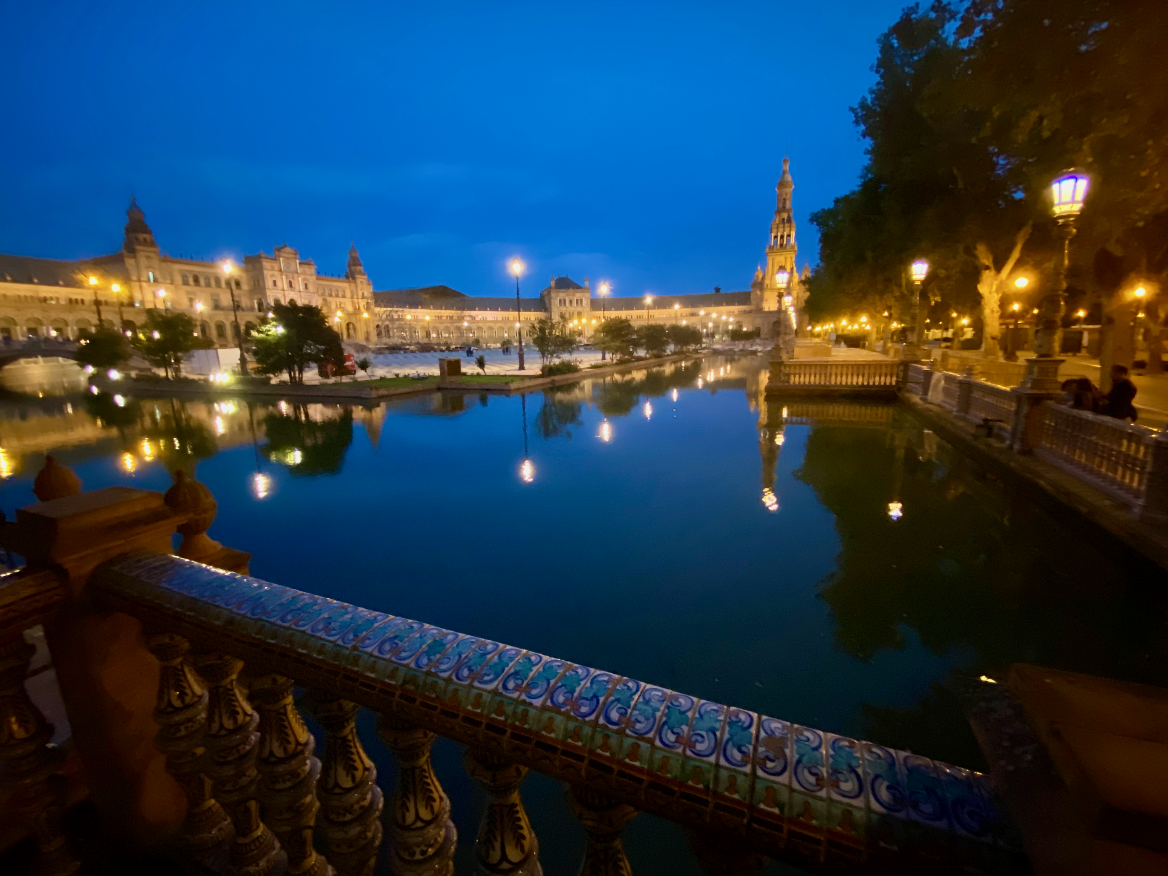
img_3512-2023-04-29-18-55.png

Plaza de Espana

This semi-circular square was built in 1929 and is the most famous square in Seville. It was designed in the renaissance style with a stream running through it crossed by bridges. It’s surrounded by the large Parque de Maria Luisa.

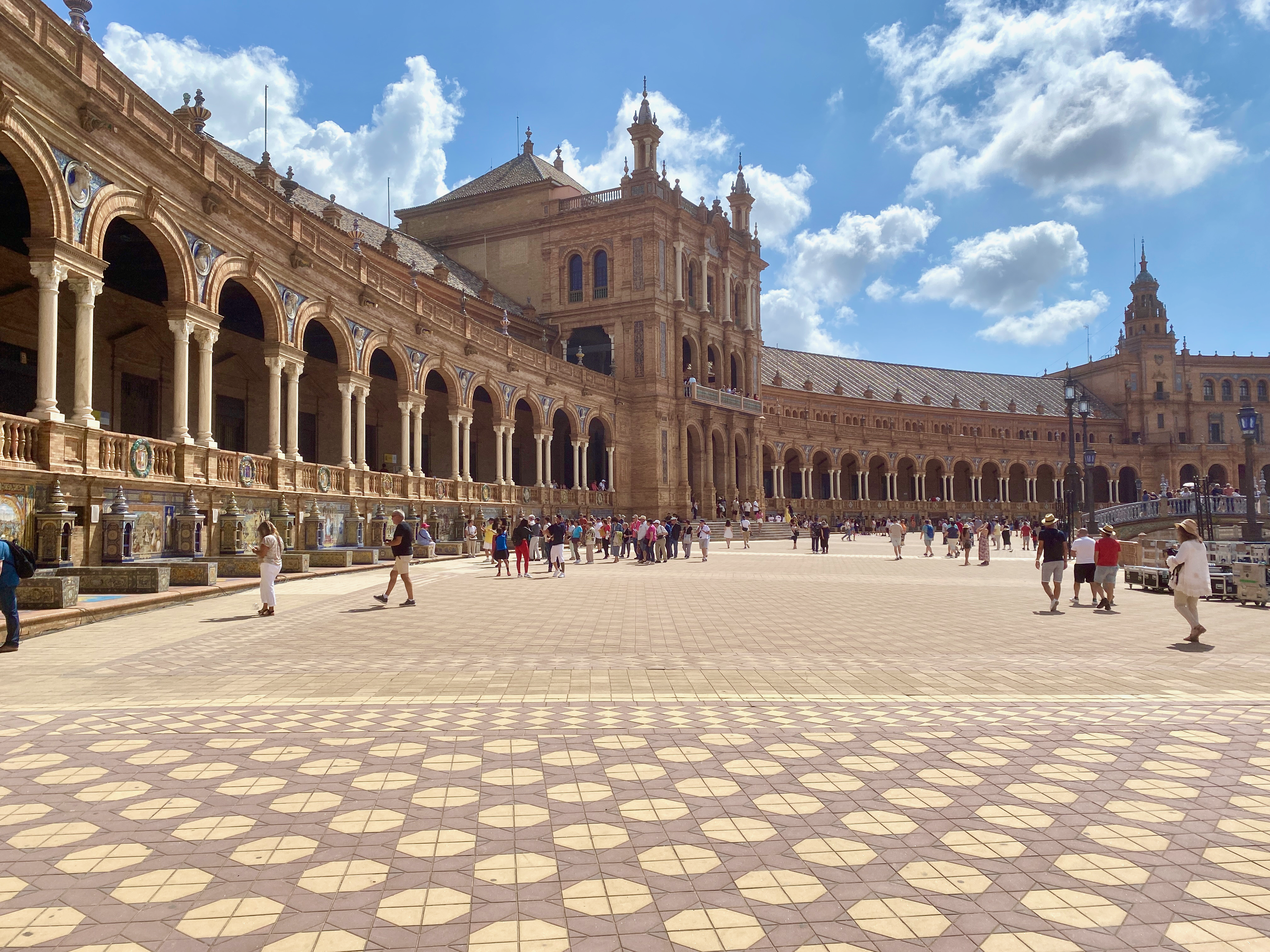
The semicircular building is fringed by tiled seated areas each detailing a province in detail. We spent some time here in both the day and the night. During the day there are performances by dancers and musicians at various places along the plaza. At night, the lights gave it a little more magical feel.

img_3577-2023-04-29-18-55.png

Torre the Oro
This 12th century tower is 36m tall and is known as the Tower of Gold. It was built to control maritime transport along the Guadalquivir river beside which is was built. A heavy chain just under the water helped to stop invading boats coming into the city. Today it hosts a naval museum.

img_3554-2023-04-29-18-55.png

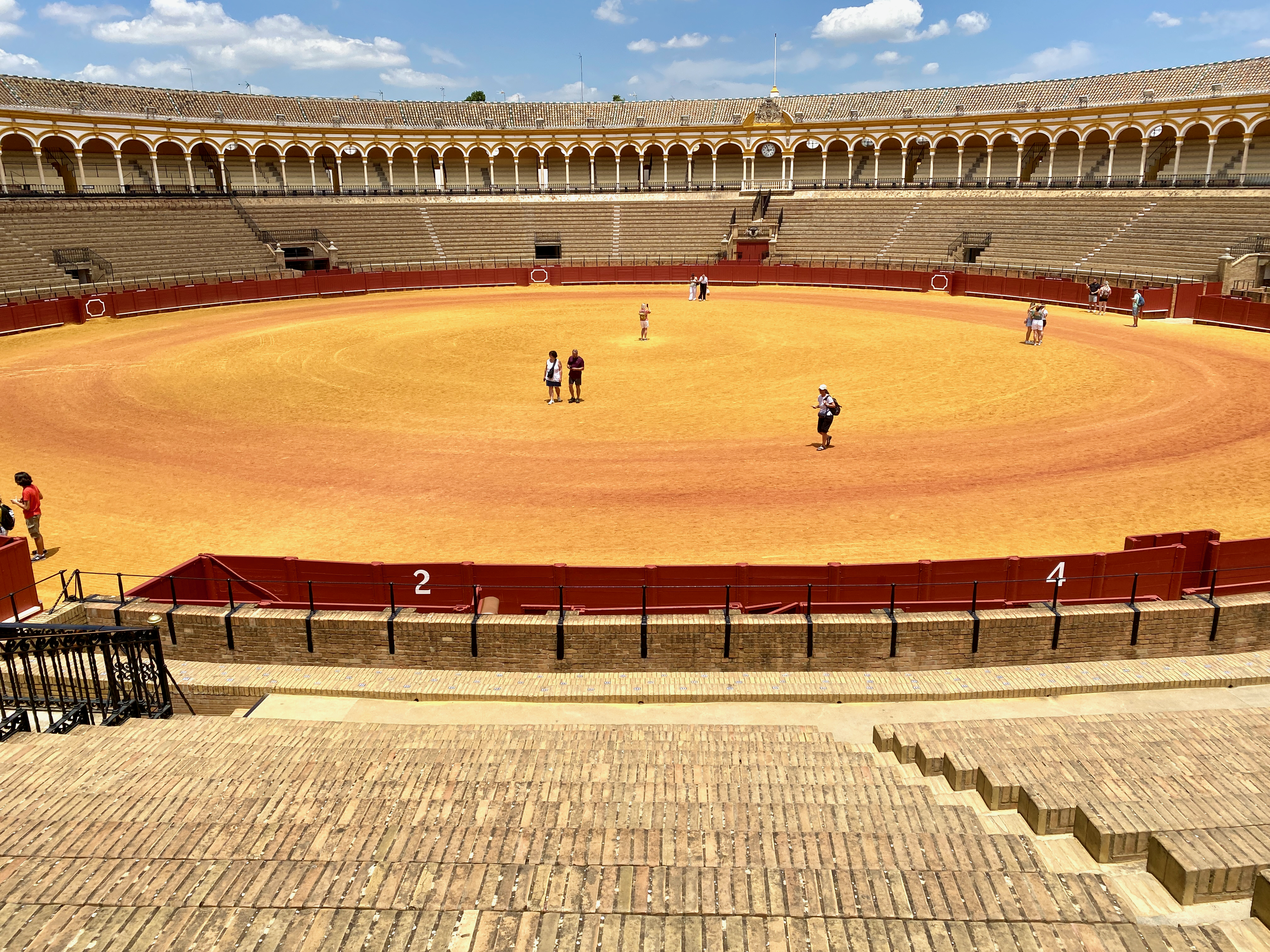
Plaza de toros de la Real Maestranza de Caballería de Sevilla

A visit to Seville is not complete without a tour of one of the most famous bull rings in Spain, which could hold 12,000 people including a box for royalty.

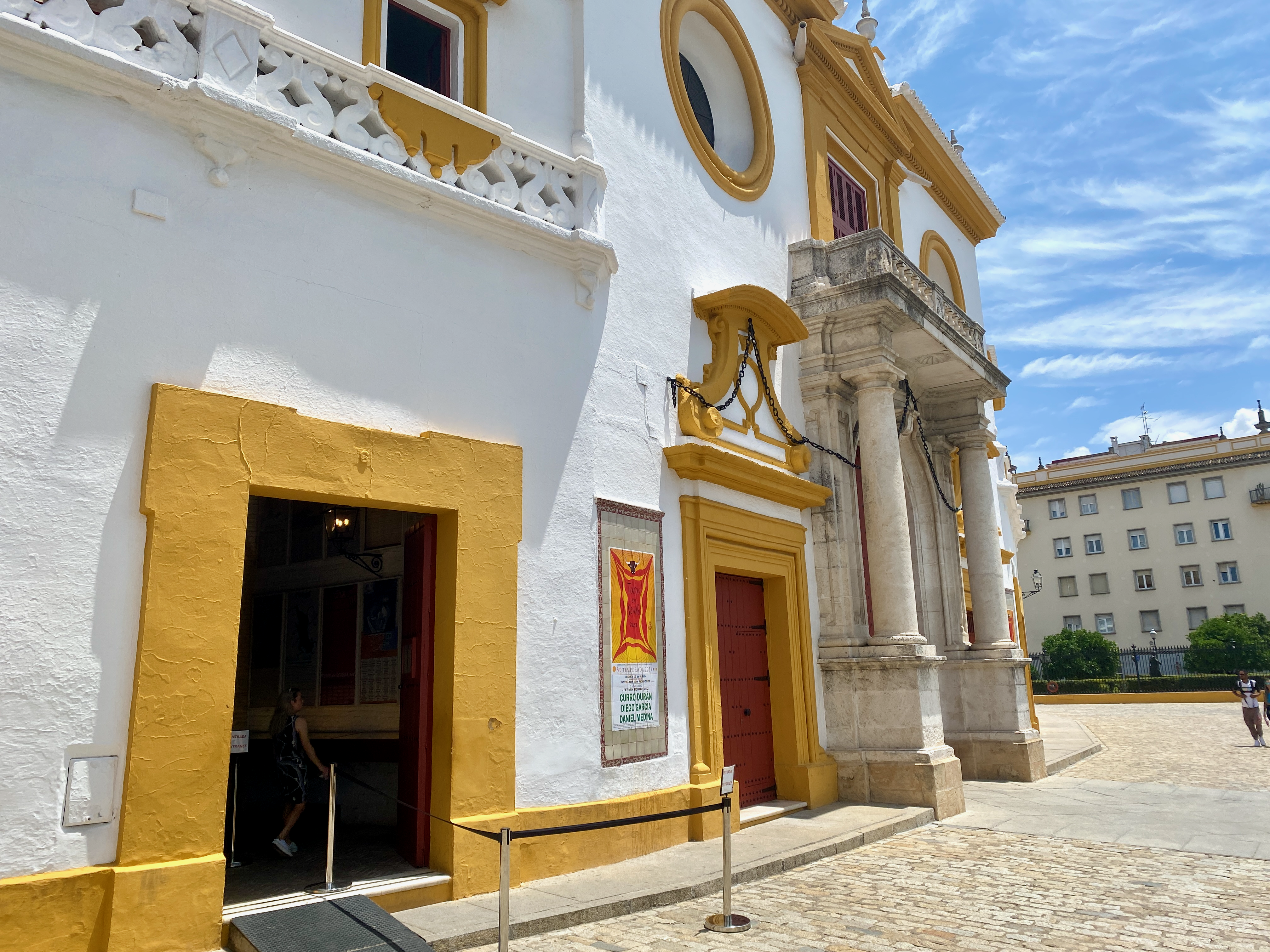
The audio guide going along with the tour detailed the different parts of the ring, and included access to the small museum. Much of the guide went into the feelings of the various members of the crew including the bullfighter himself.

Flamenco
Again, one cannot come to Seville without seeing a Flamenco show. Flamenco is a type of dance developed on this region in the 18th century, and includes twirling and foot stamping along to the sound of flamenco guitar. We attended a Flamenco show, sitting in the front row, and it was exhilarating. The effort of all involved, the skill of the guitarist, dancers and singer were well worth the effort. Unfortunately, photos were not allowed to be taken inside, so this is one kindly provided by the web.

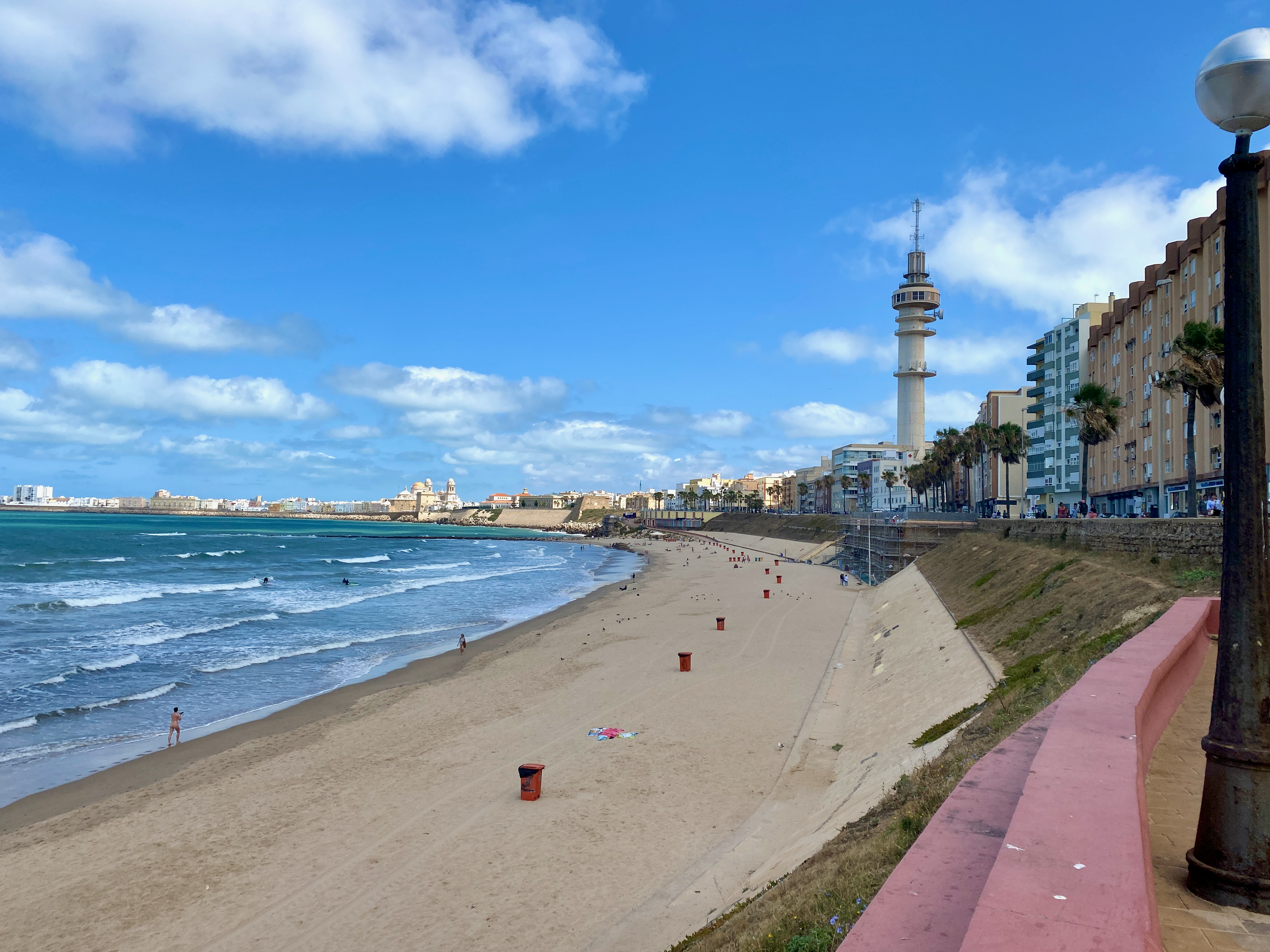
Day trip – The City of Cadiz
Staying in Seville a week, a road trip to the surrounding towns is a must. Renting a car is easy and the best way to get around at your own pace. Cadiz is a port city with great sandy beaches and is known to be one of the oldest continually inhabited cities in Western Europe. In the mid 1800s it took over from Seville as the major port in Southern Spain.
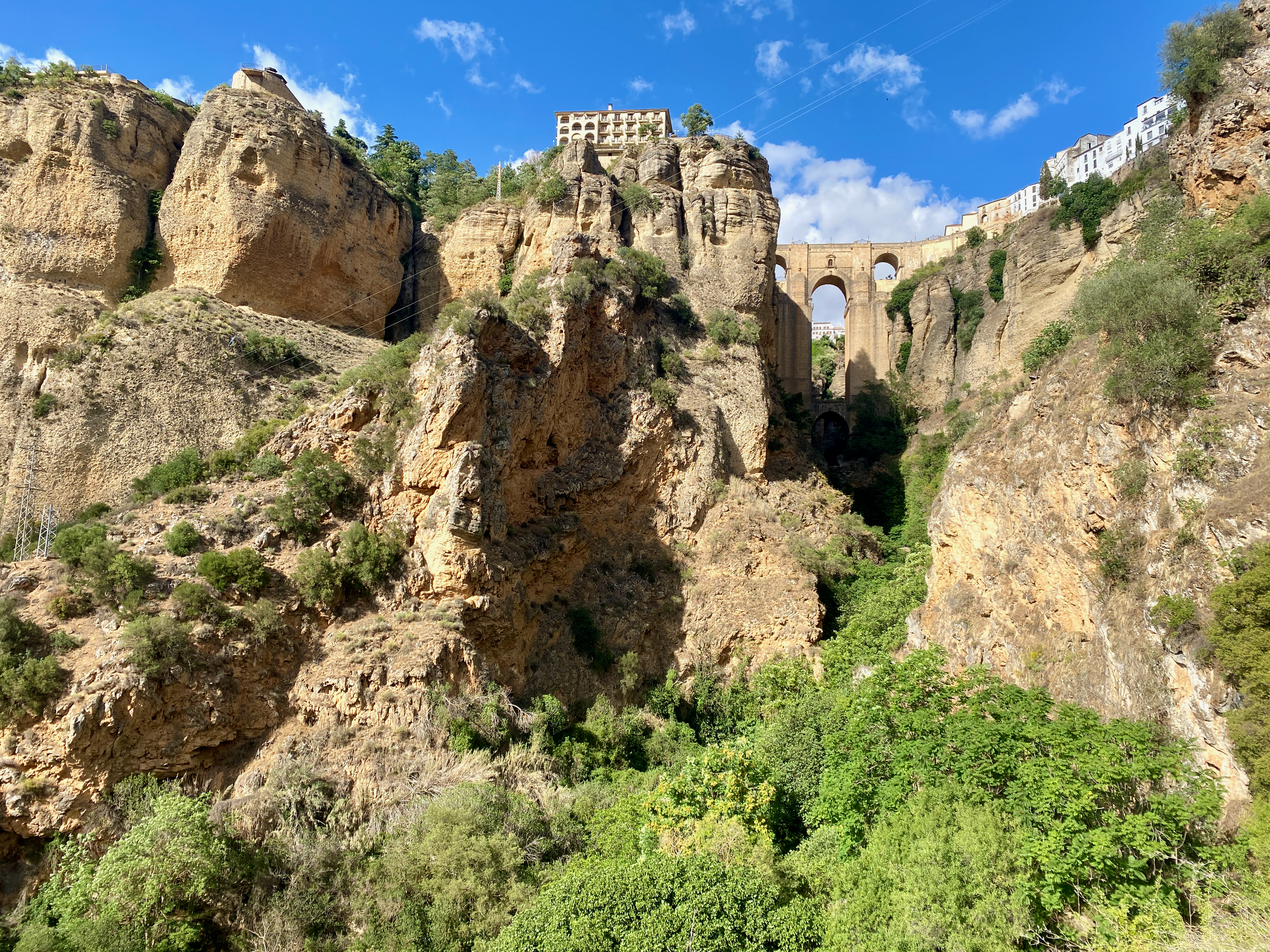
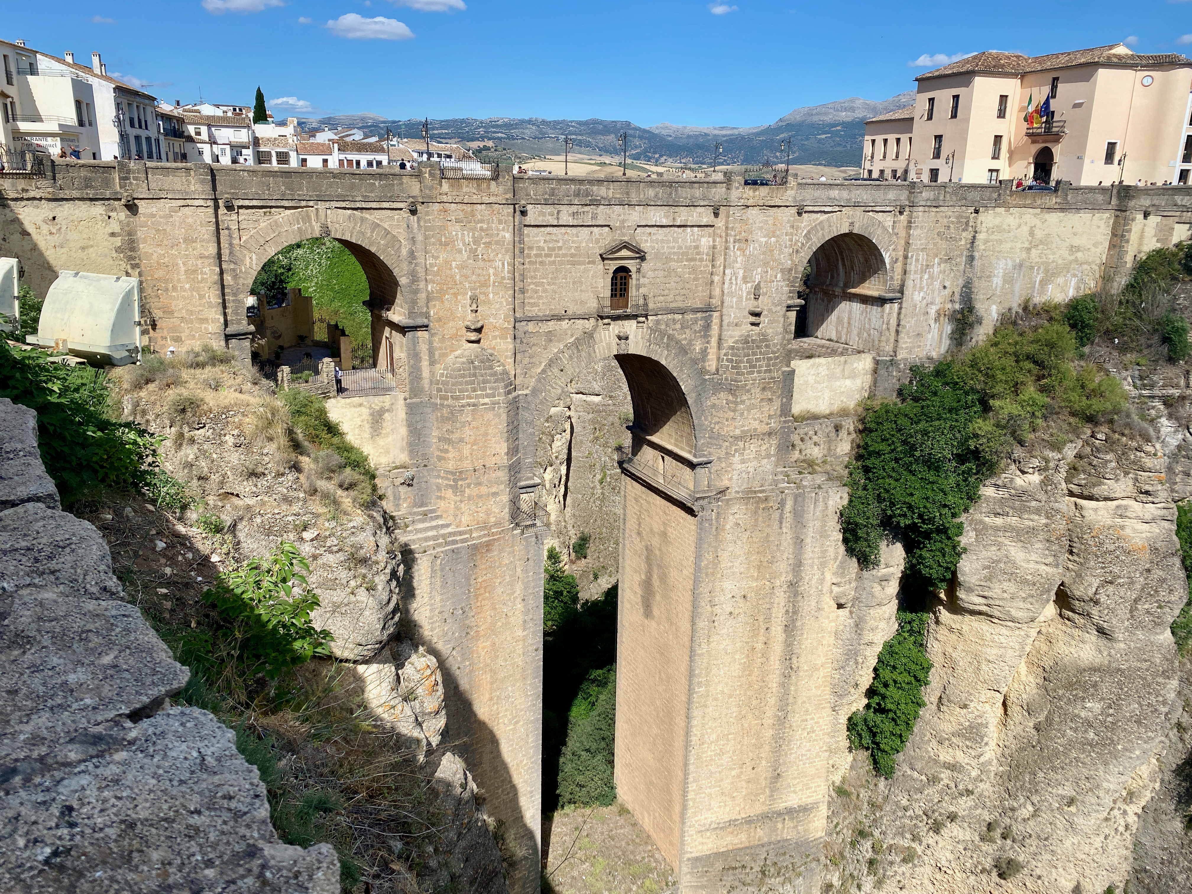
Day trip to Ronda
The small town of Ronda situated atop a mantle of rock is a location that must be seen to believed. It feels like a magical location with grand views across the olive groves.

img_3616-2023-04-29-18-55.png

A new bridge between the two ends of the town was built with great arches crossing the river valley. And after walking from one end of town to the other to find the best view, we drove to the bottom of the valley to look up at it.

Impressions
Seville is well worth a week, and we enjoyed our time both in and out of the city. There’s plenty to see, along with the expansive culture and food. A definite locations for a revisit should I ever return to southern Spain.

img_3626-2023-04-29-18-55.png

Next, I head down to Gibraltar to explore the rock.
The World Wanderer

Hiking Statistics

The following is a list of all Multiday Hikes I’ve completed since I began walking long hikes in August 2011. All but the first has links to the relevant write up I did on each hike.

HikeCountryRegionDaysDistance (km)
1Rainbow Beach Training WalkAustraliaQueensland240
2Larapinta TrailAustraliaNorthern Territory17230
3Conondale Great! WalkAustraliaQueensland356
4Gold Coast Hinterland Great! WalkAustraliaQueensland354
5Yurrebilla TrailAustraliaSouth Australia354
6Major Mitchell Plateau – The GrampiansAustraliaVictoria226
7The Overland TrackAustraliaTasmania765
8Wilsons PromontoryAustraliaVictoria350
9Mt Bogong Big River Circuit – Alpine National ParkAustraliaVictoria350
10Burchell Trail – Brisbane Ranges National ParkAustraliaVictoria338
11Bogong Wilderness – North Koscioscko National ParkAustraliaVictoria242
12Paso de la OvejaArgentinaPatagonia228
13Parque Nacional Torres del PaineChilePatagonia9110
14Mt Fitz Roy TriangleArgentinaPatagonia334
15Cerro Catedral, Parque Nacional Nahuel HuapiArgentinaPatagonia220
16El ChoroBoliviaBolivia349
17Colca CanyonPeruPeru320
18Santa Cruz Trek, Cordillera BlancaPeruPeru350
19El Altar, Sanjay National Park,EcuadorEcuador325
20Ciudad Perdida – Sierra Nevada National ParkColombiaColombia444
21Kalaw to Inle LakeMyanmarMyanmar357
22Land’s End – St Ives to PenzanceEnglandCornwall466
23Boudicca WayEnglandNorfolk358
24Sandstone TrailEnglandCheshire355
25Inn Way of the Lake DistrictEnglandLake District7145
26The Inn Way to the Peak DistrictEnglandPeak District6135
27Great Glen WayScotlandScotland6126
28Arran Coastal WayScotlandScotland6105
29Camino Portugúes de CostaPortugal and SpainPortugal and Spain12280
30Tour du Mont Blanc (TMB)France, Italy and SwitzerlandFrance, Italy and Switzerland10165
31Pinnacles Loop TrackNew ZealandCoromandel217
32Routeburn TrackNew ZealandFiordland332
33Abel Tasman Coastal TrailNew ZealandNelson460
34Travers Sabine Angelus CircuitNew ZealandNelson Lakes680
35Rangitoto Motutapu CircuitNew ZelandAuckland226
36Alpha and Omega, Tararua RangesNew ZealandWairarapa439
37Pouakai Circuit, Mt TaranakiNew ZealandTaranaki323
38Cape Brett TrackNew ZealandNorthland231
39Tongariro Northern CircuitNew ZealandManawatu/Waikato445
40Southern Alps CrossingNew ZealandWest Coast13171
41Aotea TrackNew ZealandGreat Barrier Island342
Total  1862843

Aotea Track, Great Barrier Island, New Zealand

Great Barrier Island is 100km North East of Auckland Central, and sits between the Hauraki Gulf and the Pacific Ocean just to the north of the Coromandel Penninsula. More than half of the island is a nature reserve, and the 1000+ residents live off the grid.

aoteatracklocation-2023-04-5-17-27.png

I first visited Great Barrier 25 years ago, and have been trying to get back to do a hike for months now. I’ ha’d planned it as a warm up hike before my Southern Alps crossing, but it wasn’t to be. First, a downpour flooded Auckland, including the airport, so I couldn’t fly out, then the Island was closed down due to the Cyclone Gabrielle. Now, a month after completing my Southern Alps crossing, and I finally made it.

Day 1: Whangaparapara Road to Mt Heale Hut – 8.2 km – 3.5 hours – Red Track

I’d tossed around catching the car ferry over, but with the extra costs associated with it, flying was only a little more expensive. So, after a quick 30 minute flight in a 12 seater Cessna aircraft, I arrived on the island.

img_1445-2023-04-5-17-27.png

I’d arranged to be collected from the airport and delivered to the trailhead by a local transport. I arrived at 2:10 pm, and with an estimated 4 hours walk, I set out along a wide track beside a stream. As daylight savings ended last night, sunset was going to be just after 6, so I was going to be close.

img_1308-2023-04-5-17-27.png

Along the trail I got my first look across the grasslands, with views of the short mountains beyond.

img_1312-2023-04-5-17-27.png

The trail was flat and the smell of sulphur in the air heralded in my arrival at the ‘hot springs’. The springs themselves were more of a luck warm stream with pools along it. I might have gone in if I hadn’t been pressed for time, although as they weren’t quite hot, they lost their appeal.

img_1318-2023-04-5-17-27.png

Not long after the hot springs, I arrived at the Tramline trail where Kauri Trees were logged more than 100 years ago. A view out over the grasslands to Kaitoke and Medlands Beaches.

img_1319-2023-04-5-17-27.png

The Tramline track was also flat until it headed up Peach Tree Trail, which began a crazy amount of steps. This would be a reccuring theme on the island.

img_1334-2023-04-5-17-27.png

Starting near sea level, I climbed towards the the hut at 412m. The lack of breeze ensured that my climb felt more like I was swimming up the mountains in my own sweat. But the views were worth the energy.

img_1341-2023-04-5-17-27.png

And I got a better look back to Kaitoke and Medlands Beaches as I got higher. The trees gave way to low scrub giving an almost alpine feel on a mix of dirt path and stairs.

img_1352-2023-04-5-17-27.png

At the 400m altitude mark, I saw the sign to the Hut stating 5 min and 200 m. I arrived soon after and found a family group of 4 already there. I went in, claimed a bunk, had a quick hiker’s shower before going out to watch the sunset. Then while chatting to the family members, I cooked a Chef Corso Trail Meal, Macaroni with Bacon and Blue Cheese.

img_1357-2023-04-5-17-27.png

Day 2: Mt Heale Hut to Kaiaraara Hut via Mt Hobson Lookout and Port Fitzroy – 16.9km – 4.75 hours – Pink Track

After a fitful night’s sleep, I arose and got ready for today’s walk. First, I climbed past Mt Heale to the summit of Mt Hobson, the tallest mountain on the island, at 627m. I was to have climbed past Mt Hobson and along the ridgeline to the next hut, but due to a slip the trail that was was closed. So I’d left my pack at the hut.

img_1363-2023-04-5-17-27.png

I knew there was going to be a lot of steps, as others in the hut had complained about the sheer number. I didn’t bother counting on the way up, concentrating on the climbing until I reached the summit platform with almost 360 degree views. This over Whangapoua Bay…

img_1373-2023-04-5-17-27.png

and this over Port Fitzroy with Kaikoura Island, in the centre, and Little Barrier Island, in the distance.

img_1374-2023-04-5-17-27.png

I counted 1016 stairs on the way back to the hut where I picked up my pack and headed straight off again. A sign at the top of the South Fork Track said an hour to the Forest Road, not far from the hut. So it was going to be a short day. The trail headed down slowly, crossing a wire bridge as it went.

img_1379-2023-04-5-17-27.png

The trail was wide and an easy descent. Along the way I passed a pair of woman, the only two people I’d see on the track today.

img_1386-2023-04-5-17-27.png

The trail crossed a stream several times, and was easy to avoid getting my boots wet, although the trail was a little muddy and slippery at times. I finally came out at the Forest Road after an hour and a half. Not sure where they got an hour from as I wasn’t walking slowly. The Forest Road is rocky road though the nature reserve, and the sign said 30 minutes to the hut, but it only took 10 minutes.

img_1390-2023-04-5-17-27.png

At the hut I ran into one of the ladies from the hut last night. It was early, so we decided to walk the 5km into Port Fitzroy. I’d heard there was a burger place, which turned out to be closed, so we continued walking to the Boat Club, hoping for a burger, but that was also closed. We did manage to persuade the owner to sell us a beer though. Afterwards, we stopped at the shop on the way back. That evening we discovered there were mice under the hut, as my hutmate had left a bag outside with a chocolate bar in it. The mice enjoyed that. Thankfully they couldn’t get inside.

Day 3: Kaiaraara Hut to Green Campsite via Mt Maungapiko – 17km – 4 hours – Green Track

Today would be the longest day, although most of it would be spent walking along the Forest Road. Unfortunately, there wasn’t much of a view most of the time, so I took whatever photos I could.

img_1406-2023-04-5-17-27.png

Then a short side trail with a bunch of stairs led down 50m to a pair of large Kauri Trees. After the logging a century ago, there were few of the ancient giants left, and with Kauri Dieback Disease, there are likely to be few others living to such greatness.

img_1418-2023-04-5-17-27.png

30 minutes later, I came to the turn off to Mt Maungapiko, a 280m peak with good views. It was the only climb off the Forest Road, and in time for lunch, so I took the opportunity, and climbed the rough rock to the top where there’s a wooden bench.

img_1426-2023-04-5-17-27.png

I stopped for lunch, taking photos of the near 360 degree views.

img_1421-2023-04-5-17-27.png

And back the way I’d come.

img_1425-2023-04-5-17-27.png

Back on the Forest Road, I headed down to a stream, the climbed for the final time before finally reaching the South Tramline Track. The actual metal tramline had been removed many years ago, leaving just a steep descent. About halfway down I came to the turnoff to the Kauri Falls, and stopped to have a look.

img_1432-2023-04-5-17-27.png

Then it was a fairly easy walk, crossing numerous streams via wooden bridges, before I came out near Whangaparapara, then a 7 minute walk to the Green Campsite, opposite the village. I set up my tent, then went for a short walk along the main road of Whangaparapara hoping to find a beer at the lodge, but it was closed. So, I just chilled, reading in the sun.

img_1437-2023-04-5-17-27.png

The next morning, I packed and had breakfast, before I met the trail transport guy who dropped me off at the airport for my 30 minute flight home.

Overall

The hike was a fairly easy walk over three days, and would have made the perfect warmup hike had it not been for the weather events. I enjoyed my time there in relative quiet.

The Lone Trail Wanderer